 |
|
|
|
|
|
|
|
|
|
|
|
|
|
|
|
|
|
|
|
|
|
|
|
|
|
|
|
|
|
|
|
|
|
|
|
|
|
|
|
|
|
|
|
|
|
|
|
|
|
|
|
|
|
|
|
|
|
|
|
|
|
|
|
|
|
|
|
|
|
|
|
|
|
|
|
|
|
|
|
|
|
|
|
|
|
|
|
|
|
|
 |
|
|
|
|
 |
|
 |
|
|
|
|
|
|
|
|
|
|
|
|
|
|
|
|
 |
|
|
|
|
|
|
|
|
|
|
|
|
|
|
|
 |
|
|
|
|
|
|
|
|
|
|
|
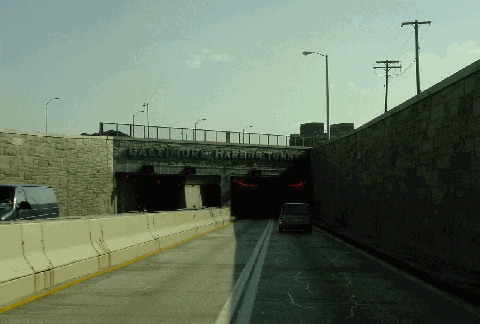
This 2002 photo shows the southbound Harbor Tunnel Thruway (I-895) approaching the Harbor Tunnel. Soon after the nearby Fort McHenry Tunnel (I-95) opened in 1985, work began on a multi-year reconstruction of the tunnel and approach roads. (Photo by Jim K. Georges.)
|
|
|
|
|
|
|
|
|
 |
|
|
|
|
 |
|
|
|
|
|
|
|
|
Construction started:
Opened to traffic:
Number of tubes:
Number of traffic lanes:
Length between portals:
Operating headroom of tunnel:
Roadway width:
External diameter of tunnel:
Maximum depth, mean high water to roadway:
Length of each immersed tunnel section:
Number of immersed tunnel sections:
Total number of tiles:
Supply and exhaust fans:
Cost of original structure:
|
|
|
|
|
|
|
|
|
April 23, 1955
November 30, 1957
2 tubes
4 lanes
7,650 feet (2,331.7 meters)
14 feet (4.3 meters)
24 feet (7.3 meters)
40 feet (12.2 meters)
101 feet (30.8 meters)
310 feet (94.5 meters)
21 sections
6,500,000 tiles
32 fans
$130,000,000
|
|
|
|
|
|
|
|
|
|
|
|
|
|
 |
|
|
|
|
|
|
|
|
|
14.9 miles (23.9 kilometers)
1955-1973
|
|
|
|
|
|
|
|
|
 |
|
|
|
|
|
|
|
|
Passenger car cash toll
Passenger car EZ-Pass toll:
|
|
|
|
|
|
|
|
|
$4.00
$3.00 (MD EZ-Pass only); $4.00 (non-MD)
|
|
|
|
|
|
|
|
|
|
|
|
 |
|
 |
|
|
|
|
|
Hazmat and height restrictions apply.
|
|
|
|
|
|
|
|
|
|
|
|
|
|
|
|
|
|
|
|
|
"Nothing is too good for Baltimore. I am building you a tunnel to last one thousand years." - Ole Singstad, designer of the Baltimore Harbor Tunnel
|
|
|
|
|
|
|
|
|
|
|
|
EARLY PLANS FOR A BRIDGE: In 1931, Governor Albert Ritchie appointed a commission to study the need for bridges in the state of Maryland. The commission's report recommended the construction of a major bridge across Baltimore Harbor (Patapsco River), along with other bridges over Chesapeake Bay, the Potomac River, and the Susquehanna River. Because of the steep costs of the four proposed crossings - their construction would have raised the state's total debt load by 70% - the commission recommended that revenue bonds be issued. The bonds, which were to pay interest of 1.75% to 2.25%, were to be financed by tolls.
|
|
|
|
|
|
|
 |
|
|
|
|
|
|
|
|
|
|
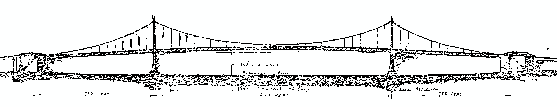
One of the initial plans called for a four-lane suspension bridge with a north-south orientation from Broadway (at Bank Street) in the Fells Point community to Fort Avenue (at Hull Street) near Fort McHenry. It was to have a 1,500-foot-long main span flanked by 750-foot-long side spans, and a 140-foot clearance at mid-span. The US War Department approved this plan in 1938, ruling that the proposed bridge did not interfere with navigation, but the permit expired in 1941. Preparations for war - specifically, the need to keep Baltimore Harbor navigable - likely delayed construction, but the lack of any connections for a future highway network did not help matters.
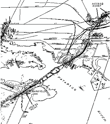
In 1943, the Maryland State Roads Commission (SRC) submitted revised plans for a combined 14.3-mile bridge and highway network bypassing downtown Baltimore. The proposed route, which was to "embody the features of freeway design," was to extend northeast from Washington Boulevard (US 1) near Elkridge (Halethorpe) to the junction of Pulaski Highway (US 40) and Erdman Avenue in the Orangeville community of Baltimore, along the same corridor as the modern Harbor Tunnel Thruway. The combined bridge and highway was to have the following design attributes:
|
|
|
|
|
|
|
|
|
|
|
|
|
|
|
|
|
BRIDGE: The bridge was to be of a seven-span, cantilever-truss design with a 1,296-foot-long main span and a 150-foot vertical clearance. The 52-foot-wide roadway was to accommodate four vehicular lanes and a center steel median barrier. There was to be a 2% roadway grade. The maximum height was the bridge was to be 250 feet, down from 337 feet in the original suspension design. The bridge originally was estimated to carry 11,000 vehicles per day (AADT).
|
|
|
|
|
|
|
|
|
|
|
|
|
|
|
|
|
|
CONNECTING HIGHWAY: The highway was to consist of a 50-foot-wide roadway accommodating four vehicular lanes a center steel median barrier. Curves were to be "long and "sweeping" (though no specific criteria were established), and the maximum grade was set at 2%. Interchanges were to be grade-separated and "of the latest design." Adequate guiderails and fencing were to be provided along the length of the highway.
Since the "Harbor Bridge" was to be self-financing, the SRC gave priority to its construction ahead of a proposed east-west highway through the heart of downtown Baltimore; this "East-West Expressway" ultimately was canceled decades later. The Maryland Legislature approved construction of the Harbor Bridge in 1947 and the US Congress (whose approval was required for construction across navigable waters) followed suit the following year. However, with most of the SRC's attention on building the Chesapeake Bay Bridge (US 50 and US 301), construction of the Baltimore Harbor Crossing had to wait.
|
|
|
|
|
|
|
|
|
|
|
|
|
|
|
|
 |
|
|
|
|
 |
|
|
|
|
|
TOP: This engineer's sketch shows the SRC's 1938 plan for a suspension bridge across Baltimore Harbor from Fells Point to Fort McHenry (Fairfield). LEFT: This drawing shows the SRC's 1943 plan for the proposed bridge and highway bypass of Baltimore. It was the genesis of the modern Harbor Tunnel Thruway (I-895). (Drawings from the Maryland State Archives, Enoch Pratt Free Library-Baltimore.)
|
|
|
|
|
|
|
|
|
|
|
|
|
|
|
|
|
|
|
|
|
|
TUNNELING UNDER BALTIMORE HARBOR: In 1953, the SRC initiated a second study of the highway across the Patapsco River, including preliminary traffic and engineering investigations. As a result of this study, the SRC developed plans for a four-lane tunnel under the Patapsco River and a network of connecting highways. The Army Corps of Engineers, which weighed in favor of a tunnel (instead of a bridge) because of navigation and defense concerns, approved the revised design on August 3, 1954.
|
|
|
|
|
|
|
|
|
|
|
|
|
|
The SRC hired Singstad and Baillie, a New York engineering firm with extensive experience in designing vehicular tunnels. It also obtained the services of the J.E. Greiner Company, a Baltimore engineering firm, to assist with the design of the tunnel and connecting highway sections.
The 7,650-foot-long Harbor Tunnel is comprised of a mix of immersed-tube and cut-and-cover sections that connect to the portals. It was to be the fourth longest underwater vehicular tunnel in the world (behind New York's Brooklyn-Battery, Holland, and Lincoln tunnels, all designed by Ole Singstad).
IMMERSED-TUBE SECTION: Not far from the tunnel site, workers at the Maryland Shipbuilding and Drydock Company fabricated 21 tunnel sections averaging 310 feet in length. The immersed-tube tunnel sections, which actually are twinned (one tube for each roadway) and form the heart of the tunnel, were towed from the fabrication site to the tunnel site and submerged one by one. Workers sunk the first tube section into Baltimore Harbor on April 11, 1956. Once the immersed-tube sections were placed, a mix of rock and backfill was placed to secure them. The bulkheads at the end of each section were removed when the sections were joined.
CUT-AND-COVER TUNNEL SECTIONS: Two cut-and-cover tunnel sections extended from the ends of the immerse tube tunnel section to the north and south portals. These sections were made of structural steel encased by reinforced concrete.
Two ventilation buildings - one on each of each portal - have a combined 32 exhaust fans that distribute air in and out of the tunnel. In the tubes themselves, fresh air is distributed through a duct under the roadway and distributed through flues placed at intervals along the roadway. Exhaust air into drawn off above the roadway through exhaust air ducts placed at intervals in the ceiling.
The tubes range from a minimum of 50 feet from low water to cover (as prescribed by the Army Corps of Engineers) to a maximum of 101 feet. Each tube accommodates a 22-foot roadway for two vehicular lanes; there are also flanking sideways measuring two feet, eight inches wide. There is a 14-foot vertical clearance; however, vehicles with a height of 13 feet, six inches are prohibited from the tunnel. The maximum grade in the tunnel and open ramps is 3.5%; the maximum speed limit in the tunnel was set at 35 MPH.
THE "THRUWAY" SECTIONS: The SRC planning documents established design speeds at 60 MPH in the "urban" section of highway north of the tunnel and 70 MPH in the "rural" section south of the tunnel; the maximum speed limit throughout the route was 55 MPH. Maximum grades were set at three percent on the main roadways and four percent on the ramps. Retaining walls were built along a four-block depressed section of highway north of the Canton (north) portal. South of the Fairfield (south) portal, a 790-foot-long, ten-span steel through-truss bridge was built to carry the highway over a Baltimore and Ohio rail yard.
As in the 1943 plan, the original highway extended from US 1 near Elkridge to US 40 near the northeast edge of Baltimore City. However, a two-mile-long spur route was added to connect the Harbor Tunnel Thruway to the Glen Burnie Bypass (then MD 3, now part of I-97) and Ritchie Highway (MD 2).
OPEN IN TIME FOR THE ARMY-NAVY GAME: The Harbor Tunnel Thruway and 15 miles of connecting roadways were opened to traffic on November 30, 1957, nearly two months ahead of schedule. There was a 40-cent toll for passenger cars when the tunnel-highway complex opened. In its first day of use, thousands of motorists streamed northward to Philadelphia for the annual Army-Navy football game.
With the opening of the tunnel, travel time through Baltimore was cut from about one hour to 12 minutes as motorists no longer had to navigate than more than 50 traffic lights along US 1 and US 40. It also reduced traffic tie-ups on major Baltimore streets by at least 30 percent. In its first year of use, the Harbor Tunnel Thruway had an average daily volume of 21,000 vehicles per day, far below the 60,000-vehicle capacity.
|
|
|
|
|
|
|
|
|
|
|
|
|
|
|
 |
|
|
|
|
|
|
|
|
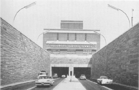
This 1957 photo shows the Harbor Tunnel Thruway (I-895) shortly after it opened. (Photo from the Maryland State Archives, Enoch Pratt Free Library-Baltimore.)
|
|
|
|
|
|
|
|
|
|
|
|
|
|
|
|
|
|
|
|
|
|
|
|
|
|
|
|
|
|
THE "DE FACTO" I-95: The SRC extended the Harbor Tunnel Thruway north from US 40 to the newly completed Northeast Expressway / John F. Kennedy Memorial Highway (I-95) at the Baltimore city line in 1963. The Maryland Transportation Authority (MdTA), a state-run toll authority that took over jurisdiction of the tunnel-and-highway facility, extended the Harbor Tunnel Thruway to I-95 in Elkridge in 1973; the connecting section of I-95 had opened two years earlier.
|
|
|
|
|
|
|
|
|
|
|
|
|
|
As sections of I-95 opened to the north and south of Baltimore, average daily volumes skyrocketed far beyond the tunnel's 60,000 vehicle-per-day capacity. City and state officials at an impasse over the construction of I-95 through Baltimore City, and the Harbor Tunnel Thruway, which at the time did not have an Interstate designation and thus did not receive Interstate matching funds, had become overburdened as it had become the "de facto" I-95.
FINALLY, SOME RELIEF: The opening of the Francis Scott Key Bridge (I-695) in 1977 provided modest relief for travelers through Baltimore, but the route was more circuitous than the direct route provided by the Harbor Tunnel. Moreover, the Baltimore Beltway / Key Bridge route provided only one lane in each direction on the approaches to the bridge.
As the path of I-95 through Baltimore was established and work got underway on closing the gap, Maryland officials proposed a new designation for the Harbor Tunnel Thruway: I-895. The first I-895 signs appeared during the early 1980's, clearly marking the Harbor Tunnel Thruway as an alternate route for the I-95 / Fort McHenry Tunnel route when it opened.
More permanent relief came on November 23, 1985, with the opening of the eight-lane Fort McHenry Tunnel. The completion of the Fort McHenry Tunnel, whose route roughly parallels that of the older Harbor Tunnel, brought an end to the nearly 30-year stalemate over routing I-95 through Baltimore City.
REBUILDING THE HARBOR TUNNEL: In March 1987, the MdTA began an ambitious two-year, $35 million project to renovate the tunnel and its 18 miles of viaducts and approach highways. Workers shut down the northbound tube and roadway during the first year of construction, shifting to the southbound tube and roadway during the second year. Although through traffic was reduced to one lane in each direction through the duration of the project, the burden on area motorists was not onerous because most of the I-95 through traffic already had shifted to the newer Fort McHenry Tunnel.
A TERROR SCARE: On October 20, 2005, the Harbor Tunnel Thruway was shut down completely and the nearby Fort McHenry Tunnel was reduced to one lane in each direction for two hours because of an unspecified bomb threat.
REBUILDING THE I-95 / I-895 NORTHERN TERMINUS: As part of the Maryland Transportation Authority's (MdTA) project to rebuild I-95 northeast of Baltimore, the state rebuilt the northern terminus of the Harbor Tunnel Thruway to eliminate the left-lane exit and entrance ramps between I-95 and I-895. The $830 million I-95 project, which began in 2006 and was completed in 2011, included direct ramps to connect I-895 with the I-95 express toll lanes, as well as direct ramps to and from Moravia Road.
REBUILDING THE CANTON VIADUCT: In 2016, work began on a $290 million project to rebuild the Canton Viaduct, a 3,155-foot-long elevated roadway carrying I-895 over the Canton (CSX / Norfolk Southern) rail yard and local streets serving the Seagirt Marine Terminal just north of the northern end of the Harbor Tunnel. The viaduct also crosses under I-95.
The work consists of demolishing and rebuilding the viaduct, replacing the northbound off-ramp at EXIT 10 (Holabird Avenue), and repairing roadway approaches and retaining walls at the northern tunnel portal. The demolition work comprises the removal of 65 bridge piers, while 37 new piers will be built. Parts of the viaduct will be brought onto solid ground through backfilling, reducing the need for as many piers. The work is being staged over a four-year period, with one lane targeted for full-time closure per year, and peak direction flows are being staggered such that two lanes southbound and one lane northbound will be available during the morning rush, while two lanes northbound and one lane southbound will be available during the afternoon rush. The project is scheduled for completion by 2020.
THE TUNNEL TODAY: According to the MdTA, the Harbor Tunnel Thruway carries approximately 70,000 vehicles per day (AADT). The Harbor Tunnel Thruway serves as an effective bypass of downtown Baltimore, particularly during weekday rush hours and weekend sporting events. Together with I-97, I-895 provides a critical link from the Annapolis area to points north of Baltimore. The speed limit on I-895 is 50 MPH through Baltimore City and 55 MPH outside city limits. Traffic volumes on I-895 dipped in the years immediately after the opening of the Fort McHenry Tunnel, but volumes since have returned to near capacity. In 2010, the MdTA removed the four innermost tollbooths and replaced them with two 30 MPH "high- speed" lanes (one northbound and one southbound).
|
|
|
|
|
|
|
|
|
|
|
|
|
|
 |
|
 |
|
|
|
|
|
|
|
|
|
|
|
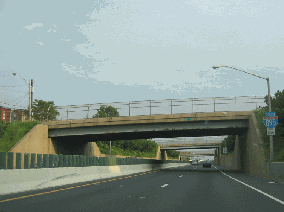
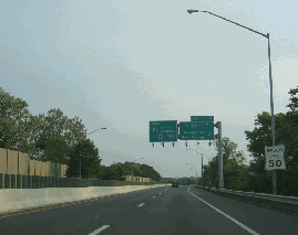
These 2006 photos shows the southbound Harbor Tunnel Thruway (I-895) at the Fleet Street overpass in Baltimore City north of the tunnel (left photo) and at EXIT 6 (I-97) in Baltimore City south of the tunnel (right photo). (Photos by Laura Siggia Anderson.)
|
|
|
|
|
|
|
|
|
|
|
|
|
|
 |
|
 |
|
|
|
|
|
MULTIPLEX WITH I-97: The I-97 designation should be extended north through the Harbor Tunnel to the I-95 / I-895 junction at the Baltimore City line. In conjunction with a proposed I-97 extension south along US 301 to Virginia, the I-97 designation would provide motorists a through traffic route to bypass I-95 congestion in Baltimore and Washington.
|
|
|
|
|
|
|
|
|
|
|
 |
|
|
|
|
|
|
|
|
|
|
|
|
|
|
|
|
|
|
|
|
|
 |
|
|
|
 |
|
|
|
|
|
SOURCES: "Proposed Baltimore Harbor Bridge and Its Arterial Highway Connections," Maryland State Roads Commission (1943); "Community Aspects of Proposed Baltimore Harbor Bridge," Baltimore Association of Commerce (1944); "Baltimore Starts Borings for Tube," The New York Times (8/08/1954); "Patapsco Tunnel Project," Maryland State Roads Commission (1954); "Baltimore Sees Tunnel on Way," The New York Times (4/24/1955); "Steel Section of Baltimore Harbor's Future Double Highway Tunnel Is Launched," The New York Times (11/18/1955); "Baltimore Tunnel Section Placed," The Washington Post (4/12/1956); "Baltimore Tunnel Job Half-Finished," The Washington Post (2/02/1957); "Tunnel Opening Set in Baltimore," The New York Times (10/20/1957); "Baltimore Harbor Tunnel To Open, Ending Bottleneck to New York" by Laurence Stern, The Washington Post (11/17/1957); "Baltimore Tube a 13-Minute Trip" by Will Lissner, The New York Times (12/01/1957); "Baltimore Tunnel Cuts Tie-ups By Up to 30 Percent" by Laurence Stern, The Washington Post (12/25/1957); "Tunnel Doesn't Tower but It's Still Lyrical" by Robert G. Kaiser, The Washington Post (9/06/1964); "Harbor Tunnel Traffic Rerouted," The Washington Post (3/23/1987); "Tunnel Terror May Have Been a Hoax," WJZ-TV (10/20/2005); "Express Toll Lane Project on I-95 Being Scaled Back" by Michael Dresser, The Baltimore Sun (3/08/2010); "Five-Year Construction Project on I-895 North of Harbor Tunnel To Begin in 2016" by Kevin Rector, The Baltimore Sun (11/13/2014); Maryland Transportation Authority; Whitman, Requardt and Associates, LLP; Scott Kozel; Alex Nitzman; Mike Pruett; C.C. Slater; Alexander Svirsky; William F. Yurasko.
I-895 and I-97 shields by Ralph Herman.
Lightposts by Millerbernd Manufacturing Company.
|
|
|
|
|
|
|
|
|
|
|
|
|
|
|
|
|
|
|
|
|
|
|
|
|
|
|
|
|
|
|
|
|
|
|
 |
|
|
|
|
|
|
|
|
|
 |
|
|
|
|
|
THE EXITS OF METRO WASHINGTON-BALTIMORE:
Harbor Tunnel Thruway (I-895) exit list by Steve Anderson.
|
|
|
|
|
|
|
|
|
|
|
 |
|
|
|
|
|
|
|
|
 |
|
|
|
|
|
|
|
|
|
|
|
|
Site contents © by Eastern Roads. This is not an official site run by a government agency. Recommendations provided on this site are strictly those of the author and contributors, not of any government or corporate entity.
|
|
|
|
|
|
|
|
|
|