 |
|
|
|
|
|
|
|
|
|
|
|
|
|
|
|
|
|
|
|
|
|
|
|
|
|
|
|
|
|
|
|
|
|
|
|
|
|
|
|
|
|
|
|
|
|
|
|
|
|
|
|
|
|
|
|
|
|
|
|
|
|
|
 |
|
|
|
|
 |
|
 |
|
|
|
|
|
|
|
|
|
|
|
|
|
|
|
|
 |
|
|
|
|
|
|
|
|
|
|
|
|
|
|
|
 |
|
|
|
|
|
|
|
|
|
|
|
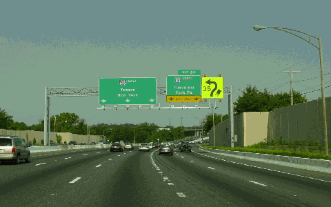
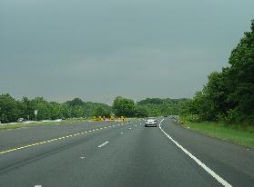
This 2004 photo shows the Inner Loop of the Baltimore Beltway (I-695 eastbound) approaching EXIT 24 (I-83 / Baltimore-Harrisburg Expressway) in Timonium. (Photo by Jim K. Georges.)
|
|
|
|
|
|
|
|
|
 |
|
|
|
|
 |
|
|
|
|
|
|
|
|
|
51.5 miles (82.8 kilometers)
1951-1977
|
|
|
|
|
|
|
|
|
|
|
|
|
|
 |
|
|
|
|
|
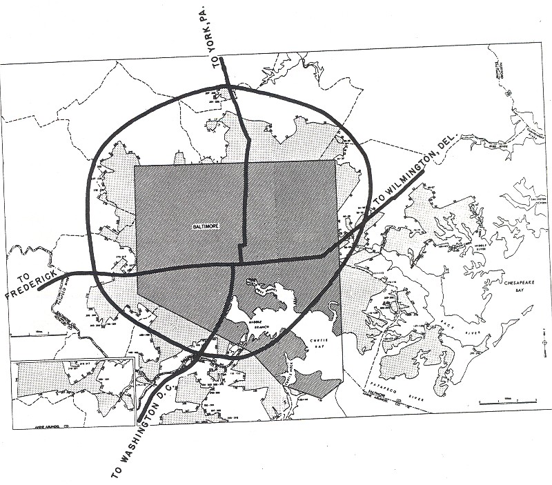
EARLY PLANNING AND CONSTRUCTION: The "Baltimore County Beltway" -- as it was called in its early years -- was conceived in 1949 by the Baltimore County Planning Commission as a 30-mile-long semi-circle around the outskirts of Baltimore City. The four-lane beltway, which began life as a county project, was to be the second controlled-access highway in the Baltimore area after the Baltimore-Washington Parkway.
|
|
|
|
|
|
|
|
|
|
|
|
|
|
Work began on the Baltimore Beltway in 1951. The initial segment, which stretched approximately one half-mile from EXIT 7 (MD 295 / Baltimore-Washington Parkway) to EXIT 8 (MD 168 / Nursery Road) in Linthicum Heights (Anne Arundel County), opened to traffic the following year upon the completion of the adjoining section of the Baltimore-Washington Parkway.
With progress slow, the state took over the project in 1953. The state financed half the cost of the beltway, with the Federal government picking up the remainder of the estimated $50 million cost. By this time, the project limits had expanded to 35 miles stretching from EXIT 1 (MD 173 / Fort Smallwood Road) to EXIT 35 (US 40 / Pulaski Highway).
The pace of construction picked up in 1955 as construction began on the following sections:
|
|
|
|
|
|
|
|
|
|
|
|
|
|
|
|
|
A 1.85-mile-long section was built from EXIT 4 (I-97 / MD 3 / Glen Burnie Bypass) in Glen Burnie to EXIT 7 (MD 295) in Linthicum Heights. This section included connecting ramps to the Glen Burnie Bypass, which also was under construction at this time. However, it also had a sub-standard feature: an at-grade intersection at MD 170 (Camp Meade Road). This intersection did not become a grade-separated interchange until the present-day EXIT 6 was built in 1967.
|
|
|
|
|
|
|
|
|
|
|
|
|
|
|
|
|
|
A 3.7-mile-long section was built from EXIT 23 (MD 25 / Falls Road and I-83 / Jones Falls Expressway) to EXIT 27 (MD 146 / Dunlaney Valley Road). This section included ramps to the Baltimore-Harrisburg Expressway (I-83 NORTH) at EXIT 24, which was under construction at the time, and to the Jones Falls Expressway (I-83 SOUTH) at EXIT 23, which was still in the planning stages at the time.
Both sections were completed in 1958, shortly after the Baltimore Beltway became eligible for Interstate funding (under the 90-10 Federal-state formula) and received the I-695 designation.
|
|
|
|
|
|
|
|
|
|
|
|
|
|
|
|
|
|
|
|
 |
|
|
|
|
|
|
|
|
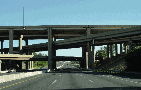
This 2004 photo shows the Inner Loop of the Baltimore Beltway (I-695 northbound) at EXIT 16 (I-70) in Woodlawn. The four-level "stack" interchange carries far less traffic than was anticipated because I-70 ends abruptly two miles east of this interchange; it was not completed in Baltimore and to I-95. (Photo by Jim K. Georges.)
|
|
|
|
|
|
|
|
|
|
|
|
|
|
|
|
|
|
|
|
THE INTERSTATE ERA: The infusion of Interstate highway funds placed the Baltimore Beltway, which had been scheduled for completion originally by 1965, on the fast track to completion. The remaining sections of the original 35-mile project were opened as follows:
1959: EXIT 8 (MD 168) in Linthicum Heights north to EXIT 15 (US 40 / Baltimore National Pike) in Catonsville; 8.3 miles.
|
|
|
|
|
|
|
|
|
|
|
|
|
|
1959: EXIT 34 (MD 7 / Philadelphia Road) in Rosedale to Race Road (just beyond EXIT 35 for US 40 / Pulaski Highway) in Essex; 0.5 mile. (I-695 traffic bound for Essex and the Back River peninsula was dumped onto Race Road until 1973, when the current I-695 / MD 702 interchange was opened to traffic.)
1960: EXIT 27 (MD 146) east to EXIT 29 (MD 542 / Loch Haven Boulevard) in Towson; 2.05 miles.
November 1960: EXIT 21 (MD 129 / Park Heights Avenue and Stevenson Road) in Pikesville to EXIT 23 (I-83 / Jones Falls Expressway) in Tinomium; 3.7 miles.
December 1960: EXIT 15 (US 40) in Catonsville to EXIT 18 (MD 26 / Liberty Road) in Woodlawn; 4.45 miles.
March 1961: EXIT 29 (MD 542) in Towson to EXIT 32 (US 1 / Belair Road) in White Marsh; 3.95 miles.
June 1961: EXIT 18 (MD 26) in Woodlawn to EXIT 21 (MD 129) in Pikesville; 3.55 miles.
July 1962: EXIT 3 (MD 2 / Ritchie Highway) to EXIT 4 (I-97 / MD 3) in Glen Burnie; 0.5 mile. (The MD 3 "mainline" - which formerly served as a continuation of the beltway - exited and entered the beltway in the median.)
July 1962: EXIT 32 (US 1) in White Marsh to EXIT 34 (MD 7) in Rosedale; 2.7 miles. This section included ramps to I-95 (John F. Kennedy Memorial Highway), which was under construction at the time.
The original 35 miles of the four-lane Baltimore Beltway was built at a cost of $60 million, or 50 percent more than the 1955 estimate. When it opened, the beltway had only one section with more than four lanes: the 1.4-mile-long segment between the two sections of I-83 had six lanes. This short beltway segment through Tinomium has overlapping I-695 and I-83 designations.
|
|
|
|
|
|
|
|
|
|
|
|
|
|
|
|
|
 |
|
|
|
|
|
|
|
|
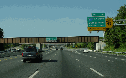
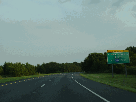
This 2004 photo shows the Outer Loop of the Baltimore Beltway (I-695 westbound / southbound) approaching EXIT 19 (I-795 / Northwest Expressway) in Pikesville. I-795 and the Metro extension to Owings Mills (carried by the trestle ahead) were built during the mid-1980s. (Photos by Jim K. Georges.) Stub ramps for a proposed cloverleaf with the Northwest Expressway were built at this location in the early 1960s, but with the cancellation of the expressway south of I-695, the interchange was reconfigured into its current "directional-T" setup in the 1980s. (Photo by Jim K. Georges.)
|
|
|
|
|
|
|
|
|
|
|
|
|
|
|
|
|
|
|
|
|
|
|
|
|
|
|
|
|
|
COMPLETING THE LOOP: As the original beltway was being completed, officials devised two plans to extend the route to the south and east. Because it was not included in the state's Interstate highway plans, the beltway extension received the MD 695 designation.
One plan had the beltway extension continuing south along its current alignment ("Windlass-Patapsco"), but veering south at EXIT 39 (MD 151 / North Point Boulevard) along Merritt Boulevard, which is a four-lane surface arterial through Dundalk. This alignment was to have had its terminus at Sollers Point Road and did not include an outer crossing of Baltimore Harbor.
|
|
|
|
|
|
|
|
|
|
|
|
|
|
Another plan had MD 695 continuing southeast along the current alignment of MD 702 (Southwest Expressway / Boulevard) and Back River Neck Road, then veering southwest near Essex Skypark Airport to a new bridge over the Back River to the Patapsco Freeway. (The wide landscaped median between EXIT 41 and EXIT 42) was to be for the interchange between the original extension and the Patapsco Freeway.) MD 695 was to depart the Patapsco Freeway alignment at EXIT 42 (MD 151) and continue west across Baltimore Harbor, but as a tunnel (not as the current Key Bridge). MD 695 was to continue west to the existing terminus at MD 2 with an interchange for the Arundel Expressway (MD 10).
By 1973, two pieces of the Baltimore Beltway extension fell into place:
EXIT 2 (MD 10 / Arundel Expressway) to EXIT 3 (MD 2) in Glen Burnie. This 1.3-mile-long, four-lane section of the beltway, on which construction began in 1970, was built in conjunction with the initial section of the Arundel Expressway. Mainline stubs and part of an unused underpass hint at a northerly extension of MD 10 into Baltimore.
EXIT 35 (US 40) in Rosedale to EXIT 39 (MD 151) in Dundalk. Construction of this 3.45-mile-long, four-lane section began in 1965, but it did not open until the early 1970's. (The short distance between EXIT 35 and EXIT 36 was built with six lanes, however.) It was not originally part of the Baltimore Beltway, but actually comprised parts of three partially-built freeways: the Patapsco Freeway from EXIT 39 north to milepost 37 (where there was to have been an EXIT 37 for a westerly extension of the Windlass Freeway and where a sharp 90-degree turn makes it the least safe section on the beltway, particularly for trucks), the Windlass Freeway (MD 149) from milepost 37 to EXIT 36 (MD 702 / Southeast Expressway), and the Southeast Expressway from EXIT 36 to EXIT 35 (US 40). The cancellation of the "Southeast-Back River" alignment of MD 695 during the 1970's necessitated the use of the "Windlass-Patapsco" alignment, which was built for use for those freeways. Upon completion of this segment, the connection to Race Road in Essex (near the current EXIT 36) was closed off, and Race Road was turned into a cul-de-sac.
The final 11 miles of the Baltimore Beltway were completed on March 23, 1977 with the completion of the Francis Scott Key Bridge and its approaches. Although the bridge had a four-lane capacity, the bridge's three-mile-long southern approach and 3.5-mile-long northern approach were built with only two lanes (one lane undivided in each direction). The two-lane approaches were constructed in anticipation of a two-lane tunnel, but the Maryland Transportation Authority (MdTA), which operates the Key Bridge, decided to build a four-lane bridge instead in 1972 after construction bids for the proposed tunnel were much higher than expected.
|
|
|
|
|
|
|
|
|
|
|
|
|
|
 |
|
 |
|
|
|
|
|
|
|
 |
|
|
|
|
|
Evidence of unfinished interchanges can be found along the Baltimore Beltway (I-695) in the following photos, beginning from the upper left:
EXIT 36 (ramps to unbuilt MD 149 / Windlass Freeway east)
milepost 37 (stub to unbuilt MD 149 / Windlass Freeway west)
between EXIT 41 and EXIT 42 (wide median for unbuilt freeway across Back River)
(2004 photos by Jim K. Georges.)
|
|
|
|
|
|
|
|
|
|
|
|
|
|
|
|
|
|
|
|
|
|
|
FROM FOUR LANES TO SIX (AND EIGHT): Almost immediately from the opening of the original 35 miles in the early 1960s, the average section of the Baltimore Beltway carried approximately 45,000 vehicles per day (AADT). Work began in 1964 on a three-year, $15 million project to widen the original 35 miles between EXIT 3 (MD 2) and EXIT 35 (US 40) to six lanes. Although all bridges over the beltway were planned to accommodate six lanes underneath, 18 of the bridges carrying the beltway itself - which were built in the 1950s with only four lanes because of budget constraints - were widened to six lanes in this project, which was completed in late 1967.
|
|
|
|
|
|
|
|
|
|
|
|
|
|
During the mid-to-late 1990s, the Maryland State Highway Administration (SHA) widened the existing six-lane beltway to eight lanes from EXIT 16 (I-70) to EXIT 24 (I-83 / Baltimore-Harrisburg Expressway). Construction crews also added a fourth travel lane on the inner loop of I-695 (northbound) from EXIT 11 (I-95) to EXIT 13 (MD 144 / Frederick Road) during this time; the SHA crews returned between 2002 and 2005 to build the fourth travel lane on the outer loop (southbound).
The SHA plans a $282 million widening of I-695 from EXIT 13 (MD 144) to EXIT 16 (I-70), and a $261 million widening from EXIT 24 (I-83 / Baltimore-Harrisburg Expressway) to EXIT 31 (MD 147 / Harford Road). These projects, which would widen the beltway from six to eight lanes, are slated for completion after 2025. Funds have yet to be allocated for these projects.
FROM TWO LANES TO FOUR: Perhaps the most critical widening job was the upgrade of the northern and southern approaches from their "super-2" configurations. After it opened in 1977, the Key Bridge quickly became an alternate route for trucks that exceeded the height requirements of the Harbor Tunnel (and later the Fort McHenry Tunnel). The mix of heavy traffic and the lack of adequate capacity and median separation was a glaring safety hazard that required corrective action.
The first section to be upgraded was the three-mile-long southern approach to the Key Bridge, including the construction of a two-lane parallel drawbridge to the existing drawbridge over Curtis Creek. This upgrade was built between 1980 and 1983.
Widening of the 3.5-mile-long Key Bridge northern approach did not begin until 1996. When the two-lane northern approach was originally built in the 1970s, it was constructed as a long viaduct over the many streets and railroad spurs that served the busy Bethlehem Steel plant at Sparrows Point. With activity at the plant declining significantly over the years, the SHA decided that fewer road and rail crossings were necessary and decided to replace the two-lane viaduct with a four-lane surface freeway. This work also required the reconstruction of EXIT 43 (MD 157 / Peninsula Expressway) and EXIT 44 (Broening Highway). The project was completed in 2000.
The 7.4 miles of beltway between EXIT 36 (MD 702) in Essex and EXIT 42 (MD 151) in Sparrows Point remain the only sections of beltway to remain in their original construction state of four lanes.
Interestingly, the I-695 designation began to appear on the former MD 695 sections of the beltway in 1988, nearly a decade before construction began on the upgrade of the Key Bridge northern approach.
A WIDER BELTWAY WITH HO/T LANES: With traffic counts on many sections of the Baltimore Beltway over 200,000 vehicles per day and forecasts of 270,000 vehicles per day by 2030, discussions on roadway widening have focused in recent years on the construction of HOV lanes. In 2004, the Maryland SHA confirmed long-term plans to add HOV lanes to I-695. The HOV lanes would have an "HO/T" feature that would allow single-occupant vehicles to use the lanes at a variable toll, which would be collected at highway speeds.
|
|
|
|
|
|
|
|
|
|
|
|
No construction timetables or cost estimates were provided on the HO/T lanes, but such plans likely would be similar to those being drafted for the Capital Beltway (I-495 and I-95). The I-695 setup likely would comprise either six general-use and four HO/T lanes (a 3-2-2-3 lane setup), or eight general-use and two HO/T lanes (a 4-1-1-4 lane setup). These lanes are envisioned as part of a statewide network of express toll lanes.
|
|
|
|
|
|
|
 |
|
|
|
|
|
|
|
|
|
|
A NEW INTERCHANGE WITH I-95: As part of the Maryland Transportation Authority's (MTA) project to rebuild I-95 northeast of Baltimore, the state plans is rebuilding EXIT 33 (I-95) as a multi-level "stack" interchange that would eliminate left-lane exits and entrances along the main roadways (as well as the brief carriageway "crossovers" on both I-95 and I-695). The $830 million I-95 project began in 2006 and was completed in 2011.
|
|
|
|
|
|
|
|
|
|
|
|
|
|
|
 |
|
|
|
|
|
|
|
|
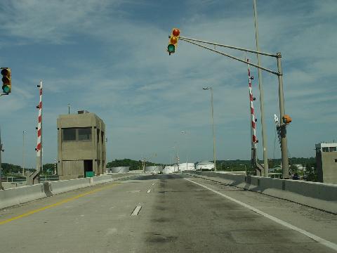
This 2004 photo shows the Inner Loop of the Baltimore Beltway (I-695 westbound) over the Curtis Creek drawbridge. (Photo by Jim K. Georges.)
|
|
|
|
|
|
|
|
|
|
|
|
|
|
 |
|
|
|
|
|
The eight-lane widening on I-695 should be extended southeast to EXIT 4 (I-97 / MD 3 / Glen Burnie Bypass) and northeast to EXIT 33 (I-95 / John F. Kennedy Memorial Highway).
|
|
|
|
|
|
|
|
|
|
|
|
|
|
|
|
|
|
|
|
|
 |
|
|
|
 |
|
|
|
|
|
SOURCES: "Beltway Report," The Baltimore Sun (3/25/1958); "Beltway: East Side, West Side, All Around Town" by R. P. Harriss, The Baltimore News-American (5/04/1958); "Unit Opened on Beltway," The Baltimore Sun (12/15/1958); "Buckling the Belt," The Baltimore Sun (10/05/1960); "SRC Awards Final Contracts for Beltway, Completion Expected in Summer of '62" by Philip Evans, The Baltimore Sun (2/01/1961); "Beltway, State's Safest Major Highway, Is One Year Old" by Edwin Hirschmann, The Baltimore Sun (8/07/1963); "Baltimore Is Busy Widening Its Own Beltway To Beat Congestion" by Fred Brack, The Washington Post (10/13/1966); "20-Year Highway Needs Study," Maryland State Roads Commission (1968); "State Primary Highway System," Maryland Department of Transportation (1972); "Sun Q&A: Stephen Kiehl on Baltimore Beltway" by Stephen Kiehl, The Baltimore Sun (4/27/2004); Maryland State Highway Administration; Scott Kozel; Alex Nitzman; Scott Oglesby; Mike Pruett; C.C. Slater; Alexander Svirsky; William F. Yurasko.
I-695 shield by Ralph Herman.
Lightposts by Millerbernd Manufacturing Company.
HOV lane sign by C.C. Slater.
|
|
|
|
|
|
|
|
|
|
|
|
|
|
|
|
 |
|
|
|
|
|
|
|
|
|
|
|
|
|
|
|
BALTIMORE BELTWAY CURRENT TRAFFIC CONDITIONS:
|
|
|
|
|
|
|
|
|
|
|
 |
|
|
|
|
|
BALTIMORE BELTWAY VIDEO LINKS:
|
|
|
|
|
|
|
|
|
|
|
|
 |
|
|
|
|
|
THE EXITS OF METRO WASHINGTON-BALTIMORE:
Baltimore Beltway (I-695) exit list by Steve Anderson.
|
|
|
|
|
|
|
|
|
|
|
 |
|
|
|
|
|
|
|
|
 |
|
|
|
|
|
|
|
|
|
|
|
|
Site contents © by Eastern Roads. This is not an official site run by a government agency. Recommendations provided on this site are strictly those of the author and contributors, not of any government or corporate entity.
|
|
|
|
|
|
|
|
|
|