 |
|
|
|
|
|
|
|
|
|
|
|
|
|
|
|
|
|
|
|
|
|
|
|
|
|
|
|
|
|
|
|
|
|
|
|
|
|
|
|
|
|
|
|
|
|
|
|
|
|
|
|
|
|
|
|
|
|
|
|
|
|
|
|
|
|
|
|
|
|
|
 |
|
|
|
|
 |
|
 |
|
|
|
|
|
|
|
|
|
|
|
|
|
|
|
|
 |
|
|
|
|
|
|
|
|
|
|
|
|
|
|
|
 |
|
|
|
|
|
|
|
|
|
|
|
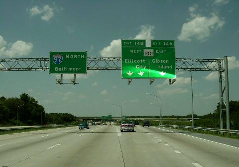
This 2004 photo shows the northbound I-97 at EXIT 14 (MD 100 / Paul T. Pitcher Memorial Highway) in Glen Burnie. This section of I-97, which was built originally in the 1950s as part of the Glen Burnie Bypass, was widened and upgraded to Interstate standards in the early 1990s. (Photo by Jim K. Georges.)
|
|
|
|
|
|
|
|
|
 |
|
|
|
|
 |
|
|
|
|
|
|
|
|
|
17.6 miles (28.4 kilometers)
1955-1993 (original construction)
1994-1997 (reconstruction of original Glen Burnie Bypass)
|
|
|
|
|
|
|
|
|
|
|
|
|
|
 |
|
|
|
|
|
THE ORIGINAL GLEN BURNIE BYPASS: Designed to relieve congestion along Crain Highway (MD 3, then designated US 301) and Ritchie Highway (MD 2), the Glen Burnie Highway was conceived as a spur of the Baltimore Beltway (I-695) and the Harbor Tunnel Thruway (I-895). The Maryland State Roads Commission (SRC) built the four-lane highway between 1954 and 1957 at a cost of $4 million. There were six grade separations along the six-mile-long bypass.
|
|
|
|
|
|
|
|
|
|
|
|
|
|
|
|
|
|
|
|
|
A NEW INTERSTATE TO ANNAPOLIS: As early as 1968, Maryland officials submitted a Baltimore-to-Annapolis route to the Federal Highway Administration (FHWA) for inclusion in the Interstate highway system when funds became available for an additional 1,500 miles nationwide. Although the FHWA denied this initial request in 1970, the Maryland State Highway Administration (SHA) - the successor to the SRC - made additional requests for inclusion throughout the decade.
Meanwhile, the original four-lane Glen Burnie Bypass had long outlived its usefulness. From the end of the Glen Burnie Bypass south to Bowie, MD 3 was a four-lane divided highway with numerous traffic lights for local streets and curb cuts for local businesses. According to records obtained by The Baltimore Sun, 25 people killed along this stretch between 1971 and 1975.
|
|
|
|
|
|
|
|
|
|
|
|
In 1972, the SHA the conversion of the four-lane divided arterial and expansion of the existing Glen Burnie Bypass. Upon completion, MD 3 would be a six-lane freeway from I-695 in Glen Burnie south to US 50 / US 301 (John Hanson Highway) in Bowie. The state estimated the cost of this conversion at $85 million. In 1975, the FHWA approved the transfer of highway funds from other projects to this project, but by this time the cost of the conversion had risen to $118 million. With the priority given to the completion of Baltimore's I-95, I-83, and I-695, the earliest work would commence on MD 3 was 1983.
|
|
|
|
|
|
|
|
|
|
|
|
|
|
|
|
|
|
As congestion grew along the Baltimore-to-Annapolis corridor, the SHA developed the "Baltimore-Annapolis Transportation Study" (BATS) in 1978. The study tested a corridor west of the Severn River (expanded MD 3-proposed MD 32 extension) against an eastern corridor (MD 10 / Arundel Expressway). It found the western corridor would not only local and long-distance better than the eastern corridor, but also result one-third the level of displacements (35 homes and 20 businesses).
With additional Interstate transfer funds made available by the cancellation of highways in the Baltimore and Washington areas, the SHA received its big break: on June 11, 1979, the FHWA formally announced plans for the new Interstate 97. By this time, the freeway's cost had risen to $225 million.
According to the original 1979 plan, I-97 was to take the following route:
Beginning at the ramps to I-895 and continuing south along the route of the existing Glen Burnie Bypass to the current EXIT 12 (Business MD 3 / Crain Highway) in Glen Burnie, the existing four-lane freeway was to be widened to a minimum of six lanes and brought to current Interstate design and safety standards.
From EXIT 12 south to current EXIT 7 (MD 32 / Patuxent Freeway and MD 3 south) in Millersvillle, three southbound lanes were to be built on new right-of-way west of the existing highway, while the existing southbound lanes would be widened from two to three lanes and converted for northbound use. The existing northbound lanes would be used for local access.
From EXIT 7 southeast to the current southern terminus at US 50 / US 301 in Annapolis, the four-lane I-97 was to be built on new right-of-way. This section was planned to have been a southeasterly extension of the Patuxtent Freeway (MD 32).
The original plan had I-97 looping back west along US 50 / US 301 to the Capital Beltway (I-95 / I-495). The existing four-lane US 50 was to be expanded to six lanes and upgraded to Interstate standards. The I-97 designation along this segment was dropped in 1983 and replaced by the I-68 designation. When Interstate funds became available for the National Freeway (former US 48) in western Maryland, the I-68 designation was replaced by the secret I-595 designation in 1989.
|
|
|
|
|
|
|
|
|
|
|
|
|
|
|
|
|
|
|
 |
|
|
|
|
|
|
|
|
|
|
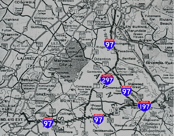
This 1979 state highway map shows the originally proposed route of I-97, which headed back west from Annapolis along US 50 to the Capital Beltway (I-95 and I-495). It also shows the routings of I-197 and I-297. (Map supplied by Stephen Summers.)
|
|
|
|
|
|
|
|
|
|
|
|
|
|
|
|
|
|
I-97 AND FRIENDS: The original I-97 plan included two spur routes:
|
|
|
|
|
|
|
|
|
|
|
|
I-197: Extending four miles from the current southern terminus of I-97, I-197 was to be routed along four miles of US 50 / US 301 east to MD 70 (Rowe Boulevard), just west of the Severn River Bridge in Annapolis. Like the US 50 segment to the west, the existing four-lane US 50 was to be expanded to six lanes and upgraded to Interstate standards. The I-197 designation was dropped in favor of I-68 in 1983, and by the secret I-595 designation in 1989.
|
|
|
|
|
|
|
 |
|
|
|
|
|
|
 |
|
|
|
|
|
I-297: This 7.7-mile-long loop was to continue south along MD 3 from I-97 EXIT 7 (MD 3 / MD 32) in Millersville to I-595 / US 50 in Bowie. Most of four-lane MD 3 along this stretch was to have been upgraded to Interstate standards, but in areas where this was not possible (such as business districts), the four-lane I-297 would have been built on a new right-of-way west of the existing MD 3. However, the SHA shelved this route in 1983 amid intense opposition.
|
|
|
|
|
|
|
|
|
|
|
|
|
|
MORE THAN A DECADE OF CONSTRUCTION: Construction of the new I-97 began in 1984. Five years later, the first section of I-97 from I-595 / US 50 / US 301 in Annapolis to just north of EXIT 7 in Dorrs Corner (near the intersection of old MD 3 / Veterans Highway and MD 178 / Generals Highway). This included a partial interchange at EXIT 5 (MD 178) and a full interchange at EXIT 7 (MD 32 / Patuxtent Freeway and MD 3 / Crain Highway).
Between 1989 and 1993, I-97 was built from just north of EXIT 7 to EXIT 12 (Business MD 3 / New Cut Road) in Glen Burnie. Following the 1979 plan, the southbound lanes were built on a new right-of-way first; traffic was diverted onto the new southbound lanes while the northbound lanes were rebuilt to minimize disruption. Beginning in 1994, the SHA upgraded the old Glen Burnie Bypass from EXIT 12 north to EXIT 18 (I-895) in Brooklyn Park, diverting traffic onto opposing carriageways as each section was rebuilt. By the time the I-97 project was completed in late 1997, its cost had risen to $450 million, about six times the 1972 projection.
According to the SHA, I-97 carries approximately 105,000 vehicles per day (AADT) from I-695 south to MD 32 and 75,000 vehicles per day from MD 32 south to I-595 / US 50.
|
|
|
|
|
|
|
|
|
|
|
|
|
|
|
 |
|
|
|
|
|
|
|
|
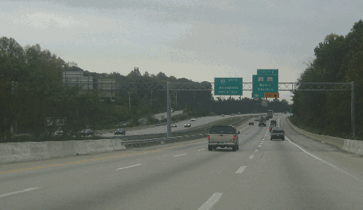
This 2005 photo shows the southbound I-97 approaching EXIT 7 (MD 3 and MD 32) in Millersville. (Photo by Steve Anderson.)
|
|
|
|
|
|
|
|
|
 |
|
|
|
|
|
|
|
|
|
 |
|
|
|
 |
|
|
|
|
|
|
|
WASHINGTON'S EASTERN BYPASS: Since the 1950s, highway officials in Maryland and Virginia had long-standing plans for an Outer Beltway, but the proposal fell out of favor by the 1970s as environmental and community blocked sections of the beltway even after some rights-of-way were purchased. Nevertheless, officials returned in the 1980s with more ambitious bypass plans extending approximately 20 to 30 miles east and west of the National Mall.
The 1990 Washington Bypass Study developed by the SHA and the Virginia Department of Transportation) proposed two alternatives for the Eastern Bypass:
The route would follow US 301 south to Waldorf, then veer west toward I-95 with a new Potomac River crossing between Chicamuxen, Maryland and Dumfries, Virginia. Not including the seven-mile-long MD 3 conversion from Millersville to Bowie (former I-297 proposal), the 61-mile-long alternative from I-595 / US 50 south to I-95 in Dumfries was estimated to cost $1.1 billion in 1990 dollars.)
The alternate routing would follow US 301 in its entirety from I-595 / US 50 to Bowling Green, Virginia, including the construction of a parallel or rebuilt Henry Nice Memorial Bridge. At Bowling Green, the proposed route would continue along VA 207 to I-95 in Carmel Church. Not including the seven-mile-long MD 3 conversion, the 93-mile-long alternative from I-595 / US 50 south to I-95 in Carmel Church was estimated to cost $1.4 billion in 1990 dollars.)
There was speculation that I-97 was to be reserved for a future Eastern Bypass, but the FHWA never approved this proposal formally. Through much of the 1990s, discussion shifted to a Western Bypass as opposition mounted in Anne Arundel County, though by the new millennium even the Western Bypass mustered enough opposition mostly because of the potential location of the Potomac River crossing in an environmentally sensitive area.
|
|
|
|
|
|
|
|
|
|
|
|
|
|
 |
|
|
|
|
|
MULTIPLEX WITH I-895: The I-97 designation should be extended north through the Harbor Tunnel to the I-95 / I-895 junction at the Baltimore City line. In conjunction with a proposed I-97 extension south along US 301 to Virginia, the I-97 designation would provide motorists a through traffic route to bypass I-95 congestion in Baltimore and Washington.
THE BALTIMORE-RICHMOND BYPASS (AND A NEW I-297): I-97 should be diverted onto the MD 3 / US 301 corridor south of EXIT 7 (MD 32 / Patuxtent Freeway). The existing corridor would be rebuilt to Interstate standards, and where this is not possible, a parallel roadway would be built on new rights-of-way. The new "I-97 south" corridor would have at least three through lanes in each direction. South of John Hanson Highway (I-595 / US 50), the new I-97 would follow one of two alternatives forwarded in the 1990 Washington Bypass Study.
|
|
|
|
|
|
|
|
|
|
 |
|
|
|
|
|
|
|
|
|
|
|
|
Upon completion of the I-97 Washington Bypass, the existing seven-mile-long section of I-97 from I-595 / US 50 north to MD 32 would become part of the new I-297. (The Patuxtent Freeway, which now is designated MD 32, would be re-designated I-297 at least as far as west I-95 and possibly as far north as the unfinished section linking to I-70.
|
|
|
|
|
|
|
|
|
|
|
|
|
|
|
|
|
|
|
|
|
|
|
 |
|
|
|
|
|
SOURCES: "McKeldin Breaks Ground for Glen Burnie Bypass," The Washington Post (8/27/1954); "20 Year Highway Needs (1977-1996)," Maryland State Highway Administration (1972); "US Funds Widening of Route 3 to Six Lanes" by Mike Powell, The Baltimore Sun (7/27/1975); "State Backs Freeway on Route 3, Rules Out Rail Line to Airport" by Karen Hosler, The Baltimore Sun (6/12/1979); "Baltimore-Annapolis Route Chosen for New Interstate," The Washington Post (6/12/1979); "Bypass Could Become the Battle of the Decade" by Stephen C. Ferr, The Washington Post (5/14/1990); Washington Bypass Study, Maryland Department of Transportation and Virginia Department of Transportation (1990); "Major Transportation Milestones in the Baltimore Region Since 1940," Baltimore Metropolitan Council (2006); Scott Kozel; Scott Oglesby; Mike Pruett; Alexander Svisrky.
I-97 shield by Ralph Herman.
I-197 and I-297 shields by Scott Colbert.
Lightpost by Millerbernd Manufacturing Company.
|
|
|
|
|
|
|
|
|
|
|
|
|
|
|
|
|
|
|
|
|
|
|
|
|
|
|
|
|
|
|
|
|
|
|
|
 |
|
|
|
|
|
|
|
|
 |
|
|
|
|
|
THE EXITS OF METRO WASHINGTON-BALTIMORE:
I-97 (Maryland) exit list by Steve Anderson.
|
|
|
|
|
|
|
|
|
|
|
 |
|
|
|
|
|
|
|
|
|
|
|
|
Site contents © by Eastern Roads. This is not an official site run by a government agency. Recommendations provided on this site are strictly those of the author and contributors, not of any government or corporate entity.
|
|
|
|
|
|
|
|
|
|