
|
|
||
|
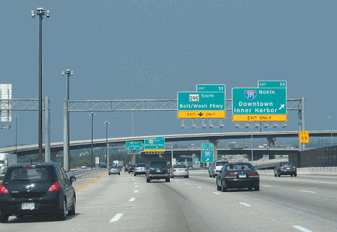
This 2010 photo shows the southbound I-95 at EXIT 53 (I-395 / Cal Ripken Way) in Baltimore. (Photo by Steve Anderson.) |
||
|
Length: |
||
|
11.9 miles (19.2 kilometers) |
||
|
EARLY PLANNING FOR BALTIMORE'S EXPRESSWAYS: In 1942, with the U.S. involvement in World War II well underway, officials in Baltimore developed plans for an express bypass of the city. The city proposed two separate routes: a tunnel under Franklin Street (which later became US 40 / Franklin-Mulberry Expressway) and an elevated expressway above Pratt Street. Both routes were to have an east-west orientation. The Baltimore City Planning Commission (BCPC) approved this plan in 1943, though this decision was non-binding. |
||
|
The following year, Robert Moses, who was the master planner for New York's arterial highway system, was hired as a consultant by the BCPC to develop its plans further. Although the plans contemplated parkway-like design treatment for the proposed East-West (Pratt) Expressway and the Franklin (Mulberry) Expressway, and Moses defended his designs by stating they would help defeat urban blight, the BCPC ultimately rejected Moses' plans. |
||
|
The Smith Report gained acceptance within the planning community, but local leaders never really warmed to the plan, citing concern that the East-West Expressway in particular would be routed either through downtown Baltimore (via the Inner Harbor alignment) or north of the central business district (via the Biddle Street alignment, which was one mile north of the Inner Harbor alignment). Even without definitive alignments for two of the three routes, the BPR still approved all three routes submitted by the state and city--the East-West, Southwest, and Jones Falls Expressways--as part of the Interstate highway system in 1956. |
||
|
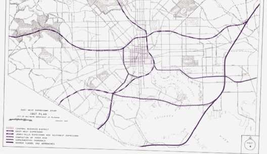
This 1957 photo shows proposed routings for the East-West Expressway, which includes (1) a preferred routing along the edge of the Inner Harbor; (2) a southern alternate routing that was the basis of what later became the "Fort McHenry" alignment of today's I-95; (3) a northern alternate routing that would have taken I-95 north of downtown Baltimore and continued straight west as I-70N; and (4) an inner loop freeway encircling downtown Baltimore. The Jones Falls Expressway (I-83), which was to enter the city from the north, was included in all alternatives. (Map from City of Baltimore-Department of Planning archives.) |
||
|
THE 10-D PLAN; "D" IS FOR DARLING: In 1958, Baltimore mayor Thomas D'Alesandro, Jr. named Phillip Darling of the city's planning department. Darling saw the threat posed by the construction of the Baltimore Beltway (I-695) in luring business out of the city, and thought it was necessary that the city respond by building radial expressways to not only address the needs of commuters and shippers, but also help the city retain and attract business. |
||
|
|
||


|
|
||

|
|
||
|
The 10-D "harbor route" alignment was preferred over the north-of-downtown alignment proposed in 1957, as it would have required the removal of 3,187 dwelling units, four business buildings, and no churches for the 10-D alignment, versus 5,582 dwelling units, 18 business buildings, and six churches for the northerly alignment. The cost difference between the 10-D and northerly alternatives was nominal; the estimated cost was about $225 million for the 10-D alignment, versus $194 million for the northerly alignment. |
||
|
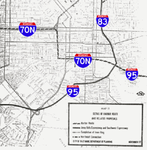
This map shows the original 10-D expressway plan devised by the Baltimore City Department of Planning. Note how I-95, I-70N, and I-83 were to converge at a major interchange at the northeast corner of the Inner Harbor. (Map from City of Baltimore-Department of Planning Archives.) |
||
|
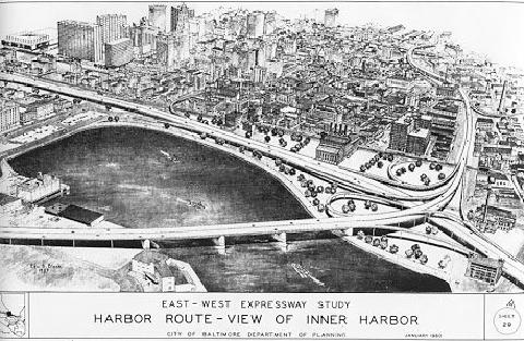
This illustration shows the major interchange between I-95, I-70N, and I-83 that was proposed for the northeast corner of the Inner Harbor under the original 10-D plan. View is toward the northwest. (Map from City of Baltimore-Department of Planning Archives.) |
||
|
AN INITIAL ALTERNATIVE TO 10-D: The city hired a locally-based consortium called Expressway Consultants to review Darling's 10-D proposal. The consortium was comprised of J.E. Greiner Company, which worked on the Baltimore Harbor Tunnel and the William Preston Lane Jr.-Chesapeake Bay Bridge; Remmel, Klepper & Kahl, which worked on the Baltimore Beltway, and Knoerle, Graef, Bender & Asssociates, which worked on the Jones Falls Expressway. |
||
|
The Expressway Consultants alternative addressed concerns about routing the East-West Expressway along the northern edge of the Inner Harbor, including the need to fill in parts of the harbor. However, neither alternative addressed concerns about the effects of the I-95 Inner Harbor bridge and approach viaducts in the Federal Hill and Fells Point neighborhoods. Moreover, neither proposal addressed environmental concerns about the I-70N section of the East-West Expressway through Leakin Park. By the mid-1960s, groups favoring the 10-D proposal and those favoring the Expressway Consultants proposal had reached an impasse. |
||
|
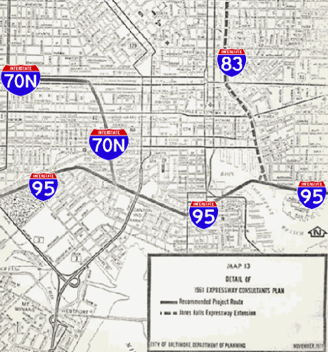
This map shows Expressway Consultants' response to the 10-D plan devised by the Baltimore City Planning Department. Under this plan, I-95 would have avoided downtown Baltimore, while there would have been separate interchanges with I-70N (East-West Expressway) and I-83 (Jones Falls Expressway). (Map from City of Baltimore-Department of Planning Archives.) |
||
|
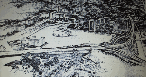
This illustration shows the major interchange between I-95 and I-83 that was proposed for the eastern edge of the Inner Harbor under the Expressway Consultants alternative. View is toward the northwest. (Map from City of Baltimore-Department of Planning Archives.) |
||
|
COLLABORATING FOR A BETTER SOLUTION: In response to concerns expressed by pro-expressway groups and community advocates, the City of Baltimore and the Bureau of Public Roads (later the Federal Highway Administration [FHWA]) collaborated on a new technique of highway planning which included participation by the public in the planning stages of a project and consideration of public comments for proposed plans. This technique is commonplace in modern highway planning, but was a novel concept in the 1960s. |
||
|
What emerged from this collaboration was the Urban Design Concept Associates (UDCA), known internally as the "Concept Team," which was formed in 1966 from Expressway Consultants (which had worked earlier on an alternative to the 10-D plan), two technical consulting firms (Parsons, Brinckeroff, Quade & Douglas and Wilbur Smith & Associates), architects from Skidmore Owings & Merrill, and other experts. In early 1969, the UDCA published their reasoning for developing a new highway plan as follows: |
||
|
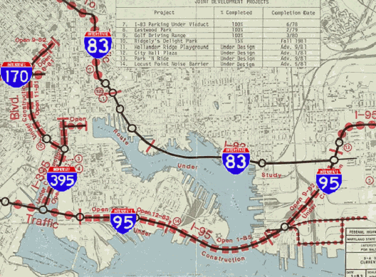
This illustration shows the 3-A expressway system as approved by the Federal government in 1969, with updates through 1981. Although the 3-A system mileage was only half-completed, all of the I-95 mileage was opened in 1985 with the completion of the Fort McHenry Tunnel and immediate approaches. (Map adapted from the original Interstate Division for Baltimore City, 3-A System Current Status Map [1981].) |
||
|
THE SECOND BATTLE OF FORT MCHENRY: In 1970, officials announced plans to build an eight-lane, dual-deck suspension bridge across Baltimore Harbor at the site of the current tunnel. Under the Section 4(f) provisions of the US Department of Transportation Act of 1966, the Fort McHenry National Monument - the site where Francis Scott Key penned the "Star-Spangled Banner" during the Battle of Baltimore in 1814 - was considered a historic site requiring protection. This point was not lost on the residents of the Locust Point, who protested the elevated highway plans for I-95 in a 1971 public hearing. After studies found that the bridge would have deleterious effects on Fort McHenry and the Locust Point peninsula, officials pushed for a tunnel alternative. |
||
|
In April 1974, Mayor William Schaefer made the following announcement concerning the Fort McHenry Tunnel proposal: |
||
|
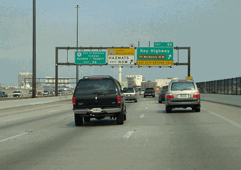
This 2005 photo shows the northbound I-95 approaching EXIT 55 (Key Highway) in the Locust Point neighborhood of Baltimore. The weathering ("corten") steel sign gantry shown here was part of the original construction in the early 1980s and was replaced by 2010. (Photo by Jim K. Georges.) |
||
|
CONSTRUCTION PROGRESSES: In 1971, work began on a short segment of I-95 near the southern boundary of Baltimore City, and the following year, work began on a segment of I-95 near the northern boundary of Baltimore City. Under the 3-A plan, the more northerly segment of I-95 was given a new alignment east of the existing Harbor Tunnel Thruway (now I-895), as it would be designed to serve local traffic, while I-895 served express traffic. |
||
|
AT LONG LAST, I-95 IS COMPLETED THROUGH BALTIMORE: On the afternoon of November 23, 1985, the eight-lane Fort McHenry Tunnel was completed after more than five years of construction, while the completion of the immediate I-95 approaches capped 14 years of construction. When it opened, the Fort McHenry Tunnel was the widest underwater tunnel in the world, a title it still holds today. As construction progressed, the estimated cost had more than doubled to $825 million, but the project was completed under budget at $750 million. Nevertheless, the Fort McHenry Tunnel was the single most expensive project on the Interstate highway system until Boston's $14.5 billion "Big Dig" project of the 1990s and 2000s. |
||
|
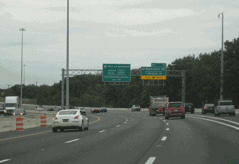
This 2016 photo shows the southbound I-95 approaching EXIT 57 (O'Donnell Street) in Southeast Baltimore. This interchange was to have been the starting point for the Jones Falls Expressway (I-83) under the 3-A expressway plan. The I-83 extension was canceled in the early 1980s. (Photo by Steve Anderson.) |
||
|
MAJOR RECONSTRUCTION: The first major reconstruction project along this segment was a $24 million project to repair and resurface 22 bridges along I-95 from the Fort McHenry Tunnel north to the I-895 junction. Begun in November 2004, the project was completed in October 2006. |
||
|
In April 2017, the MdTA began a $49 million project to reconfigure travel lanes on a four-mile stretch of I-95 north of the Fort McHenry Tunnel. The section between EXIT 57 and EXIT 60 was built with only three continuous through lanes in each direction with merge lanes, but upon completion of the project, four through lanes were provided in each direction. The project was completed in the summer of 2018. |
||
|
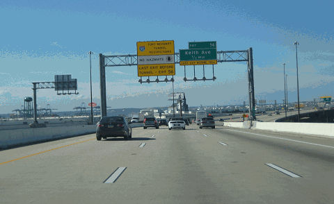
This 2014 photo shows the southbound I-95 approaching EXIT 56 (Keith Avenue) in Southeast Baltimore. (Photo by Steve Anderson.) |
||

|
SOURCES: "Expressway Pool Plan Announced" by Louis O'Donnell, The Baltimore Sun (3/17/1945); "Plans To Push Expressway," The Baltimore Sun (8/07/1947); "Southwest Expressway Plan Mapped" by Joseph Sterne, The Baltimore Sun (12/16/1956); "Schaefer's Road Advice: Give Up Plan" by John E. Woodruff, The Baltimore Sun (8/21/1966); "Route Is Set on East-West Expressway," The Baltimore Sun (10/19/1968); "Group Supports Road Route Rejected by Design Team," The Baltimore Sun (12/08/1968); "Mayor's Route Choice Averts Harbor Span, Bypasses Rosemont" by John B. O'Donnell, Jr., The Baltimore Sun (12/24/1968); Transportation, Environmental, and Cost Summary: An Evaluation of Three Concepts for Expressway Routes in Baltimore City, Urban Design Concept Associates (1968); "City's 3-A Route Wins Approval of US Agency" by John B. O'Donnell, Jr., The Baltimore Sun (1/18/1969); "Report Asks Fund Shift for Bridge" by Kathy Kraus, The Baltimore Sun (10/27/1970); "Locust Point Bridge Spurs Angry Debate" by James D. Dilts, The Baltimore Sun (3/31/1971); "Bill Would Bar I-95 in South Baltimore," The Baltimore Sun (2/26/1972); "Expressway Opponents Tell Why They Switched to Supporting Road" by James D. Dilts, The Baltimore Sun (2/28/1972); "I-95 Projects Are Begun," The Baltimore Sun (11/04/1972); "Mayor Endorses Tunnel Plan for 3A Expressway" by James D. Dilts, The Baltimore Sun (4/08/1974); "The Road Battle at Fort McHenry" by James D. Dilts, The Baltimore Sun (12/08/1974); Baltimore Regional Environmental Impact Study, Alan M. Vorhees and Associates (1974); "Baltimore Will Get Second Harbor Tunnel" by Ben A. Franklin, Jr., The New York Times (1/11/1980); "Fort McHenry Tunnel Set To Open Soon," The Washington Post (9/24/1985); "I-95 Drivers Get Remedy for Harbor Headache" by Susan Schmidt, The Washington Post (11/23/1985); "Tunnel Speeds I-95 Flow Through Baltimore" by Robert D. Hershey, Jr., The New York Times (11/27/1985); "Mainline Construction To Continue on Mainline Interstate 95," WBAL-TV (3/20/2015); Maryland Department of Transportation; Maryland Transportation Authority; Wagman, Inc.; Alex Nitzman; Mike Pruett; Scott Kozel. |
||

|
INTERSTATE 95-MARYLAND (BALTIMORE CITY) LINKS: |
||
|
INTERSTATE 95-MARYLAND (BALTIMORE CITY) CURRENT TRAFFIC CONDITIONS: |
||
|
INTERSTATE 95-MARYLAND (BALTIMORE CITY) VIDEO LINKS: |
||

|
THE EXITS OF METRO WASHINGTON-BALTIMORE: |
||

|
|
||

|
Back to The Roads of Metro Washington-Baltimore home page. |
||
|
Site contents © by Eastern Roads. This is not an official site run by a government agency. Recommendations provided on this site are strictly those of the author and contributors, not of any government or corporate entity. |
||