
|
|
||
|
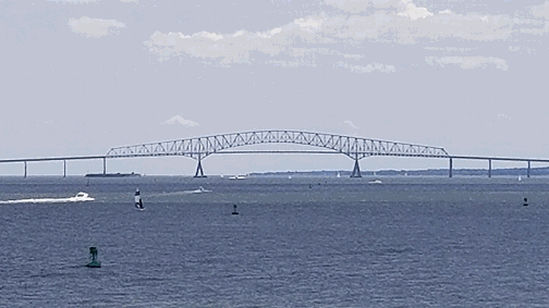
This 2017 photo shows the Francis Scott Key Bridge (I-695) looking south from Fort McHenry National Monument. (Photo by Steve Anderson.) |
||
|
Type of bridge: |
||
|
Continuous truss |
||
|
Click here for news updates from the Maryland Transportation Authority. Click here for news updates from WMAR-TV (ABC Baltimore). |
||

|
PLANNED SINCE THE FIFTIES: As work wound down on the Baltimore Harbor Tunnel (I-895) in 1957, the Maryland State Roads Commission suggested that a second tunnel beneath Baltimore Harbor. Believing such a tunnel could be integrated into the Interstate highway network then under development, the state began location studies for the proposed tunnel. In 1958, the state purchased 17 acres of a 137-acre tract held by the General Services Administration at Hawkins Point, but did not pursue any further action. |
||
|
With the original four-lane Harbor Tunnel exceeding full design capacity at roughly 65,000 vehicles per day (AADT) by 1964 and projections for 1980 at double this level, the State Roads Commission advocated construction of a second four-lane tunnel between Hawkins Point and Sollers Point ahead of a parallel Chesapeake Bay Bridge (US 50 and US 301). Commission Chairman John Funk called the second harbor crossing "a bread-and-butter, 52-weeks a year proposition," while calling the second bay bridge "a four months a year problem." The state estimated the cost of the proposed Outer Baltimore Harbor Crossing, which comprised a four-lane tunnel and approach highways that were to complete the Baltimore Beltway (I-695), at between $150 million and $175 million (in 1964 dollars). |
||
|
Initial test borings were made for the tunnel beneath Baltimore Harbor in 1969, and work on the causeway and viaduct approaches began early in 1970. In July of that year, the State Roads Commission entertained bids for the tunnel. Even given the reduced scope of the project, the relatively high bids on the tunnel project alone - which ranged from $50 million to $60 million - prompted the state to pursue a four-lane bridge alternative. The state received a $19.5 million bid for the bridge's substructure in August 1972, followed by a $30.7 million bid for the superstructure two months later. |
||
|
DESIGN AND CONSTRUCTION: The Maryland Transportation Authority (MdTA), which took over jurisdiction of the state's toll roads and water crossings in 1971, commissioned J.E. Greiner, a leading Baltimore-based engineering design firm (and now part of the URS Corporation), to oversee construction of the bridge. A conventional suspension design was considered for the crossing, but the idea was abandoned over concerns about the cost and size of the anchorages. |
||
|
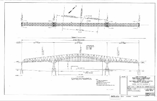
This 1972 blueprint shows the design plan for the superstructure of the "Baltimore Harbor Outer Crossing -- Patapsco River Bridge," later known as the Francis Scott Key Bridge. (Blueprint from the Maryland Transportation Authority archives.) |
||
|
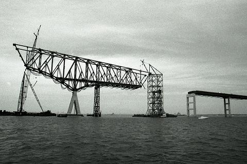
This 1975 photo shows the Francis Scott Key Bridge (I-695) under construction. (Photo from Maryland Transportation Authority archives.) |
||
|
BRINGING THE APPROACHES UP TO INTERSTATE STANDARDS: When they were built between 1970 and 1973, the approaches leading to the Francis Scott Key Bridge were designed under the assumption that there was to be a two-lane tunnel, not a four-lane bridge. This included the 3,379-foot-long drawbridge over Curtis Creek near Hawkins Point (west of the Key Bridge) and the 3,907-foot-long viaduct over Bear Creek near Sparrows Point (east of the Key Bridge). Because these approaches were not up to Interstate standards, along with the fact that the Outer Baltimore Harbor Crossing was not one of the original Interstate routes planned for Baltimore, the completed project received the MD 695 designation. |
||
|
The MdTA built a parallel drawbridge over Curtis Creek for the beltway extension between 1978 and 1981. The completion of this project brought four lanes of traffic capacity on the Baltimore Beltway extension from the Arundel Expressway (MD 10) to the Francis Scott Key Bridge. In the closed position, the Curtis Creek drawbridges provide 60 feet of vertical clearance. The beltway bridge over Curtis Creek parallels the adjacent four-lane MD 173 bridge over Curtis Creek, which also was built during the 1970s. |
||
|
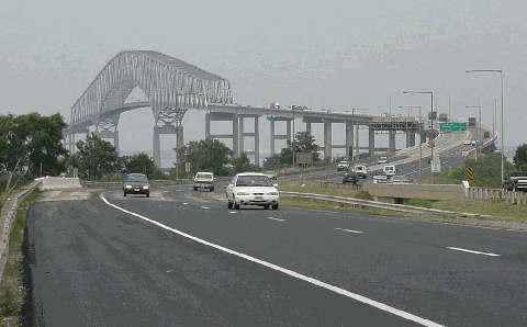
This 2001 photo shows the Francis Scott Key Bridge (I-695) looking east from Hawkins Point. (Photo by Jim K. Georges.) |
||
|
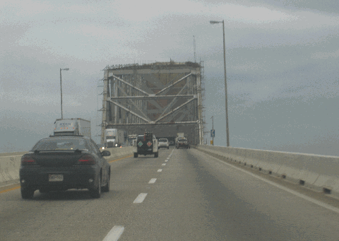
This 2005 photo shows the westbound / inner loop lanes of the Francis Scott Key Bridge (I-695) approaching mid-span. (Photo by Steve Anderson.) |
||
|
A CATASTROPHIC COLLAPSE: At 1:28 AM on March 26, 2024, a 984-foot (300-meter) long Singapore-flagged container vessel, the Dali, struck the western main support of the Key Bridge, sending the entire superstructure and three of the eastern approach girder spans into the Patapsco River. The Sri Lanka-bound container ship, which according to the National Transportation Safety Board (NTSB) was traversing Baltimore Harbor at a speed of 9 MPH, was reported to have lost power twice in the minutes before hitting the bridge. |
||
|
As the vessel lost power, the vessel's crew placed a mayday call to the MdTA Police just two minutes before the vessel struck the bridge, giving the MdTA Police enough time to stop traffic on both approaches. A team of eight construction workers repairing concrete was on the bridge at the time of the collapse. Two workers survived, but six workers perished. |
||
|
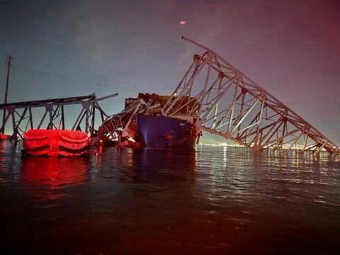
This 2024 photo shows the Francis Scott Key Bridge (I-695) just moments after its catastrophic collapse into the Patapsco River. The crippled Singapore-flagged vessel Dali lies at the bridge's western main pier. (Photo by Baltimore City Fire Department, Truck 6.) |
||
|
This 2024 photo shows the Francis Scott Key Bridge (I-695) just a few hours after its catastrophic collapse into the Patapsco River. The crippled Singapore-flagged vessel Dali lies at the bridge's western main pier. This photo was taken from the Top of the World observatory at Baltimore's World Trade Center. (Photo by Jim Schuyler). |
||

|
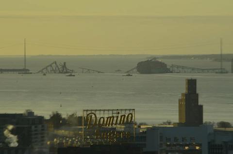
This 2024 photo shows the Francis Scott Key Bridge (I-695) the morning after its catastrophic collapse into the Patapsco River. This photo was taken from Sparrows Point. (Photo by Adam Kukla.) |
||

|
SOURCES: "Baltimore Thinks Ahead to Second Harbor Tunnel," The Washington Post (10/13/1957); "Second Harbor Tube Planned," The Washington Post (5/10/1958); "Second Baltimore Tunnel Urged by Road Chairman," The Washington Post (8/27/1964); "Bonds Sold for Tunnel, Bay Bridge," The Washington Post (10/11/1968); "Maryland Ponders Bid on Harbor Tunnel," The Washington Post (7/25/1970); Baltimore Harbor Outer Crossing: Final Environmental Impact Statement, US Department of Transportation, Federal Highway Administration, and Maryland Transportation Authority (1972); "Worker Crushed by Steel Cable," The Washington Post (5/06/1973); "Delay on Bridge," The Washington Post (8/08/1974); "New Bridge Bypasses the Baltimore Tunnel," The New York Times (3/27/1977); "Terror Threat Ties Up Baltimore Tunnels" by Eric Rich and John Wagner, The Washington Post (10/19/2005); "MdTA Announces Cashless Tolls for Two Bridges in Maryland" by Blair Young, WBAL-TV (9/26/2019); "Six Workers Presumed Dead; Baltimore's Key Bridge Collapses After Container Ship Hits Support Column" by Hayes Gardner and Christine Condon, The Baltimore Sun (3/26/2024); "What To Know About the Francis Scott Key Bridge Collapse" by Emily Mae Czachor, WJZ-TV (3/26/2024); "Port Worker Union President on Bridge Collapse: 'It's Catastrophic for Us'" by Tommie Clark, WBAL-TV (3/27/2024); "Rebuilding Baltimore's Key Bridge Will Likely Take Years, Experts Say" by Tom Jackman and Emily Davies; The Washington Post (3/27/2024); "US Supply Chain Task Force To Discuss Baltimore Bridge Collapse," Reuters (3/27/2024); "Janet Yellen Walks Back Biden's Comments US Taxpayers on Hook for Baltimore Bridge Collapse" by Bradford Betz, Fox Business Network (3/27/2024); "What To Know About the Cargo Ship Dali," The Associated Press (3/28/2024); "Tugboats Left Before Ship Reached Baltimore Bridge; They Might Have Saved It" by Emily Le Coz and Trevor Hughes, USA Today (3/28/2024); "Baltimore Disaster May Be the Largest-Ever Marine Insurance Payout, Lloyd's Boss Says" by Jenni Reid, CNBC (3/28/2024); "Fitch Says Baltimore Bridge Collapse Likely To Be Largest Marine Insurance Claim in History" by Stephen Nakrosis, The Wall Street Journal (3/28/2024); "Maryland Receives $60 Million in Initial Key Bridge Federal Relief Funds" by Jacob Bogage and Danny Nguyen, The Washington Post (3/28/2024); "Engineers Say a Cable-Stayed Bridge Could Be in Port of Baltimore's Future" by Jonathan M. Pitts, The Baltimore Sun (4/06/2024); Maryland Transportation Authority; Jim K. Georges; Scott Kozel; Dan Murphy; Laura Bianca-Pruett; Mike Pruett; Alexander Svirsky; C. Patrick Zilliacus. |
||

|
FRANCIS SCOTT KEY BRIDGE LINKS: |
||
|
FRANCIS SCOTT KEY BRIDGE CURRENT TRAFFIC CONDITIONS: |
||
|
FRANCIS SCOTT KEY BRIDGE VIDEO LINKS: |
||

|
|
||

|
Back to The Crossings of Metro Washington-Baltimore home page. |
||
|
Site contents © by Eastern Roads. This is not an official site run by a government agency. Recommendations provided on this site are strictly those of the author and contributors, not of any government or corporate entity. |
||