
|
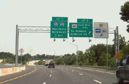
This 2003 photo shows the eastbound John Hanson Highway (US 50) at EXIT 5 (MD 410 / East-West Highway) in Hyattsville. US 50 picks up the unsigned I-595 designation one mile ahead at the Capital Beltway (I-95 and I-495). (Photo by Alex Nitzman, www.aaroads.com.) |
||

|
FIRST PLANNED AS A PARKWAY: In 1937, the Maryland State Planning Commission published a report (titled "Regional Planning Part IV; Baltimore-Washington-Annapolis Area, Guiding Principles and Criteria for Future Action for the 2,500 Square Mile Area") recommending construction of a parkway between the nation's capital and the Maryland state capital. The proposed road was to incorporate aspects of modern parkway design that had been developed during the previous decade. |
||
|
In response to safety concerns, as well as the growing need for mobilizing national defense, the Maryland State Roads Commission began to develop its own plans for freeways throughout the state, including a new freeway between Washington and Annapolis. Although the state's plans were given a boost by the passage of the "Maryland Motorway Act of 1941," which stipulated access control for the first time, the "Annapolis-Washington Expressway" did not receive any special wartime funding. |
||
|
The 14 miles of US 50 from EXIT 13 east to EXIT 27 (MD 2 / MD 450) opened to traffic in 1953. The completed freeway connected to the east with a section of four-lane divided highway opened the previous year (and originally designated MD 404) to connect to the Bay Bridge. The divided highway between MD 2 and the Bay Bridge had at-grade intersections and curb cuts for local businesses. The newly completed highway was co-designated US 301 east of Bowie, and co-designated MD 2 for a four-mile stretch over the new Severn River Bridge. |
||
|
Upon completion of the Bowie-to-Annapolis freeway section, construction crews moved to a five-mile, four-lane freeway section that continued west to EXIT 8 (MD 704) in Lanham. This section was completed in 1957. |
||
|
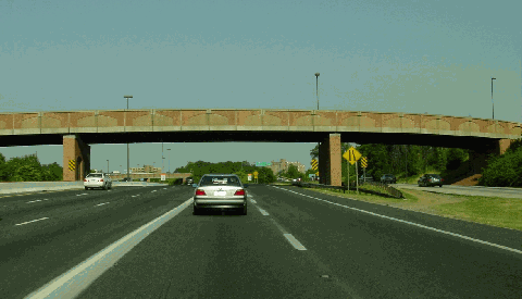
This 2005 photo shows the eastbound John Hanson Highway (US 50 / US 301) at EXIT 22 (MD 665 / Aris T. Allen Boulevard) in Annapolis. (Photo by Jim K. Georges.) |
||

|
GETTING AN INTERSTATE HIGHWAY FOR ANNAPOLIS: By the mid-1970's, it became apparent that the four-lane John Hanson Highway was unable to handle the traffic load between Washington, Annapolis, and the Bay Bridge. The explosive growth of eastern Prince Georges and Anne Arundel counties only made the congestion worse. |
||
|
Maryland officials never had submitted US 50 for Interstate funds because much of the John Hanson Highway was either completed or under construction when the Interstate highway program got underway in 1956. The existing highway was built on a 50-50 (Federal-state) formula common in the pre-Interstate era, but with the cancellation of several projects in the Baltimore and Washington metropolitan areas, state highway officials pushed to get Interstate (90-10, Federal-state) funding to improve US 50. |
||
|
Construction of the 17 miles of freeway that were eligible for Interstate funding took place between 1988 and 1995. By this time, the Interstate designation had changed from I-68 to I-595. (The I-68 designation had moved to the newly completed National Freeway through the Cumberland Gap area of western Maryland.) New signs erected during this period left an empty space for an I-595 shield to be inserted at a future date. |
||

|
During this period, the existing four-lane roadway was rebuilt to accommodate three travel lanes in each direction, with right-of-way reserved in the median for additional lanes as necessary. Original cloverleaf interchanges were rebuilt with flyover ramps at EXIT 7 (I-95 / I-495 / Capital Beltway) and EXIT 13 (US 301 / MD 3 / Crain Highway), while new interchanges were built at EXIT 21 and EXIT 22 for two new freeways (I-97 and MD 665). Design touches such as brick overpasses and dark-colored lightposts and sign gantries improved the appearance of the highway. |
||
|
NEW HOV LANES: Less than a decade after the John Hanson Highway was rebuilt to six lanes, congestion continued to build on the highway through eastern Prince Georges County. To ease this congestion, the Maryland SHA built ten miles of new HOV lanes in the center median from just west of EXIT 6 (Ardwick-Ardmore Road) to just east of EXIT 13 (US 301 / MD 3 / Crain Highway) beginning in 2001. The $19 million "design-build" HOV project, which was completed in November 2002, marked the opening of only the second set of HOV lanes in the state. Unlike most other HOV lanes, the HOV-2 restriction on US 50 / I-595 is in effect 24 hours a day, including on weekends and holidays. |
||

|
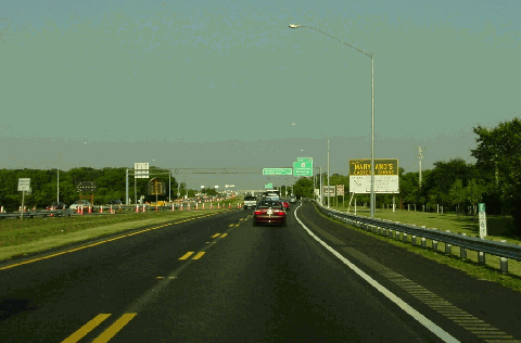
This 2004 photo shows the eastbound John Hanson Highway (US 50 / US 301) approaching EXIT 37 (MD 8) in Stevensville. This is the first eastbound exit on Kent Island after the Chesapeake Bay Bridge. (Photo by Jim K. Georges.) |
||


|
The I-66 designation should be extended east from Washington (through a new K Street Tunnel and New York Avenue Industrial Freeway) along US 50 (John Hanson Highway and Ocean Gateway) to Ocean City. |
||

|
SOURCES: "Baltimore-Washington Parkway: A New Link Is Projected with the Nation's Capital" by Avery McBee, The Baltimore Sun (10/11/1936); "Maryland Lets Road Contract for 6-Mile Annapolis Bypass," The Washington Post (9/17/1949); "DC Freeway: Hanson Highway," The Baltimore Sun (8/12/1954); "John Hanson Highway," The Baltimore Sun (1/15/1957); KCI Technologies; Maryland State Highway Administration; Scott Kozel; Alexander Svirsky. |
||


|
JOHN HANSON HIGHWAY LINKS: |
||
|
JOHN HANSON HIGHWAY CURRENT CONDITIONS: |
||

|
OFF-SITE EXIT LISTINGS: |
||
|
VIEW OR SUBMIT YOUR RATING TO RATETHEROADS.COM: |
||
|
|
||

|
Back to The Roads of Metro Washington-Baltimore home page. |
||
|
Site contents © by Eastern Roads. This is not an official site run by a government agency. Recommendations provided on this site are strictly those of the author and contributors, not of any government or corporate entity. |
||