 |
|
|
|
|
|
|
|
|
|
|
|
|
|
|
|
|
|
|
|
|
|
|
|
|
|
|
|
|
|
|
|
|
|
|
|
|
|
|
|
|
|
|
|
|
|
|
|
|
|
|
|
|
|
|
|
|
|
|
|
|
|
|
|
|
|
|
|
|
|
|
|
|
|
|
|
|
 |
|
|
|
|
 |
|
 |
|
|
|
|
|
|
|
|
|
|
|
|
|
|
|
|
 |
|
|
|
|
|
|
|
|
|
|
|
|
|
|
|
 |
|
|
|
|
|
|
|
|
|
|
|
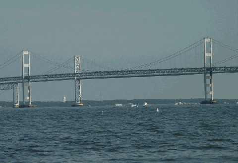
This 2002 photo shows the Chesapeake Bay (William Preston Lane, Jr. Memorial) Bridge from the western (Cape St. Clair) shoreline at Sandy Point State Park. Operated by the Maryland Transportation Authority, the 4.35-mile-long toll bridge carries US 50 and US 301 across the bay. (Photo by Jim K. Georges.)
|
|
|
|
|
|
|
|
|
 |
|
|
|
|
 |
|
|
|
|
|
|
|
|
ORIGINAL (EASTBOUND) BRIDGE
Type of bridge
Construction started
Opened to traffic
Length of main span
Length of side spans
Length, anchorage to anchorage
Total length of bridge and approaches
Width of bridge
Number of traffic lanes
Height of towers above mean high water
Clearance at center above mean high water
Number of cables
Diameter of each of two cables
Cost of original structure
NEW (WESTBOUND) BRIDGE
Type of bridge
Construction started
Opened to traffic
Length of main span
Length of side spans
Length, anchorage to anchorage
Total length of bridge and approaches
Width of bridge
Number of traffic lanes
Height of towers above mean high water
Clearance at center above mean high water
Number of cables
Diameter of each of two cables
Cost of original structure
|
|
|
|
|
|
|
|
|
Suspension
November 1, 1949
July 30, 1952
1,600 feet (487.7 meters)
800 feet (243.8 meters)
3,200 feet (975.4 meters)
22,970 feet (7,001.3 meters)
28 feet (8.5 meters)
2 lanes
354 feet (107.9 meters)
186 feet (56.7 meters)
2 cables
14 inches (35.6 centimeters)
$45,000,000
Suspension
May 19, 1969
June 28, 1973
1,600 feet (487.7 meters)
800 feet (243.8 meters)
3,200 feet (975.4 meters)
22,970 feet (7,001.3 meters)
38 feet (11.6 meters)
3 lanes
379 feet (115.5 meters)
186 feet (56.7 meters)
2 cables
14 inches (35.6 centimeters)
$148,000,000
|
|
|
|
|
|
|
|
|
|
|
|
|
|
 |
|
|
|
|
|
|
|
|
Passenger car cash toll
Passenger car EZ-Pass toll:
|
|
|
|
|
|
|
|
|
$4.00 (eastbound only)
$2.50 (MD EZ-Pass only); $4.00 (non-MD)
(eastbound only)
|
|
|
|
|
|
|
|
|
|
|
|
|
|
|
|
|
|
|
|
|
EARLY PLANS TO CROSS THE BAY: In 1908, a group of private investors led by the Merchants and Manufacturers Association, the predecessor to the Baltimore Chamber of Commerce, advocated the first plans for a bridge crossing Chesapeake Bay. The proposed bridge was to carry interurban trolley lines across the bay from just north of Baltimore to the Eastern Shore community of Tolchester. Local newspapers in Baltimore dismissed the group of investors, which appropriated $1,000 for an engineering survey, for advancing what they called a "ridiculous" proposal.
Although plans for a bridge had to wait, another private group began a ferry service between Annapolis and St. Michael's (Claiborne) in 1919. As demand increased, the ferry service was expanded from two round-trips per day to several per day depending on the weather, and additional ferryboats were added to the line. In 1930, the eastern terminal of the ferry was moved from St. Michael's to Matapeake, near the eastern approach to the current span. This reduced the over-water journey from 23 miles to 8.7 miles. The trip was reduced further in 1943, when the State Roads Commission took over the ferry and moved the western terminal to Sandy Point, near the western approach of the current span.
THE STATE TAKES OVER PLANS: At the beginning of the 1930's, the state organized a Chesapeake Bay Bridge Commission to consider public construction of a bridge financed by municipal bonds, and to be paid for by tolls. In 1931, the commission selected the following two routes for the proposed bridge:
MILLERS ISLAND-TOLCHESTER BRIDGE: This location already was selected by the Chesapeake Bay Bridge Company several years earlier. Most of the water on the proposed route was shallow, and foundation conditions were found to be satisfactory. Traffic studies conducted by the private company found that there would be enough traffic (and tolls) to support construction and operations on the bridge, though no definite data were provided. At the time of the study, private financiers were unwilling to underwrite the project, but the state appeared willing to help expedite studies and construction when conditions improved.
SANDY POINT-KENT ISLAND BRIDGE: The report stated this route - which was the route ultimately chosen two decades later - was the more desirable route "if the needs of the state as a whole" were considered. At approximately 4.3 miles from shore to shore, it was the shortest over-water route in the upper Chesapeake Bay. The Sandy Point-Kent Island route also provided a more direct route to Baltimore, Washington, and points beyond from the Eastern Shore. However, concerns were raised about the route (approximately two miles of the route were over deep water), the engineering challenge of a long-span suspension bridge with anchorages far from the shoreline, and the need for a high clearance over the main shipping channel. A tunnel also was proposed as an alternative for the Sandy Point-Kent Island location, but construction of the tunnel posed engineering challenges of its own.
|
|
|
|
|
|
|
|
|
|
|
|
|
|
|
|
|
Costs of the proposed crossing ranged from $11 million for a two-lane bridge to $16 million for a two-lane tunnel. However, as even state finances were stressed during the Great Depression, the state did not move on the proposal.
In 1937, the Maryland State Legislature authorized the State Roads Commission to create a comprehensive plan for building bridges and tunnels, and to issue revenue bonds to finance such projects. The state used this authority to build the Thomas J. Hatem Memorial Bridge (US 40) over the Susquehanna River and the Harry W. Nice Memorial Bridge (US 301) over the Potomac River, both of which were built during the late 1930's. It also authorized studies for the Millers Island-Tolchester and Sandy Point-Kent Island crossings.
|
|
|
|
|
|
|
|
|
|
|
|
|
|
|
|
|
|
|
|
|
The following year, the State Roads Commission determined that the best site for a Chesapeake Bay bridge was between Sandy Point and Kent Island because it provided better service from the Eastern Shore to the Annapolis-Baltimore-Washington "triangle" than the Millers Island-Tolchester crossing, which provided optimal service to Baltimore but inadequate service to Annapolis and Washington. Although the state authorized toll revenues to be used for the Bay Bridge in the 1938 "Primary Bridge Program" (as it did for the Hatem / US 40 and Nice / US 301 bridges), the onset of World War II pre-empted design and construction.
|
|
|
|
|
|
|
|
|
|
|
|
|
|
|
 |
|
|
|
|
|
|
|
|
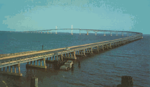
This postcard from the 1960s shows the Chesapeake Bay Bridge (US 50 and US 301) from the Sandy Point shoreline looking east. Construction of the parallel span did not begin until 1969.
|
|
|
|
|
|
|
|
|
|
|
|
|
|
|
|
|
|
THE BAY BRIDGE FINALLY IS APPROVED: Even with the onset of World War II, the State Roads Commission prepared for the day when the Chesapeake Bay ferry would be replaced by a bridge. In 1941, the State Roads Commission took over the property and operation of the ferry, and two years later, moved the western terminus of the ferry from downtown Annapolis to Sandy Point, near the current location of the bridge.
In 1947, the Maryland State Legislature approved construction of the Chesapeake Bay Bridge between Sandy Point and Kent Island. The legislation, which Governor William Preston Lane (in whose honor the bridge was named in 1967) signed into law shortly thereafter, directed the State Roads Commission to build the toll-supported bridge. The state commissioned the engineering firm J.E. Greiner and Company to oversee design and construction of the 4.35-mile-long span.
In anticipation of the bridge, which had been designated MD 404 during the design stage, US 50 was extended east from its old terminus in Annapolis to Ocean City. Prior to the opening of the Bay Bridge, US 50 traffic used the Chesapeake Bay ferry.
BUILDING THE ORIGINAL BAY BRIDGE: Construction contracts for the span were handed out in July 1948. Clearing for the approaches began in January 1949, and ten months later, work began on the massive concrete piers that support the suspension bridge towers and the piers that support the smaller cantilever bridge. By the end of 1950, work crews finished construction of the concrete piers, the two 354-foot main towers, and the concrete anchorages that support the two main cables.
Spinning of the two 14-inch-diameter main cables began in early 1951. These cables were to support a through-truss deck and a 28-foot-wide roadway 1,600 feet between the main towers, and 186 feet above the main navigation channel of Chesapeake Bay. The two 800-foot-long side spans flanked the main span.
The roadway sections of the main suspension span were hoisted into place during late 1951 and early 1952. To provide additional bracing against the frequent high winds on the bay, stiffening through trusses were placed above the roadway.
As work continued on the main suspension span, construction began on the other spans connecting to the main suspension bridge. To the west of the suspension span, there were 13 deck truss spans each measuring between 300 and 500 feet in length. To the east of the suspension span, there was an equal number of flanking deck truss spans, along with a through cantilever bridge that had a main span of 690 feet and a vertical clearance of 58 feet over a secondary navigation channel. Including the main suspension span, the secondary cantilever span, the deck truss spans, and the numerous simple-girder spans, there were a total of 123 spans on the Chesapeake Bay Bridge.
|
|
|
|
|
|
|
|
|
|
|
|
|
|
|
 |
|
|
|
|
|
|
|
|
This 2001 photo shows the two spans of the Chesapeake Bay Bridge taken from the eastbound span during the annual "Bridge Walk." After years of being held in May, the annual event now is a 10-kilometer "Across the Bay" race held in the fall. (Photo by Nick Klissas.)
|
|
|
|
|
|
|
|
|
 |
|
|
|
|
|
|
|
|
|
|
|
|
|
|
|
|
|
|
CONNECTING THE EASTERN AND WESTERN SHORES: The $45 million Chesapeake Bay Bridge opened to traffic on July 30, 1952. Part of the newly extended US 50, the new two-lane span carried approximately 1.2 million vehicles during its first year of service. During the next decade, annual traffic volumes doubled, straining the capacity of the two-lane span (particularly during peak summer weekends) and prompting discussion of a second cross-bay span. For a short time, the success of the span prompted discussion of a new toll road (called the "Maryland Expressway") that was to bypass the existing US 301 north to Delaware, but plans for the expressway were dropped after it was not included in the Interstate highway network.
In 1964, the State Roads Commission retained the services of J.E. Greiner and Company to study a second crossing of Chesapeake Bay. The study evaluated the following locations.
MILLERS ISLAND-TOLCHESTER BRIDGE: The northerly alternative had been selected during the 1920's and 1930's. The 1964 study proposed a 6.9-mile-long, two-lane bridge, and included proposed freeway connections to the Southeast Freeway (MD 702) to the west, and a new route linking MD 213 and US 301 to the east. Although not selected for the second bridge site, a separate 1970 engineering study was conducted for this location.
SANDY POINT-KENT ISLAND BRIDGE: The central alternative proposed a three-lane span parallel to the existing two-lane bridge.
COVE POINT-TAYLORS ISLAND BRIDGE: This newly introduced southerly alternative proposed a 6.3-mile-long, two-lane bridge connecting MD 2-MD 4 in Lusby, Calvert County (near Calvert Cliffs State Park) with MD 16 in Taylor's Island, Dorchester County. No freeways were known to have been considered for this proposal.
In 1967, the Maryland General Assembly authorized the State Roads Commission to oversee construction of up to three additional crossings of Chesapeake Bay. On June 28, 1967, the state recommended that priority be given to a new bridge parallel to the existing crossing, leading some to call the bridge "Agnew's Double-Cross" after the then-current governor, Spiro Agnew.
On May 28, 1968, the Army Corps of Engineers granted a construction permit to build the parallel span 450 feet north of the existing bridge. Construction of the second bridge began on May 19, 1969. Once again, J.E. Greiner and Company oversaw design and construction of the project.
A DIFFERENT BRIDGE: Like the original bridge, the new bridge also featured a suspension bridge with a 1,600-foot-long main span. However, the stiffening trusses on the new bridge were beneath the roadway, providing motorists an unblocked view of Chesapeake Bay. The towers also were different: at a height of 379 feet, they stood 25 feet taller than their predecessor, and horizontal bracings gave the new towers a more streamlined look than the towers on the older bridge. Two 14-inch cables support the main suspension span 186 feet above the bay.
The design for the secondary bay channel was a steel arch span, which differed from the cantilever design on the older bridge. Like the old cantilever bridge, the new steel arch bridge had a main span of 690 feet and a vertical clearance of 58 feet.
The 4.35-mile-long new bridge featured 124 separate spans. However, the new bridge had only three deck truss spans on either side of the main suspension bridge, not the 13 on each side found on the old bridge. (These were replaced by high-level girder spans on the new bridge.)
The new bridge featured a 38-foot-wide deck to accommodate three westbound lanes. During peak travel periods, the left lane on the new bridge was reversible, permitting overflow traffic from the older eastbound span. Contraflow travel is governed by overhead traffic signals.
The $148 million parallel span opened to traffic on June 28, 1973. Upon opening, the existing two-lane bridge was restriped to allow two lanes of eastbound traffic. In 1997, the MdTA prohibited passing along the entire length of both spans because of a mix of congestion and a long accident history.
|
|
|
|
|
|
|
|
|
|
|
|
|
|
 |
|
 |
|
|
|
|
|
|
|
|
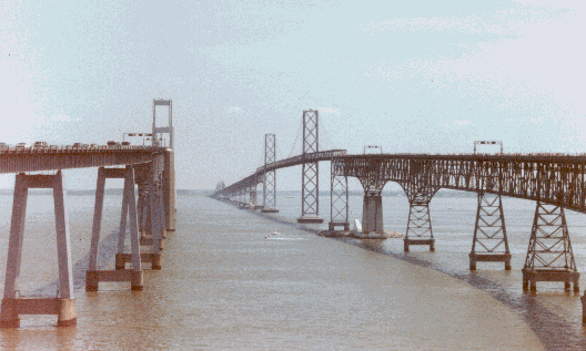
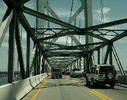
LEFT: This 1976 photo shows the westbound Chesapeake Bay Bridge approaching the main suspension span. (Photo by Scott Kozel, from the "Roads to the Future" site). RIGHT: This 2002 photo shows the eastbound Chesapeake Bay Bridge approaching the eastern tower of the suspension span. (Photo by Jim K. Georges.)
|
|
|
|
|
|
|
|
|
|
|
|
|
|
|
|
|
|
MAINTAINING THE BAY BRIDGE: Between 1986 and 1988, the 35-year-old eastbound Bay Bridge was completely redecked, forcing the closure of the older span during the winter months. Traffic was rerouted onto the newer westbound span during the reconstruction of the eastbound bridge.
As the westbound bridge ended its third decade of service, the Maryland Transportation Authority (MdTA) inspected the deck for potential problems in 1999. The MdTA recommended complete redecking of 21 spans and resurfacing on 95 other spans, on which work ("phase 1") began in early 2002. By the end of 2003, cracks began appearing on the underside of the concrete deck. In early 2004, the cracking problem had become more serious after investigators found the new overlay already had separated from the original concrete, which had been laid down more than 30 years earlier. The cracking was blamed on everything from the thin deck of the westbound span to inadequate surface preparation, and from the use of two incompatible epoxies to the cold temperatures in which the work was performed. However, the westbound deck clearly was showing its age.
In a February 2005 statement, MdTA Chairman Robert Flanagan said additional deck sections along the westbound span are likely to be replaced following the recommendations of an independent overview board. The MdTA, which also implemented stricter oversight of consultants, contractors, and suppliers, expects the board's oversight measures to be carried into the deck replacement project on the main suspension span ("phase 2").
Work began to replace the westbound deck in December 2006. To expedite construction, all work is being done in the off-peak winter months, making it easier for construction crews to divert traffic onto the eastbound span (which is being pressed into use for two-way traffic). The 300 roadway panels for the redecking project - 144 for the suspension span and 156 for the through truss span - are being fabricated off-site by American Bridge Company at its Sparrows Point facility and shipped by barge 20 miles south to the construction site. Each roadway panel measures between 15 and 49 feet long, and has new safety railing and wiring. The westbound deck replacement project is scheduled for completion in 2010.
The MdTA plans another redecking of the eastbound span in 2018 as that bridge's deck nears the end of its 30-year life. After an August 2008 accident in which a tractor-trailer swerved off the bridge into Chesapeake Bay, investigators revealed damaged and deteriorated parapets beyond those hit upon the truck's impact. Engineers devised a temporary solution of reinforcing the existing U-bolt connection between the concrete deck with a connection plate, but a more permanent solution may need to wait until next decade.
IS ANOTHER BAY BRIDGE NEEDED? According to the MdTA, the Bay Bridge carries approximately 65,000 vehicles per day (AADT) on the average weekday. However, the bridge carries as many as 95,000 vehicles per day on summer weekends. To ease eastbound congestion on US 50-US 301 leading to the bridge, the MdTA opened an extended, half-mile-long "EZ-Pass only" lane at the Sandy Point toll plaza in 2005.
In 2004, the MdTA studied current and future traffic patterns on the existing Bay Bridge. The agency arrived at the following conclusions:
On most weekdays, about 70% of eastbound traffic comes from the Baltimore area, with the remainder coming from the Washington area. The split is 50-50 on summer weekends.
Most westbound traffic (about 60%) is generated from Kent County, Queen Anne's County, and Delaware. A considerable portion of this traffic is generated from the US 301 bypass of I-95 between Delaware and Virginia. On summer weekends, about two-thirds of westbound traffic is generated from Ocean City, Rehoboth Beach, and other southern Eastern Shore counties.
By 2018, the eastbound Bay Bridge will need to be redecked (it was redecked previously in 1988). This may require a partial or complete closure of the span, and create substantial travel delays.
By 2025, the MdTA expects the bridge to carry 85,000 vehicles per day on weekdays, and as many as 135,000 vehicles per day on summer weekends. The bridge would be at the worst level of service (receiving a grade of "F") for as many as 12 hours per day by 2025. Furthermore, the bridge already suffers from a higher-than-average accident rate (mostly from rear-end collisions), a condition that is expected to worsen with more congested conditions.
It is too early to say if a new fixed crossing - either at the current site or further north at the Millers Island-Tolchester site - is needed over Chesapeake Bay, but this topic is likely to be the subject of future studies.
|
|
|
|
|
|
|
|
|
|
|
|
|
|
|
 |
|
|
|
|
|
|
|
|
This photo shows the Chesapeake Bay Bridge (US 50-US 301) from high above Chesapeake Bay. (Photo by Maryland Transportation Authority, www.mdta.state.md.us.)
|
|
|
|
|
|
|
|
|
|
|
|
|
|
 |
|
 |
|
|
|
|
|
Lights should be installed along the length of the Chesapeake Bay Bridge.
|
|
|
|
|
|
|
|
|
|
|
|
|
 |
|
|
|
|
|
The Chesapeake Bay Bridge should become part of an extended I-66 that would continue east from the Washington metropolitan area to Ocean City.
|
|
|
|
|
|
|
|
|
|
|
|
|
|
|
|
|
|
|
|
|
|
|
|
|
|
 |
|
|
|
 |
|
|
|
|
|
SOURCES: Report of the Chesapeake Bay Bridge Commission, Chesapeake Bay Bridge Commission (1931); "A Comprehensive Bridge-Highway Plan for Maryland," The Baltimore Sun (5/26/1938); "Maryland's New Bridge Program" by C.M. Falconer, The Baltimore Sun (8/10/1938); The Chesapeake Bay Bridge Engineering Report, Maryland State Roads Commission (1948); Report on Traffic and Revenues, Proposed Chesapeake Bay Bridge, Coverdale and Colpitts (1948); Location Studies: Chesapeake Bay Crossings, Maryland State Roads Commission (1964); Great American Bridges and Dams by Donald C. Jackson, Preservation Press-John Wiley and Sons (1988); "Bob Miller's Bridge" by Dan Rodrick, The Baltimore Sun (7/28/2002); "Spanning Half a Century" by Darragh Johnson and Nelson Hernandez, The Washington Post (7/30/2002); "Maryland Plans Expansion of Chesapeake Bay Bridge" by Peter Samuel, Toll Roads News (12/29/2004); "Bay Bridge Deck Investigation," Maryland Transportation Authority (2005); "Span Awaits Assembly" by Michael Dresser, The Baltimore Sun (9/06/2007); "Emergency Repairs for Bay Bridge Following Fatal August 10 Crash" by Bruce Buckley, Engineering News-Record (8/30/2008); Robert V. Droz; Nick Klissas; Scott Kozel.
US 50, US 301, and I-66 shields by Scott Colbert.
Lightpost by Millerbernd Manufacturing Company.
|
|
|
|
|
|
|
|
|
|
|
|
|
|
|
|
 |
|
 |
|
|
|
|
|
|
|
|
|
|
|
|
|
|
|
CHESAPEAKE BAY (WILLIAM PRESTON LANE, JR. MEMORIAL) BRIDGE CURRENT TRAFFIC CONDITIONS:
|
|
|
|
|
|
|
|
|
|
|
|
 |
|
|
|
|
|
|
|
|
|
 |
|
|
|
|
|
|
|
|
 |
|
|
|
|
|
|
|
|
|
|
|
|
Site contents © by Eastern Roads. This is not an official site run by a government agency. Recommendations provided on this site are strictly those of the author and contributors, not of any government or corporate entity.
|
|
|
|
|
|
|
|
|
|