
|
|
||
|
This 2004 photo shows the Whitehurst Freeway (US 29) looking east from atop the Key Bridge. (Photo by Laura Siggia Anderson.) |
||
|
Length: |
||
|
0.8 mile (1.3 kilometers) |
||

|
THE K STREET SKYWAY: Planning began in 1942 for the "K Street Skyway," a four-lane elevated highway stretching approximately nine blocks from 27th Street NW and the Rock Creek and Potomac Parkway west to M Street and the Key Bridge. The skyway above K Street, which connects downtown with Canal Road and the Key Bridge, was designed to bypass M Street, the main thoroughfare through Georgetown. At the time, M Street was a cobblestone street through an industrial waterfront neighborhood, not the upscale shopping destination that it is today. |
||
|
H.C. Whitehurst, who was director of the District Highway Department, conceived the skyway that eventually bore his name. He designed the K Street Skyway as the first piece of a long-range, district-wide plan to build freeways through Washington and its neighboring suburbs. Whitehurst, who was an early booster of the Interstate highway system as chairman of the American Road and Transportation Builders Association (ARTBA), died while the freeway was under construction. The Whitehurst Freeway was named for the former highway chief after his death. |
||
|
At the western terminus, a ramp was built to connect the northbound Key Bridge to the eastbound freeway, providing direct access for northbound US 29 traffic. The original design of the freeway also had a loop ramp connecting westbound freeway traffic directly onto the bridge. All other traffic from the freeway emptied out at the "T"-interchange on M Street. |
||
|
Work began on July 7, 1947 on the construction of the freeway. During the summer and fall of 1947, workers laid the foundations for the steel supports that were the lift the freeway above K Street. However, sporadic steel shortages - the result of postwar demands on the construction industry - resulted in delays in building the steel viaduct. Nevertheless, much of the steelwork on the viaduct was completed by the fall of 1948 except at the eastern and western termini where work still was in its early stages. |
||

|
This 1948 map from the September 19, 1948 edition of The Washington Post shows the route of the Whitehurst Freeway (US 29) then under construction along with the proposed easterly extension along K Street to Florida Avenue. |
||

|
This 1947 photo shows initial construction of the Whitehurst Freeway (US 29) looking west toward the M Street terminus in Georgetown. The Washington approach to the Key Bridge was rebuilt as part of the project. (Photo from the District of Columbia Department of Transportation archives.) |
||

|
This 1949 photo shows the Whitehurst Freeway (US 29) nearing completion at the Key Bridge. (Photo from the District of Columbia Department of Transportation archives.) |
||
|
ONCE CONSIDERED AS AN INTERSTATE: Planning for a northwest extension of the Whitehurst Freeway into Maryland began in 1950, one year after the original stretch of freeway opened. In 1956, the Whitehurst Freeway was added to the Interstate highway system, making it eligible for 90 percent Federal funding for improvements. On the drawing board for the Whitehurst Freeway was an expansion to six or eight lanes along the existing right-of-way. A 1957 planning study by the National Capital Planning Commission (NCPC) called for an eight-lane Potomac River Freeway from the Inner Loop (today's interchange between the Whitehurst Freeway, I-66, and K Street) northwest to the Capital Beltway (I-495). Upon completion, the Whitehurst Freeway was to be re-christened as the Potomac River Freeway. |
||
|
The Potomac River Freeway corridor was one of two corridors considered for the extension of I-70S (today's I-270) into the District of Columbia; the other corridor, which was to be called the Northwest Freeway, was to be routed roughly along Wisconsin Avenue. Strident opposition in Northwest Washington to the proposed I-70S prompted Congress to impose a five-year moratorium on building new freeways west of 12th Street. Eventually, the Northwest routes for I-70S - and later the I-70S North Central extension altogether - were dropped. |
||

|
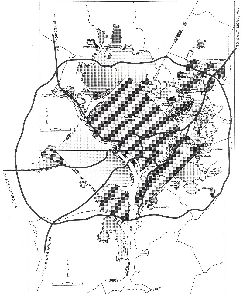
In 1961, the NCPC considered the Whitehurst-Potomac River Freeway as a connector between downtown Washington and a new Potomac River crossing. The NCPC studied three alternatives, including a new bridge south of the existing Key Bridge and a site near Georgetown Reservoir, but decided upon a site between Glvoer-Archbold Park on the District side and the Spout Run Parkway on the Virginia side - over the Three Sisters Islands, a series of rock formations in the middle of the Potomac River - for the new crossing. The proposed $28.5 million bridge-and-highway combination was planned as a truck route to Virginia, as trucks were prohibited from the Theodore Roosevelt Bridge (I-66) then under construction (at the urging of the NCPC and the National Park Service). |
||
|
The I-266 designation for this plan first appeared in a 1964 study for the proposed Potomac River Freeway and the Three Sisters Bridge. Under the I-266 proposal, the existing Whitehurst Freeway was to serve as the four-lane outbound roadway for the new Potomac River Freeway. A new parallel four-lane elevated roadway was to be built south of the existing freeway to carry inbound traffic. West of the existing end of the Whitehurst Freeway, the eight-lane I-266 was to be extended west on new alignment between the C&O Canal and the Potomac River. An interchange was to be built for the proposed Glover-Archbold Parkway (which was to be built through the eponymously named park) and Palisades Parkway (which was to continue along the Potomac shoreline into Maryland to I-495). At this point, I-266 was to cross the Potomac and the Three Sisters islands into the Virginia, where it was to be built over the Spout Run Parkway en route to the proposed I-66 in Arlington. |
||

|
By the end of 1964, workers completed a six-block-long viaduct south at the eastern end of the Whitehurst Freeway that was to become part of the new Potomac River Freeway. The viaduct, which was to carry four additional lanes of traffic, also had ramps to I-66 and the North Leg of the Inner Loop (which never was built). Further west, the District government condemned two historic warehouses along the right-of-way for the expanded freeway. However, I-266 appeared to be an on-again, off-again project through much of the 1960's as its funding remained uncertain. |
||

|
This 2002 photo shows the Whitehurst Freeway (US 29) looking west at 34th Street, NW. Note how the ramp from the Key Bridge is architecturally consistent with the main span. (Photo by NARPAC, Inc.) |
||
|
AT LONG LAST, REHABILITATION: By the early 1980s, the Whitehurst Freeway had shown signs of age and neglect. Throughout the 1960s and early 1970s, it appeared that rehabilitation of the Whitehurst would come with an expanded Potomac River Freeway. Although I-266 had been killed off, funding to repair the Whitehurst was hard to come by. Some planners and officials began to consider replacing the elevated freeway with an expanded six-lane K Street boulevard - as was being done for New York's West Side Highway - under the premise that an at-grade urban arterial would reconnect Georgetown to the Potomac shoreline. |
||
|
Other planners suggested tearing down the existing elevated roadway and tunneling underneath K Street for a new Whitehurst Freeway. The idea for a Whitehurst tunnel was not a new idea: the Georgetown Planning Council first suggested it in 1965 as a four-tube, eight-lane tunnel underneath the Potomac shoreline, and Federal highway officials considered it in 1968 as part of a Three Sisters Tunnel alternative. However, District officials shelved the tunnel proposal because of its prohibitive cost, which was estimated at $400 million by the early 1980's. |
||

|
This 2004 photo shows the Whitehurst Freeway (US 29) heading west toward the Key Bridge. (Photo by Jim K. Georges.) |
||
|
WHITEHURST REMOVAL GAINS TRACTION: Responding to consistent pressure from a small - but vocal - contingent of Georgetown residents and businesses, the District of Columbia Department of Transportation (DDOT) unveiled plans to tear down the Whitehurst Freeway in March 2005. District officials offered 17 different alternatives, six of which involved keeping the existing freeway in place. |
||
|
Once again, demolition proponents blame the Whitehurst as an impediment to connecting Georgetown with the waterfront, particularly as construction on the long-delayed Georgetown Waterfront Park began in June 2006. Those opposed to demolition cite studies that the approximately 50,000 vehicles using the Whitehurst each day would clog already overburdened K and M streets in the absence of a freeway. They also cite possible delays in emergency response time if the freeway were to be dismantled. |
||

|
SAVE THE WHITEHURST: The Whitehurst Freeway should be preserved as an invaluable transportation asset. To increase the freeway's usefulness, new ramps should be built to connect the eastbound lanes of the freeway to the northbound and southbound Rock Creek and Potomac Parkway, as shown in "Alternative 4" of DDOT's 2005 Whitehurst Freeway study. |
||

|
SOURCES: "Revised Road Program for DC Approved," The Washington Post (1/25/1942); "$3,300,000 Whitehurst Freeway Work 70 Percent Complete," The Washington Post (9/19/1948); "Whitehurst Freeway Traffic Plans Released," The Washington Post (10/07/1949); "Road, Bridge Work Gets $65 Million" by John J. Lindsay, The Washington Post (8/10/1958); "New Bridge Slated for Early Start" by Willard Clopton, The Washington Post (8/06/1961); "Opening of Third Ramp, Due in Month, Should Simplify Whitehurst Detours," The Washington Post (11/02/1964); "Location Studies, Interstate Route 266," National Capital Planning Commission (1964); "Interstate 266 Route Is Fixed, Now for a Potomac Bridge" by George Lardner, Jr., The Washington Post (3/26/1965); "A Return to Historic Georgetown," The Washington Post (10/14/1965); "New City Road Map Would Scrap Freeway Link, Tunnel Potomac" by Jack Eisen, The Washington Post (11/05/1968); "House Clears Path To Build Three Sisters" by Stephen Green, The Washington Post (10/06/1972); "DC Razes Two Historic Buildings" by Timothy S. Robinson, The Washington Post (3/01/1973); "I-66 Corridor Transportation Alternatives Study: Draft Environmental/Section 4(f) Statement," U.S. Department of Transportation (1973); "Three Sisters Highway Project Is Killed Again" by Douglas B. Feaver, The Washington Post (5/13/1977); "Whitehurst Freeway: Replace, Repair, Remove?" by Stephen J. Lynton, The Washington Post (3/14/1984); "Remnant of Interstate Going Away" by Barbara Gamarekian, The New York Times (7/28/1985); "Whitehurst's Makeover Nears Reality" by Stephen C. Fehr, The Washington Post (3/09/1989); "Panel Approves DC Plan To Fix Whitehurst Freeway" by Stephen C. Fehr, The Washington Post (1/05/1990); "Whitehurst Switch a Shocker to Many" by Stephen C. Fehr, The Washington Post (12/11/1990); "Boulevard Backers Back" by Stephen C. Fehr, The Washington Post (9/09/1991); "DC Road Work Is Detoured by Red Tape" by Alice Reid, The Washington Post (3/19/1996); "Two DC Road Repairs Mean Slow Traffic," The Washington Post (7/28/1996); "Treasures of the Whitehurst Freeway: Archaeologists Find Historical Trove in Excavation for Exit Ramp on Rock Creek" by Linda Wheeler, The Washington Post (2/14/1997); "Concern About Support Closes Whitehurst Freeway" by Alice Reid, The Washington Post (4/19/1997); "The Final Touches on the Whitehurst Freeway," The Washington Post (8/20/1988); "As Depression Deepens, ARTBA Defends Road Program, User Taxes" by Tom Kuennen, Expressways Online (April 2001); "Whitehurst Freeway Eyed for Demolition," The Associated Press (5/02/2005); "District Trying To Topple the Whitehurst" by Steven Ginsberg, The Washington Post (5/08/2005); "Whitehurst Freeway Deconstruction Feasibility Study," District of Columbia Department of Transportation (2005); NARPAC, Inc.; National Society of Black Engineers; Mike Hale; Scott Kozel. |
||

|
WHITEHURST FREEWAY LINKS: |
||
|
WHITEHURST FREEWAY CURRENT TRAFFIC CONDITIONS: |
||
|
WHITEHURST FREEWAY VIDEO LINKS: |
||

|
THE EXITS OF METRO WASHINGTON-BALTIMORE: |
||

|
Three Sisters Bridge (I-266, unbuilt) |
||

|
Back to The Roads of Metro Washington-Baltimore home page. |
||
|
Site contents © by Eastern Roads. This is not an official site run by a government agency. Recommendations provided on this site are strictly those of the author and contributors, not of any government or corporate entity. |
||