
|
|
||
|
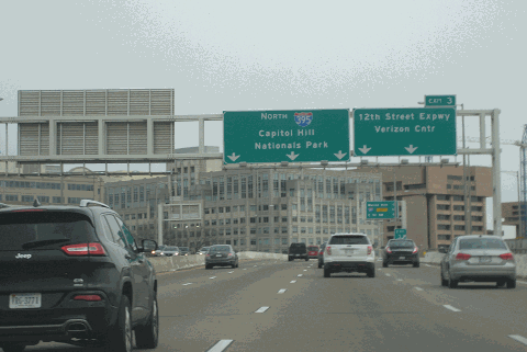
This 2016 photo shows the northbound Southwest Freeway (I-395) approaching EXIT 3 (12th Street Expressway). (Photo by Steve Anderson.) |
||
|
Length: |
||
|
1.6 miles (2.6 kilometers) |
||
|
THE FIRST LINK OF THE INNER LOOP: Planned by District officials as early as 1946, the Southwest Freeway was first publicized in a 1951 presentation by city traffic director George Keneipp before the Civitan Club at the Mayflower Hotel. The proposed freeway, which was to extend from the 14th Street Bridge to South Capitol Street, was conceived as part of a $200 million general construction program. It also was incorporated into plans to redevelop Southwest Washington, which at the time was a lower-class (but commercially thriving) neighborhood. |
||
|
When it was first planned, the 3.4-mile-long Southwest Freeway was to have six lanes throughout its entire length. It was to extend east from the concurrently proposed bridge over Washington Channel over F Street SW. A pair of 33-foot-wide roadways was to have been separated by a four-foot-wide median barrier and flanked by 60-foot-wide sloped embankments. |
||
|
The Southwest Freeway received a boost when a 1955 report by De Leuw, Cather and Company proposed the link as part of the $272 million, 18-mile Inner Loop project in a 1955 report. The report advocated keeping the Southwest Freeway route approved earlier that decade, but instead recommended expanding the freeway to eight lanes (except in the area of the Maine Avenue interchange, where there were to be three through lanes in each direction). The cost of the freeway was estimated at $34 million, or roughly $10 million per mile. |
||
|
DESIGN OF THE SOUTHWEST FREEWAY: The configurations on the Southwest Freeway were as follows: |
||
|
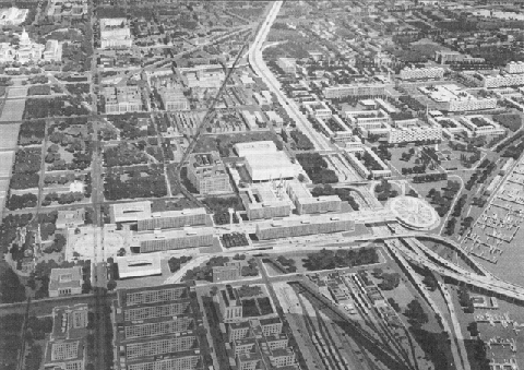
This 1961 artist's depiction shows the Southwest Freeway (I-395) looking east. The Southwest Freeway, which was completed two years later, is shown entering from Washington Channel on the lower right corner. Note the Maine Avenue ramps (on the Washington Channel shoreline) that were to be used for the unbuilt South Leg Freeway (I-695). (Photo courtesy of Gelman Library, Peter S. Craig papers, George Washington University; supplied by Douglas A. Willinger.) |
||

|
WITH THE HELP OF INTERSTATE FUNDING, CONSTRUCTION PROGRESSES
District officials pushed successfully to have the Southwest Freeway, along with the rest of the Inner Loop, as part of the Interstate highway system signed into law by President Eisenhower in 1956. The law provided for 90 percent financing for the freeway, with the remainder coming from District funds. |
||
|
Construction under the first contract began at 4th Street SW in December 1957. Work under a second contract from 4 Street east to the "Center Leg" interchange began in January 1958, while construction of the remainder of the route - including the Washington Channel Bridge - got underway in March 1959. In 1960, District officials requested a shift in funding from other parts of the Inner Loop toward completion of the Southwest Freeway. Under the revised schedule, work was accelerated on the section between the 14 Street Bridge and 9th Street SW. This section was opened to traffic on July 31, 1962. |
||
|
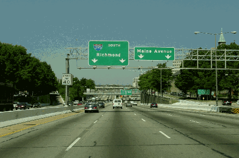
This 2000 photo shows the southbound Southwest Freeway (I-395) approaching EXIT 4 (Maine Avenue). (Photo by Jim K. Georges.) |
||


|
I-95 BECOMES I-395: When it opened, the Southwest Freeway was part of Interstate 95. The original plans for I-95 through the District called for I-95 to continue onto the Center Leg Freeway, parts of the North Leg and North Central freeways, and the Northeast Freeway before entering Maryland. After more than 15 years of controversy, District officials moved to cancel a number of freeways, including roads that were to carry the I-95 designation, between 1973 and 1976. More than $2 billion in highway funds originally set aside for these highways were reallocated for the construction of the Metro system. |
||
|
The cancellations of the North Leg, North Central, and Northeast freeways dead-ended I-95 at the north end of the Center Leg Freeway, prompting District officials - in cooperation with Virginia and Maryland officials - to reroute I-95 around the eastern half of the Capital Beltway. In 1977, District and Virginia officials re-designated the orphaned section of I-95 as Interstate 395, a move that was approved immediately by the American Association of State Highway and Transportation Officials (AASHTO). |
||
|
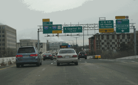
This 2016 photo shows the northbound Southwest Freeway (I-395) at the split for the Center Leg Freeway (I-395), which splits to the right, and the Southeast Freeway (I-695), which splits to the left from EXIT 5 on I-395. (Photo by Steve Anderson.) |
||

|
SOURCES: The Comprehensive Plan for the National Capital and Its Environs, National Capital Park and Planning Commission (1950); "Highway Planners Propose New Way into Southwest," The Washington Post (9/16/1952); "Bridge-Highway Plan Sound for District, Expert Reports" by Sam Zagoria, The Washington Post (10/27/1952); "$328 Million Roads Plan Is Proposed in DC Area" by Matt McDade, The Washington Post (12/14/1952); "Potomac Span Row Keeps on Rolling" by Sam Zagoria, The Washington Post (3/28/1954); "District Ready To Design Southwest Freeway" by Grace Bassett, The Washington Post (5/16/1954); "DC Seeks Federal Aid on Freeway," The Washington Post (2/25/1955); "50 MPH Traffic Loop Would 'Feed' Central DC" by Robert C. Albrook, The Washington Post (12/04/1955); Inner Loop Freeway System, De Leuw, Cather and Company (1955); "First Expressway Link To Start in Two Years," The Washington Post (8/11/1956); "Southwest Freeway Contract Near," The Washington Post (12/13/1957); "Southwest Freeway To Be Open Year Sooner," The Washington Post (9/16/1960); "Bridge, Expressway Will Open July 31," The Washington Post (7/22/1962); "DC Highway Officials Set To Open New Section of Southwest Freeway," The Washington Post (8/22/1963); "DC Roads Take Turn for the Better; $400 Million in Work Getting Done in City" by Alice Reid, The Washington Post (10/12/1997); "DC, USDOT Sign Agreement With Contractor To Preserve, Enhance City's Major Bridges and Roads," Federal Highway Administration (6/19/2000); "Southeast Freeway Could Go Under: New Six-Lane Boulevard, Tunnel Would Boost Area Development" by Stephen C. Fehr, The Washington Post (10/09/2000); Anacostia Waterfront Corporation; District of Columbia Department of Transportation; Scott Kozel; Scott Oglesby; Alexander Svirsky; Douglas A. Willinger; William F. Yurasko. |
||
|
SOUTHWEST FREEWAY LINKS: |
||
|
SOUTHWEST FREEWAY CURRENT TRAFFIC CONDITIONS: |
||
|
SOUTHWEST FREEWAY VIDEO LINKS: |
||

|
THE EXITS OF METRO WASHINGTON-BALTIMORE: |
||

|
|
||

|
Back to The Roads of Metro Washington-Baltimore home page. |
||
|
Site contents © by Eastern Roads. This is not an official site run by a government agency. Recommendations provided on this site are strictly those of the author and contributors, not of any government or corporate entity. |
||