
|
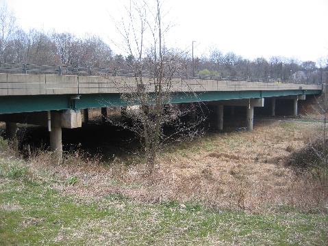
This 2009 photo shows Connecticut Avenue (MD 185) over Matthew Hanson State Park. This overpass crosses the right-of-way for what was to be the Outer Beltway and later the Rockville Facility before it was canceled formally in 1989. Cloverleaf ramps stubs on Connecticut Avenue also reveal plans for the shelved freeway. (Photo by Steve Anderson.) |
||
|
PLANNED AS PART OF THE OUTER BELTWAY: In 1950, officials in Maryland devised plans for a "Cross-County Loop," a controlled-access highway that was to link US 240 (now I-270) in Montgomery County with the Baltimore-Washington Parkway (MD 295) in Prince George's County. It was the direct predecessor to today's Intercounty Connector and a springboard for a more ambitious highway proposal. |
||
|
In 1965, local groups petitioned the Maryland State Roads Commission (SRC) to move the route of the beltway north about five miles such that the Potomac River crossing would be at Block House Point instead of Great Falls. Jerome Wolff, chairman of the SRC, said the state took "a dim view" of changing route plans once they are settled, but Walter Addison, the head of the SRC's planning division, acknowledged the benefits of changing this alignment since the narrowest point between the Capital and Outer beltways (in Rockville) were only two and one-half miles apart, not enough to provide ample freeway spacing. |
||
|
Even with the route of the Outer Beltway in flux, the SRC spent $3 million on rights-of-way along the original alignment throughout the 1960's, and even spent $500,000 to build a six-lane bridge to carry Connecticut Avenue (MD 185) over the proposed beltway in Silver Spring in 1968. An assistant engineer for the SRC said "some road" would go under Connecticut Avenue even if it were not the Outer Beltway. |
||
|
The Rockville Facility was as controversial as the Outer Beltway--later truncated to the Intercounty Connector (MD 200)--proved to be; only two years after the SHA announced route plans, the cost estimate for the Rockville Facility had doubled to $80 million taking into account higher construction and land acquisition costs. Public hearings on the freeway continued for more than a decade, but there was nothing to show for these discussions. |
||
|
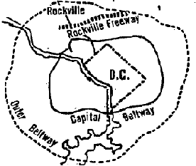
This 1970 map shows the general location of the Rockville Facility (Freeway) in relation to the rerouted Outer Beltway, the northern arc of which eventually was built as I-370 and the Intercounty Connector (MD 200). (Map by Joseph Mastrangelo, The Washington Post.) |
||
|
By the end of the 1980's, it had become clear that the Rockville Facility never would be built to its full extent as the final environmental impact statement rejected the full freeway alternative. In 1988, Montgomery County Executive Sidney Kramer recommended that the Rockville Facility right-of-way between Veirs Mills Road (MD 586) and MD 650 be used for a park; although Kramer believed the freeway would relieve congestion, he argued benefit would be more than offset by community disruption. Conversion of the Rockville Facility right-of-way to parkland was not a new idea; community groups had explored this alternative as early as 1971. |
||
|
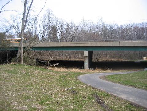
This 2009 photo shows the Connecticut Avenue (MD 185) overpass from another angle. Today a multi-use trail winds through Matthew Hanson State Park along where the six-lane Rockville Facility was to have been built. (Photo by Steve Anderson.) |
||

|
SOURCES: "Parkway Plan Is Stepped Up in Maryland" by Laurence Stern, The Washington Post (1/24/1958); "Buy Now, Officials Urge, For Future Land Routes," The Washington Post (1/29/1958); "New Routes Proposed for Beltway in County," The Washington Post (8/07/1965); "Connecticut Avenue Overpass Started," The Washington Post (7/18/1967); "Outer Belt Shift Given More Study" by Jack Eisen, The Washington Post (10/26/1967); "Planned Maryland Outer Belt Route Will Stand" by Thomas W. Lippman, The Washington Post (1/23/1968); "Rockville Freeway Plans Stir Opposition" by Edward Walsh, The Washington Post (1/28/1972); "Montgomery Council, Senate Delegation Ask Freeway Delay" by Edward Walsh, The Washington Post (2/06/1972); "Rockville Freeway Is Off for Year" by Douglas Watson, The Washington Post (2/15/1972); "Road Builders See No Letup" by Jack Eisen, The Washington Post (6/06/1974); "Public Debates Roads Connecting Montgomery and PG" by Paul Hodge, The Washington Post (10/11/1979); "A $16 Million Road to Nowhere" by Elsa L. Walsh, The Washington Post (12/10/1981); "Debate Surrounds Connector Highway Proposal" by R.H. Melton, The Washington Post (9/29/1983); "Panel Says Area Roads, Bridges Being Ignored" by Stephen J. Lynton, The Washington Post (11/20/1984); "Kramer Urges Making Park of Road Land" by Jo-Ann Armao, The Washington Post (12/13/1988); "City and Town Actions," The Washington Post (10/05/1989); "Montrose Parkway Faces Battle" by Amit R. Paley, The Washington Post (8/19/2004); "Montrose Parkway Is Moving Along," WTOP Radio (5/18/2007); HistoricAerials.com; Maryland State Highway Administration. |
||
|
ROCKVILLE FACILITY LINKS: |
||
|
Back to The Roads of Metro Washington-Baltimore home page. |
||
|
Site contents © by Eastern Roads. This is not an official site run by a government agency. Recommendations provided on this site are strictly those of the author and contributors, not of any government or corporate entity. |
||