
|
This 2004 photo shows the westbound Potomac River Freeway (I-66) approaching the split for the E Street Expressway. Trucks are diverted onto the E Street Expressway because they are not permitted on the Theodore Roosevelt Bridge and I-66 west to the Capital Beltway (I-495) in Virginia. Note the empty sign on the left side of the gantry, which was reserved for the unbuilt South Leg Freeway (I-695). (Photo by Jim K. Georges.) |
||

|
PLANNED AS THE WEST LEG OF THE INNER LOOP: Proposed by District officials as early as 1946, the Potomac River Freeway received a boost when a 1955 report by De Leuw, Cather and Company proposed the link as part of the $272 million, 18-mile Inner Loop project in a 1955 report. The route was dubbed the "West Leg Freeway" in early planning reports because it formed the west leg of the District's proposed inner loop freeway network. District officials pushed successfully to have the Potomac River Freeway, along with the rest of the Inner Loop, as part of the Interstate highway system signed into law by President Eisenhower the following year. The law provided for 90 percent financing for the freeway, with the remainder coming from District funds. |
||
|
As originally planned, the 0.9-mile-long "West Leg" was to connect the proposed Theodore Roosevelt Bridge, which was to bring I-66 from Virginia into the District, with the Whitehurst Freeway and eventually, an extension of I-66 via the North Leg Freeway. To the south, the West Leg was to connect to the South Leg Freeway (I-695), an unbuilt freeway that was to tunnel under West Potomac Park en route to the Southwest Freeway (I-395). In addition to the interchanges with the Theodore Roosevelt Bridge ramps and the Whitehurst Freeway (US 29), there also is an interchange with the E Street Expressway (no route designation), a short stub that was not part of the Inner Loop system. |
||
|
Designed as part of the redevelopment of Foggy Bottom, which at the time was a blue-collar residential and industrial area, the "West Leg" was planned mostly as a depressed eight-lane freeway. More than 800 people in 160 residential units had to be relocated for construction of the "West Leg," and many more people moved out in the ensuing redevelopment as Foggy Bottom was to become more gentrified, as best exemplified by construction of the Watergate waterfront development complex. |
||
|
CONSTRUCTION THROUGH FOGGY BOTTOM: The first construction contracts for the interchange between the Potomac River Freeway, Whitehurst Freeway, Rock Creek and Potomac Parkway, and K Street were awarded in July 1960; construction crews began work here the following spring. The original plan at this location called for a three-level interchange, but the NCPC and Fine Arts Commission spent nearly one year redesigning the interchange so it could be less intrusive. Ramps also were built for an eventual extension of I-66 onto the North Leg Freeway; the ramps were demolished in the late 1990's as part of the Whitehurst Freeway reconstruction. |
||

|
This circa 1963 photo shows construction of the trench that was to carry the Potomac River Freeway (I-66) underneath Virginia and New Hampshire avenues looking north toward Georgetown. Note the advanced progress on the connecting ramps from the Whitehurst Freeway (US 29). (Photo by District of Columbia Department of Transportation archives.) |
||

|
DESIGN OF THE POTOMAC RIVER FREEWAY: The configurations on the Potomac River Freeway are as follows: |
||
|
A FREEWAY CAP AT THE KENNEDY CENTER: Since the Kennedy Center opened in 1971 after eight years of construction, urban planners had criticized the location, saying it was isolated and separated by freeways. Over the years, planners have offered a number of proposals to build a landscaped cap or plaza over the Potomac River Freeway-E Street Expressway interchange over the years. In 2002, a divided Congress allocated $400 million for construction of a "civic plaza" over this interchange; the remaining $100 million for the project was to have been financed by private donations. The "Kennedy Center Cap" is described in the NCPC's "Northwest Triangle" redevelopment report as follows: Decking over the Potomac (River) Freeway would reconnect the Kennedy Center to the rest of the city by creating a grand civic plaza that would serve as a dramatic forecourt to this presidential memorial and also would provide two new building sites that could house rehearsal, exhibit, educational, and performance space. The plaza, with its plantings and fountains, would be edged with street-level public uses such as a visitor center, shops, and restaurants to animate it during daytime and evening hours, creating a lively new Washington destination. This decking also would re-establish 25th and 26th streets and allow E Street to be extended as part of the local street grid. With Republicans firmly in control of Congress in 2005, it had culled funding for the "Kennedy Center Cap." Although Democrats regained full control of Congress in 2007, they have yet to reinstate funds for the project. |
||

|
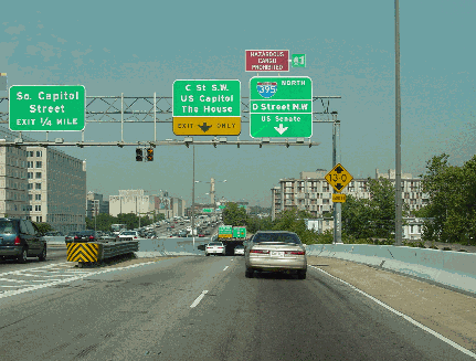
This 2004 photo shows the eastbound Potomac River Freeway (I-66) at the split for the E Street Expressway. Although the sign for the Whitehurst Freeway is technically incorrect, Interstate 66 does continue as the Potomac River Parkway for another three-quarters of a mile before ending at the Whitehurst Freeway (US 29). (Photo by Alex Nitzman, aaroads.com.) |
||

|
EXPANDING THE WHITEHURST AND ADDING I-266 SIGNS: Planning for a northwest extension of the Whitehurst Freeway into Maryland began in 1950, one year after the original stretch of freeway opened. In 1956, the Whitehurst Freeway was added to the Interstate highway system, making it eligible for 90 percent Federal funding for improvements. On the drawing board for the Whitehurst Freeway was an expansion to six or eight lanes along the existing right-of-way. A 1957 planning study by the National Capital Planning Commission (NCPC) called for an eight-lane Potomac River Freeway from the Inner Loop (today's interchange between the Whitehurst Freeway, I-66, and K Street) northwest to the Capital Beltway (I-495). Upon completion, the Whitehurst Freeway was to be re-christened as the Potomac River Freeway. |
||

|
The Potomac River Freeway corridor was one of two corridors considered for the extension of I-70S (today's I-270) into the District of Columbia; the other corridor, which was to be called the Northwest Freeway, was to be routed roughly along Wisconsin Avenue. Strident opposition in Northwest Washington to the proposed I-70S prompted Congress to impose a five-year moratorium on building new freeways west of 12th Street. Eventually, the Northwest routes for I-70S - and later the I-70S North Central extension altogether - were dropped. |
||
|
In 1961, the NCPC considered the Whitehurst-Potomac River Freeway as a connector between downtown Washington and a new Potomac River crossing. The NCPC studied three alternatives, including a new bridge south of the existing Key Bridge and a site near Georgetown Reservoir, but decided upon a site between Glvoer-Archbold Park on the District side and the Spout Run Parkway on the Virginia side - over the Three Sisters Islands, a series of rock formations in the middle of the Potomac River - for the new crossing. The proposed $28.5 million bridge-and-highway combination was planned as a truck route to Virginia, as trucks were prohibited from the Theodore Roosevelt Bridge (I-66) then under construction (at the urging of the NCPC and the National Park Service). |
||
|
The I-266 designation for this plan first appeared in a 1964 study for the proposed Potomac River Freeway and the Three Sisters Bridge. Under the I-266 proposal, the existing Whitehurst Freeway was to serve as the four-lane outbound roadway for the new Potomac River Freeway. A new parallel four-lane elevated roadway was to be built south of the existing freeway to carry inbound traffic. West of the existing end of the Whitehurst Freeway, the eight-lane I-266 was to be extended west on new alignment between the C&O Canal and the Potomac River. An interchange was to be built for the proposed Glover-Archbold Parkway (which was to be built through the eponymously named park) and Palisades Parkway (which was to continue along the Potomac shoreline into Maryland to I-495). At this point, I-266 was to cross the Potomac and the Three Sisters islands into the Virginia, where it was to be built over the Spout Run Parkway en route to the proposed I-66 in Arlington. |
||

|
The cost of rebuilding the pre-Interstate era Whitehurst Freeway as the new I-266 was tagged at $150 million (including condemnation costs), while the cost of building the Three Sisters Bridge was estimated at $36 million. |
||

|
This 1964 map shows the proposed location of I-266 and three alternatives for a new Potomac River bridge and connection to I-66 in Virginia. The central alternative near the Three Sisters Islands was the preferred alternative. (Map by Howard, Needles, Tammen and Bergendoff Consulting Engineers; supplied by Mike Hale.) |
||
|
END OF THE ROAD: By the end of 1964, workers completed a six-block-long viaduct south at the eastern end of the Whitehurst Freeway that was to become part of the new Potomac River Freeway. The viaduct, which was to carry four additional lanes of traffic, also had ramps to I-66 and the North Leg of the Inner Loop (which never was built). Further west, the District government condemned two historic warehouses along the right-of-way for the expanded freeway. However, I-266 appeared to be an on-again, off-again project through much of the 1960's as its funding remained uncertain. |
||
|
Congress ordered work to begin on I-266 under the provisions of the 1968 Federal Highway Act, and cofferdam work began on the Three Sisters Bridge during the fall of 1969. However, a 1970 court injunction halted all work on the bridge. As the bridge's future was being debated, the devastating floods of Hurricane Agnes on June 22, 1972 swept away the preliminary construction work. Although the House of Representatives passed legislation prohibiting court intervention in the construction of the bridge, the provision did not survive in the Senate. |
||

|
SOURCES: The Comprehensive Plan for the National Capital and Its Environs, National Capital Park and Planning Commission (1950); Inner Loop Freeway System, De Leuw, Cather and Company (1955); "Road, Bridge Work Gets $65 Million" by John J. Lindsay, The Washington Post (8/10/1958); "$26.5 Million Budget Sets Up Two Major Roads" by Jack Eisen, The Washington Post (9/25/1958); "$13 Million West Loop To Curve Around School" by James Carberry, The Washington Post (2/19/1959); "First Ramp Contract Awarded for Potomac River Freeway," The Washington Post (7/23/1960); "Contract Awarded for Foggy Bottom Project" by Luther P. Jackson, The Washington Post (10/28/1960); "New Bridge Slated for Early Start" by Willard Clopton, The Washington Post (8/06/1961); "Planners Unveil Georgetown Freeway Plan That Would Wipe Out Part of Industrial Area" by Laurence Stern, The Washington Post (3/02/1962); "Freeway Twists Near Kennedy Center," The Washington Post (2/18/1964); "Opening of Third Ramp, Due in Month, Should Simplify Whitehurst Detours," The Washington Post (11/02/1964); "Foggy Bottom Is a Mammoth Detour" by Helen Dewar, The Washington Post (11/22/1964); "Location Studies, Interstate Route 266," National Capital Planning Commission (1964); "Interstate 266 Route Is Fixed, Now for a Potomac Bridge" by George Lardner, Jr., The Washington Post (3/26/1965); "Expressway Due To Open Monday" by Jack Eisen, The Washington Post (7/10/1965); "A Return to Historic Georgetown," The Washington Post (10/14/1965); "West Leg Freeway Extensions Planned," The Washington Post (1/28/1966); "New City Road Map Would Scrap Freeway Link, Tunnel Potomac" by Jack Eisen, The Washington Post (11/05/1968); "House Clears Path To Build Three Sisters" by Stephen Green, The Washington Post (10/06/1972); "DC Razes Two Historic Buildings" by Timothy S. Robinson, The Washington Post (3/01/1973); "I-66 Corridor Transportation Alternatives Study: Draft Environmental/Section 4(f) Statement," U.S. Department of Transportation (1973); "Three Sisters Highway Project Is Killed Again" by Douglas B. Feaver, The Washington Post (5/13/1977); "History of the Kennedy Center" by Roger Meersman, Records of the Columbia Historical Society (1980); "Remnant of Interstate Going Away" by Barbara Gamarekian, The New York Times (7/28/1985); "$100 Million Given to Kennedy Center" by Robin Pogrebin, The New York Times (12/07/2002); "Kennedy Center Ends a Major Production" by Jacqueline Trescott, The Washington Post (8/10/2005); Mike Hale; Scott Kozel; Douglas A. Willinger. |
||

|
POTOMAC RIVER FREEWAY LINKS: |
||
|
POTOMAC RIVER FREEWAY CURRENT CONDITIONS: |
||

|
OFF-SITE EXIT LISTINGS: |
||
|
VIEW OR SUBMIT YOUR RATING TO RATETHEROADS.COM: |
||

|
Key Bridge (US 29) Three Sisters Bridge (I-266, unbuilt) |
||

|
Back to The Roads of Metro Washington-Baltimore home page. |
||
|
Site contents © by Eastern Roads. This is not an official site run by a government agency. Recommendations provided on this site are strictly those of the author and contributors, not of any government or corporate entity. |
||