 |
|
|
|
|
|
|
|
|
|
|
|
|
|
|
|
|
|
|
|
|
|
|
|
|
|
|
|
|
|
|
|
|
|
|
|
|
|
|
|
|
|
|
|
|
|
|
|
|
|
|
|
|
|
|
|
|
|
|
|
|
|
|
|
|
|
|
|
|
|
|
|
|
 |
|
|
|
|
 |
|
 |
|
|
|
|
|
|
|
|
|
|
|
|
|
|
|
|
 |
|
|
|
|
|
|
|
|
|
|
|
|
|
|
|
 |
|
|
|
|
|
|
|
|
|
|
|
This 2001 photo shows the northbound George Washington Memorial Parkway looking north from a footbridge in Arlington (Rosslyn). Georgetown University is seen across the Potomac River in the distance. (Photo by Nick Klissas.)
|
|
|
|
|
|
|
|
|
 |
|
|
|
|
 |
|
|
|
|
|
|
|
|
|
14.8 miles (23.8 kilometers); northern section
8.4 miles (13.5 kilometers); southern section
1930-1962
|
|
|
|
|
|
|
|
|
 |
|
 |
|
|
|
|
|
Passenger cars only. Trucks prohibited.
Commercial vehicles and buses by permit only.
Height restrictions apply.
|
|
|
|
|
|
|
|
|
|
|
|
|
|
|
|
|
|
|
|
 |
|
|
|
|
|
A PARKWAY FOR THE POTOMAC: Plans for the George Washington Memorial Parkway can be traced back to 1890, when the US Army Corps of Engineers studied three different routes for a proposed "National Road" connecting Washington via the Aqueduct Bridge (now Key Bridge) with Mount Vernon. In 1901, the Senate Park Commission recommended construction the middle of three alignments; this route, which was to be one to two miles west of the current parkway alignment, mostly followed existing routes to reduce costs. The Corps had suggested an easterly riverfront alignment closer to the current route, but this route would have required costly infilling operations.
|
|
|
|
|
|
|
|
|
|
|
|
|
|
|
|
|
|
|
|
|
The promoters of the "National Road" sought the ridgeline route deliberately to take advantage of sweeping vistas of Washington and surrounding areas that could be enjoyed by carriages or on horseback, so access control and grade separation were not concerns. As years went by, what seemed a modest proposal evolved into plans for a wide, paved boulevard flanked by statues, memorials, and trees spaced at regular intervals.
Mount Vernon already was served from Alexandria, Washington, and points north by an electric railway, which had initiated service in 1892. Although it made Mount Vernon more accessible to tourists, it also brought amusement parks and unrestricted commercial development along the Potomac shoreline. As the automobile became the travel mode of choice by the 1920s, the railway went into a slow decline while area roadways became more congested.
|
|
|
|
|
|
|
|
|
|
|
|
Against this backdrop, the Federal Bureau of Public Roads (BPR) authorized construction of the
"Mount Vernon Memorial Parkway" from Memorial Bridge in Arlington south to Mount Vernon in 1928. Although the parkway was to be built along the Potomac shoreline, which had created obstacles for prior planners, generous funding from the Federal government ensured the parkway would have design features for the high-speed automobile age such as extensive infilling and bridges, grade separations, and interchanges instead of intersections.
|
|
|
|
|
|
|
|
|
|
|
|
|
|
|
|
|
|
|
|
|
|
|
|
|
In addition to building a state-of-the-art parkway, the BPR was charged with restoring and preserving the natural landscape, in effect creating a "ribbon park" along the route. The BPR commissioned the design team of Gilmore Clark and Jay Downer, who designed early parkways in Westchester County, New York. Clark and Downer's Bronx River and Saw Mill River parkways were credited with restoring the landscape while providing modern routes for motor vehicles.
In 1930, lawmakers expanded the scope of the Mount Vernon Memorial Parkway when Congress passed the Capper-Cramton Act, which authorized construction of the George Washington Memorial Parkway along both sides of the Potomac from Great Falls south to Mount Vernon (later amended south to Fort Humphreys) on the Virginia side and south to Fort Washington on the Maryland side. With funds scarce at the onset of the Great Depression, the BPR focused on completing the original Arlington-to-Mount Vernon section of the parkway in time for the bicentennial of George Washington's birth in February 1932.
|
|
|
|
|
|
|
|
|
|
|
|
|
|
 |
|
 |
|
|
|
|
|
|
|
|
These 1932 photos show two different locations along the George Washington Memorial Parkway in Arlington (left photo) and Mount Vernon (right photo). Metal lightposts were used along urban stretches while wooden ones were used for less populated areas.
LEFT PHOTO: "View of Washington Monument from the Vicinity of the Capital Overlook, 1932 (HAER VA,30-_,8-212).
RIGHT PHOTO: "Colonial-Style Traffic Sign, Approaching Mount Vernon Terminus, 1932 (HAER VA,30-_,8-215).
(Photos from Historical American Buildings Survey-Historical American Engineering Record, Library of Congress, memory.loc.gov.)
|
|
|
|
|
|
|
|
|
|
|
|
|
|
|
|
|
|
|
|
"Good line is fundamental to good design. The grace and beauty of line in landscape art and good alignment and profile in the engineering science of economic highway design are inseparable." - Wilbur Simonson, landscape architect on the George Washington Memorial Parkway (1932)
|
|
|
|
|
|
|
|
|
|
|
|
DESIGNING A MODERN PARKWAY: Like most controlled-access parkways built in the pre-World War II era, the George Washington Memorial Parkway was built to wed the aesthetics of natural scenery with the safety requirements of high-speed travel. Designers added aerial photography--which was in its infancy--to field measurements to determine the ideal alignment for the parkway that would minimize disruption to the environment while affording motorists with sweeping vistas.
|
|
|
|
|
|
|
|
|
|
|
|
|
|
|
|
|
|
In heavily wooded areas, the trees were incorporated into the design of the parkway to create a sense of intimacy with the nearby woodland, while in grassy areas, wide medians separating the northbound and southbound roadways were featured. Marshy areas demanded the parkway be built as a narrow causeway to minimize environmental impact. Engineers went to great lengths to preserve the existing topography, and where excavation was necessary, made the cuts simulate those found in nature. Landscape architects ordered the use of native and naturalized tree and plant species; over 250,000 trees and plants were planted along the route.
The parkway was built with four 11-foot-wide lanes, which were separated intermittently by a variable median; the right of way ranged from 81 feet to 237 feet. The base of the roadway was formed by a 12-inch-thick mix of clay, sand, and gravel, and topped by a five-inch-thick layer of either concrete slab (used on most stretches) or flexible asphalt (used over wetlands stretches). A nine-foot-wide path also was built within the right-of-way; this path was separated from the parkway by a buffer ranging from 27 feet to 90 feet.
To accommodate higher speeds, engineers planned several grade separations, the most notable of which was a cloverleaf interchange between the parkway and the 14th Street Highway Bridge (now I-395 / US 1), which was the first interchange of its type built by the Federal government. As the approaches to the 14 Street Bridge were expanded over the years, additional ramps were built and the interchange lost its traditional cloverleaf design.
Two traffic circles marked the two original termini of the parkway in Arlington and Mount Vernon. The Arlington circle still exists--providing a grand entrance to Memorial Bridge and Arlington National Cemetery--though depressed bypassed roads were added in 1949 as the parkway was extended north toward the Key Bridge. The Mount Vernon circle--also still in existence--was built on the site of the original turnaround for the electric railway, and there are supplementary roadways at the circle leading to separate parking lots for cars and buses. A third circle located just north of downtown Alexandria was eliminated in 1962 (though a graded railroad crossing still exists nearby).
Perhaps the toughest engineering challenge was building the highway on the unstable soil of the Potomac shoreline. Nearly three miles of the parkway were built on newly placed sand and hydraulic fill obtained from the bottom of the Potomac. About five million cubic yards of fill were pumped via pipelines onto the construction site from two dredges operated by the US Army Corps of Engineers, and additional amounts were pumped out of the Potomac to fill in the area around Reagan National Airport and other subsequent construction and parkway relocation projects. The fill then was graded by a number of bulldozers to form the base of the roadway and adjacent parkland.
|
|
|
|
|
|
|
|
|
|
|
|
|
|
 |
|
 |
|
|
|
|
|
|
|
|
These photos show the attention to detail on the parkway's bridge. Older bridges reflected the classical design conventions of Gilmore Clark and Jay Downer, while newer bridges (as shown on the newer Spout Run span in the right photo) adopted more contemporary designs.
LEFT PHOTO: "Mount Vernon Memorial Highway, Spanning Little Hunting Creek Bridge (HAER VA,30-____,6-D-).
RIGHT PHOTO: "Spout Run Bridge, Spanning Spout Run" (HAER VA-86).
(Photos from Historical American Buildings Survey-Historical American Engineering Record, Library of Congress, memory.loc.gov.)
|
|
|
|
|
|
|
|
|
|
|
|
|
|
|
|
|
|
|
|
ATTENTION TO DETAIL: There are more than 40 bridges along the parkway. The original bridges on the southern section of the parkway--each one with a unique design--have stone-arch styles similar to those found on the Westchester County parkways, reflecting the influence of the Clark-Downer design team. When heavy steel girders were necessary for railroad grade separations, the girders copied the arched design. Concrete and steel-reinforced anchorages served as the foundations where bridges had to be built on less stable soil. Only eight of the original 12 bridges remain. The bridges along the northern section also have unique designs, but these reflected more contemporary design conventions of the 1950s and early 196's and featured more modern materials such as pre-stressed concrete.
|
|
|
|
|
|
|
|
|
|
|
|
|
|
The entire length of the original parkway was illuminated from Arlington south to Mount Vernon. From Arlington to Alexandria, a 21-foot-high "union" metal light standard was used, while in the more bucolic southern stretches toward Mount Vernon, a 20-foot-high cedar wood light standard was used; this wood standard was similar in design to that used on the Westchester County parkways. Over the years, the lightposts were removed as they proved expensive to operate; a few "retro union" and "crookarm" lightposts were installed in recent years between the Memorial Bridge and Reagan Airport to improve safety.
The original parkway also had treated wood guiderail; high rails were used in dangerous areas and low rails were use to discourage parking. In later decades, more modern steel guiderails and three-foot-high continuous stone walls replaced the old wood guiderails.
Wooden bus shelters also were incorporated into the parkway design; they were an unusual feature since most parkways built in this era excluded buses along with trucks. These wooden shelters also were removed years later because of their high maintenance cost.
|
|
|
|
|
|
|
|
|
|
|
|
SLOWING DOWN THROUGH OLD TOWN ALEXANDRIA: The BPR decided to incorporate Old Town Alexandria--which was founded in 1749--into the design of the parkway to emphasize the historic significance of that district. An agreement with the City of Alexandria mandated that buildings along Washington Street (VA 400), which ties together the northern and southern sections of the parkway, adopt context-sensitive historic architecture, and elm trees (now pin oak trees) line the route through Old Town. Brick sidewalks and period-replica lighting also complement the boulevard.
|
|
|
|
|
|
|
 |
|
|
|
|
|
|
|
|
 |
|
|
|
|
|
 |
|
|
|
|
|
|
|
|
This 2001 photo shows the George Washington Memorial Parkway taken from the same location as the initial photo, but this time looking south toward Arlington (Rosslyn). (Photo by Nick Klissas.)
|
|
|
|
|
|
|
|
|
|
|
|
|
|
|
|
|
|
|
|
|
|
|
|
|
|
|
|
|
|
BUILDING THE PARKWAY: Construction of the parkway began on March 19, 1930 in Alexandria. A drought that summer helped accelerated construction, particularly on filling, grading, and drainage work, as well as the construction of several bridges. On September 12 of that year, the first train rolled down the Richmond, Fredericksburg, and Potomac Railroad bridge over the parkway. This bridge remains in active use today and CSX Transportation owns the track rights. Paving work continued in the spring and summer of 1931. The original length of the parkway--from Mount Vernon north to Memorial Bridge--was opened to traffic with a Presidential motorcade on January 17, 1932, one month ahead of schedule. However, the final construction cost of $6.5 million was $2 million above the originally cost estimate.
|
|
|
|
|
|
|
|
|
|
|
|
|
|
EXTENDING THE PARKWAY, DELAYED BY DEPRESSION AND WAR: The long delay in extending the parkway was tied to the lengthy process of acquiring land on both sides of the Potomac; the Capper-Cramton Act called for extension of the parkway not only in Virginia, but also construction of a parallel parkway north and south of the District borders in Maryland. Congress made an appropriation of $33.5 million in May 1930 for the parkway ostensibly to prevent developers and utility company interests from encroaching on the shoreline while preserving the beauty of the Potomac. Congress also authorized $7.5 million to the National Capital Park and Planning Commission (NCPPC) for land acquisition; the states of Virginia and Maryland were to match this amount. Given finances strained by the Great Depression and reluctance by members of Congress to pay for projects not in their districts, further progress had to wait until after the Depression and World War II.
One part of the parkway where there was progress was the section from Memorial Bridge north past Key Bridge to Spout Run. In 1935, the National Park Service (NPS) acquired a 1-1/4 mile-long parcel from Memorial Bridge north to Key Bridge for a half-million dollars; part of this amount included acquisition of a powerhouse for the Washington and Old Dominion Railway. However, construction of this section did not take place for at least another decade.
PROGRESS AFTER THE WAR: Construction resumed on a two-mile section of the George Washington Memorial Parkway immediately after the end of World War II. This section, which included the building of a short spur called the Spout Run Parkway, was completed in the spring of 1949. (A ramp from the Key Bridge circle to the northbound parkway was not added until the route was extended north of Spout Run in the late 1950's.)
Given the rapid postwar development of the area, planners had a sense of urgency to procure funds for acquiring land and extending the parkway north toward the then-proposed Capital Beltway (I-495) and eventually to Great Falls. Two seminal events in the 1950's set the tone for extending the parkway from Arlington into Fairfax County:
1954: The Federal Highway Aid Act allowed contract authorization for national parkways for three years, thus allowing officials to coordinate planning and construction within a definite timeframe. As the project costs became clearer, this increased pressure for officials to obtain Congressional appropriations and matching state funds for land acquisition and construction.
1955: The Central Intelligence Agency (CIA) announced plans to locate their new headquarters in Langley, citing the close proximity to the proposed parkway as an advantage to other sites that were considered. The NPS estimate the cost to extend the parkway five miles from the Spout Run Parkway north to VA 123 (Chain Bridge Road) near Fort Marcy Park at $8.5 million; Virginia and Fairfax County committed another $825,000 for land acquisition along this section.
The section between the Spout Run Parkway and VA 123 was opened to traffic on November 3, 1959. It was the first section of the George Washington Memorial Parkway to open under the Federal Highway Act of 1954.
ONTO THE BELTWAY: A roadblock to extending the George Washington Memorial Parkway to the Capital Beltway arose in 1959 when concerns arose over the proposed alignment. The NPS and other agencies recommended a new alignment that moved away from the immediate Potomac shoreline because of the steep bluffs and the numerous streams that would need to be crossed. The revised alignment had only two stream crossings; it also included new parkland (Turkey Run Recreational Area) with a dedicated grade-separated interchange. There also was a new dedicated "trumpet' interchange for the CIA parking lot.
The final three and one-half miles of the parkway were completed in 1962. This coincided with the completion of the Capital Beltway through the area, as well as the opening of the American Legion Bridge (I-495).
|
|
|
|
|
|
|
|
|
|
|
|
|
|
|
 |
|
|
|
|
|
|
|
|
This 2004 photo shows the George Washington Memorial Parkway looking north near Fort Marcy Park in Langley. (Photo by Laura Siggia Anderson.)
|
|
|
|
|
|
|
|
|
|
|
|
|
|
|
|
|
|
|
|
ADAPTING TO THE MODERN ERA: Over the years, the function of the George Washington Memorial Parkway shifted from recreational route to commuter route, and the parkway soon become plagued by chronic congestion, particularly in the area of the Key Bridge. In 1974, officials considered closing the parkway to all vehicles except for buses and carpools between VA 123 and the Key Bridge; this proposed rule would have been similar to the restriction currently in place along the "inside the Beltway" section of I-66. This plan never was implemented.
|
|
|
|
|
|
|
|
|
|
|
|
|
|
The changing values of the 1970s included a shift in focus to non-motorized transportation, and the NPS revived old plans to address this concern. Separate bridle and pedestrian paths were included in the 1890 and 1930 plans for the original parkway, and short paths were built at discontinuous locations, but a full-length pedestrian and bicycle path did not come until the 1970s. Construction of bike path began in 1971 and initial section from the Memorial Bridge south to Mount Vernon was completed in 1974. This path was extended north to the Key Bridge in 1988; it included an overpass to Rosslyn and a pedestrian bridge across the Potomac to Theodore Roosevelt Island. Today, the path extends 18.5 miles between Mount Vernon and the Key Bridge. One organization called FairfaxTrails.org proposed a 12-mile extension of the multi-use path mostly along the parkway right-of-way, except between the palisades area between the Key and Chain bridges where the path would traverse existing streets.
MORE RECENT IMPROVEMENTS: Between 1994 and 1996, engineers extended acceleration and deceleration lanes along a mile-long stretch of the parkway from the Theodore Roosevelt Bridge (I-66) north to the Spout Run Parkway. To accommodate the extra lanes, a narrow, masonry-covered median barrier replaced the tree-line median strip; new through traffic lanes were placed on either side of the barrier while the acceleration-deceleration lanes were extended. Additional excavation and tree removal took place at the ramps for the Theodore Roosevelt Bridge.
In 2008, work began on a major project to replace the Humpback Bridge across Boundary Channel. The bridge and its approaches are plagued by insufficient sight distances that result in frequent accidents, about 20% of which cause bodily injury. Accidents also occur because of the bridge's close proximity just north of the cloverleaf interchange with I-395 (Shirley Highway); the lack of acceleration-deceleration ramps--which was modified only slightly from the interchange's original 1930s design--has resulted in numerous accidents and often causes delays on the 14th Street Bridge. Pedestrians and cyclists also are in danger because they are confined to a narrow sidewalk without any barrier separating them from parkway traffic on the bridge; they also must cross four lanes of parkway in order to access the Columbia Island Marina from the multi-use trail. The project includes the following improvements:
The existing Humpback Bridge will be replaced with a wider span that would accommodate five lanes of traffic instead of four. The extra lane would serve as an extended acceleration lane for motorists on the northbound George Washington Memorial Parkway from southbound I-395. (There currently are no plans to extend the deceleration lane for motorists exiting the southbound parkway onto southbound I-395.) The new bridge would be slightly longer at 244 feet from anchorage to anchorage.
The new bridge will have a similar stone-arch exterior design to the existing span and be built with similar materials. However, there would be two smaller flanking arches to accommodate trails in addition to the main 100-foot arch across Boundary Channel; pedestrians and cyclists no longer would have to cross the parkway at the crosswalk near the Navy and Marine Memorial.
The grade of the parkway approaches would be raised gradually on either side of the bridge to improve sight distance.
Decorative stone barriers would be erected along the parkway median, as well as between the parkway and the multi-use trail.
The northbound vehicle entrance into the Columbia Island Marina and Lyndon B. Johnson Memorial Grove parking areas would be closed.
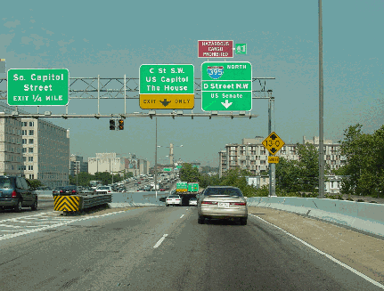
The entire length of the existing parkway is in Virginia except for a 1.4-mile-long stretch through Lady Bird Johnson Memorial Park; this stretch actually is located in the District of Columbia. According to the Federal Highway Administration (FHWA), the George Washington Memorial Parkway carries between 15,000 and 25,000 vehicles per day (AADT) on the Mount Vernon-to-Alexandria section. In the area of Reagan National Airport, the parkway carries approximately 50,000 vehicles per day; from the airport north to VA 123, the parkway handles between 70,000 and 80,000 vehicles per day. From VA 123 north to the Capital Beltway, the northernmost stretch of parkway carries about 50,000 vehicles per day. In 2003, the Virginia Department of Transportation (VDOT) assigned the unsigned VA 90005 designation for not only the parkway, but also Washington Street through Alexandria, which already is signed as VA 400.
|
|
|
|
|
|
|
|
|
|
|
|
|
|
|
 |
|
|
|
|
|
|
|
|
This 2001 photo shows the George Washington Memorial Parkway looking south at the Humpback Bridge over Boundary Channel in Arlington. Note the lack of physical separation between the northbound lanes of the parkway and the multi-use trail. A $35 million bridge replacement project will add a northbound acceleration lane and a decorative stone barrier to separate the trail from the parkway. (Photo by Nick Klissas.)
|
|
|
|
|
|
|
|
|
|
|
|
|
|
|
|
|
|
|
 |
|
|
|
 |
|
|
|
|
|
|
|
|
|
A BYPASS FOR OLD TOWN ALEXANDRIA: Beginning in 1959, the Mass Transportation Survey authored by the National Capital Planning Commission (NCPC) recommended building a relocated George Washington Memorial Parkway elevated along the city's waterfront to connect the existing northern and southern sections. Planners sought to relieve congestion along Washington Street and other streets in Old Town, but residents fought the elevated parkway on the grounds that it would block their view of the Potomac. The proposal had fallen out of favor by the mid-1960s as the city's planning commission envisioned replacing dilapidated warehouses and docks with waterfront condominiums and other attractions.
|
|
|
|
|
|
|
|
|
|
|
|
|
|
EXTENDING SOUTH TO WOODLAWN: In 1960, the NPS approved a three-mile extension of the George Washington Memorial Parkway south to US 1 (Richmond Highway) at Woodlawn Plantation. However, it had become increasingly difficult for the NPS to acquire the right-of-way given escalating land values, and by the end of the decade the NPS abandoned plans for the Woodlawn extension.
The Woodlawn estate originally was part of George Washington's much larger Mount Vernon estate; it stayed in the Washington family until it was sold in 1846 to two Quaker families from New Jersey and Pennsylvania, which set up the estate as a "free labor colony" as a rebuke to slavery. Not surprisingly, Woodlawn was a target for periodic Confederate raids during the Civil War. The property remained in private hands until 1952, when the property was sold to the National Trust for Historic Preservation.
AND NORTH TO GREAT FALLS: The land around Great Falls originally was purchased by the Potomac Edison Power Company (PEPCO) for the express purpose of building a hydroelectric dam. PEPCO had leased the land back to the Fairfax County Park Authority, which maintained a public park and operated a popular carousel on the land. The NPS did not want the site to become a dam or be sold to developers, but finances remained tight well into the postwar era.
In the late 1950s and early 1960s, planners debated whether to extend the George Washington Memorial Parkway north along a shoreline route or to reroute the parkway along the existing VA 193 (Georgetown Pike) to the park entrance. In 1966, the NPS acquired the 800-acre Great Falls PEPCO property, forever keeping the land off limits to developers. The NPS opened a visitor center in 1968, and with additional acreage purchased, this appeared to remove the last obstacle toward extending the parkway.
In the early 1970s, environmentalists blocked successfully any provision for a Potomac River crossing for the Outer Beltway north of the American Legion Bridge (I-495). With the northerly Potomac crossing blocked, it did not take long for the NPS to abandon plans to extend the George Washington Memorial Parkway on the Virginia side of the Potomac--and the Clara Barton Parkway on the Maryland side--north to Great Falls.
|
|
|
|
|
|
|
|
|
|
|
|
|
|
|
|
|
|
|
|
|
|
|
 |
|
|
|
|
|
SOURCES: "Memorial Highway Work Is Underway," The Washington Post (3/20/1930); "Memorial Highway Work Accelerated," The Washington Post (9/28/1930); "Progress Shown on Mount Vernon Memorial Highway," The Washington Post (5/31/1931); "Memorial Bridge Opened Informally," The Washington Post (1/17/1932); "WRT To Operate Buses on Highway," The Washington Post (8/12/1932); "Extension To Aid New Subdivisions Along Parkway," The Washington Post (11/07/1948); "Spout Off," The Washington Post (12/22/1950); "Fairfax Heads Seek To Lure CIA Facility," The Washington Post (11/17/1955); "New George Washington Parkway Section Gives Autoists Novel Vistas" by Muriel Guinn, The Washington Post (11/14/1958); "New Parkway Opens to Old Traffic Jam" by John J. Lindsay, The Washington Post (11/04/1959); "Extension of Parkway Is Endorsed," The Washington Post (6/11/1960); "Alexandria Discards Riverside Parkway" by Walter B. Douglas, The Washington Post (1/01/1965); "Bike Path To Extend South of Alexandria" by Paul Hodge, The Washington Post (11/11/1971); George Washington Memorial Parkway Documentation Project, National Parks Service-US Department of the Interior (1994); "Overhaul of GW Bridge To Hamper Commute" by Mark Berman, The Washington Post (11/22/2007); FairfaxTrails.org; HistoricAerials.com; National Park Service; National Trust for Historic Preservation; Nick Klissas; Alex Nitzman; Alexander Svirsky; Mike Tantillo.
VA 400 shield by Barry L. Camp.
Lightpost photos by Steve Anderson.
|
|
|
|
|
|
|
|
|
|
|
|
|
|
|
|
|
|
|
|
|
|
|
|
|
|
|
|
GEORGE WASHINGTON MEMORIAL PARKWAY CURRENT TRAFFIC CONDITIONS:
|
|
|
|
|
|
|
|
|
|
|
|
 |
|
|
|
|
|
GEORGE WASHINGTON MEMORIAL PARKWAY VIDEO LINK:
|
|
|
|
|
|
|
|
|
|
|
 |
|
|
|
|
|
THE EXITS OF METRO WASHINGTON-BALTIMORE:
George Washington Memorial Parkway exit list by Steve Anderson.
|
|
|
|
|
|
|
|
|
|
|
|
 |
|
|
|
|
|
|
|
|
 |
|
|
|
|
|
|
|
|
|
|
|
|
Site contents © by Eastern Roads. This is not an official site run by a government agency. Recommendations provided on this site are strictly those of the author and contributors, not of any government or corporate entity.
|
|
|
|
|
|
|
|
|
|