
|
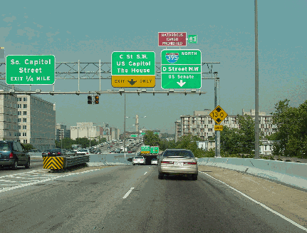
This 2004 photo shows the northbound Center Leg Freeway (I-395) approaching the Mall tunnel. (Photo by Jim K. Georges.) |
||

|
TAPPING INTO THE HEART OF THE DISTRICT: Early planning for the Center Leg Freeway began in 1946 when the National Capital Planning Commission (NCPC) issued its study, "Transportation Plan for Washington." This study recommended a north-south freeway connecting the proposed K Street Freeway with the South Capital Street (Frederick Douglass) Bridge and the Suitland Parkway. The freeway ultimately was scrapped south of the east-west freeway link at F Street (Southeast-Southwest freeways). |
||
|
What eventually became known as the Center Leg Freeway received a boost when a 1955 report by De Leuw, Cather and Company proposed the link as part of the $272 million, 18-mile Inner Loop project in a 1955 report. This report proposed two alternatives for the 1.7-mile-long route: |
||
|
In 1958, the Center Leg Freeway received the I-95 designation. The I-95 route through the District was to comprise the Center Leg and Southwest freeways, as well as unbuilt sections of the North Leg, North Central, and Northeast freeways. |
||

|
CRITICS CALL FOR ALTERNATIVES: The Center Leg Freeway plan drew criticism from the National Parks Service, which argued that construction would require the removal of large old trees, and from the office of the Architect of the Capitol, which questioned the need for a freeway to cross Capitol grounds in any manifestation. Some members of Congress opposed the Center Leg routing altogether, arguing that its construction would spoil the Capitol grounds and suggesting that I-95 be routed along the proposed East Leg Freeway instead. House Speaker Sam Rayburn (D-Texas) raised concerns that the freeway would run close to the House office building planned for 1st Street SW that ultimately would bear his name (the building opened in 1965). |
||
|
Some District officials argued for a more westerly routing for the Center Leg between 4th Street and 5th Street NW to better serve downtown. This routing first appeared in a 1961 report, but was dropped shortly thereafter. |
||

|
This diagram from the 1955 De Leuw, Cather and Company report shows the original routing of the Center Leg Freeway. Note the gentle curve of the original alignment underneath the National Mall. This alignment was changed in favor of a straighter, less expensive alignment in 1965. (Map from Douglas A. Willinger.) |
||

|
FINAL ROUTE UNDER THE MALL APPROVED: On November 1, 1965, a coalition of Federal and District officials, including the Commission of Fine Arts, the National Parks Service, and the Architect of the Capitol, approved the following plan for the eight-lane Center Leg Freeway from the Southeast-Southwest freeways to Massachusetts Avenue: |
||
|
The twin-tube, cut-and-cover tunnel measures 3,500 feet long; each tube measures 66 feet from wall to wall. There are 28 chain-driven fans (16 for fresh air and 12 for exhaust) and seven-and-one-half miles of fluorescent light tubing. CONSTRUCTION PROCEEDS, BUT OPENING DELAYS CREATE "A LOOPHOLE BIG ENOUGH TO DRIVE THROUGH:" Construction of the Center Leg began in 1966, extending the short freeway stub built between 1961 and 1963 to connect the Southeast-Southwest freeways to D Street SW. By the spring of 1972, after six years of street disruptions, much of the work on the Center Leg had been completed. The cost of the initial section was $81 million - including land takings and air rights - in 1972 dollars. However, delays in final paving and electrical work prompted District officials to create 600 temporary parking spaces along a four-block-long depressed stretch of freeway from D Street north to the Massachusetts Avenue terminus. Students at nearby Georgetown University Law School, finding a flaw in the city's informal agreement in what The Washington Post called "a loophole to drive hundreds of cars through," sold 600 parking decals, more than the 100 that the school was allocated. According to the Post, the law school pocketed $900, more than the $600 assessment from the city, giving it a small profit. THE CENTER LEG OPENS, BUT REST OF I-95 CAST INTO DOUBT: The Center Leg Freeway, originally scheduled to open prior to Inauguration Day, 1973, was opened to traffic north to the E Street NW on November 5, 1973. By the time the Center Leg opened, the future of the rest of the I-95 routing through Washington was thrown into uncertainty as most of the remaining Inner Loop network, the North Central Freeway, and the Northeast Freeway were canceled four months earlier. |
||
|
For about three years, District officials planned to extend I-95 from the Center Leg through the proposed New York Avenue Industrial Freeway and the existing Baltimore-Washington Parkway toward the Capital Beltway. However, the 1976 cancellation of the New York Avenue Industrial Freeway dashed these plans. In 1977, the Center Leg received a new designation - Interstate 395 - with a revised northern terminus at a T-intersection with New York Avenue (US 50). |
||


|
This 1992 photo shows the Center Leg Freeway (I-395) looking north toward the Mall tunnel at the C Street SW portal. (Photo by Jack Boucher, Historical American Buildings Survey-Library of Congress, Photo ID# HABS, DC,WASH,615-2.) |
||
|
THE SECOND SECTION OF THE CENTER LEG: The $37 million Center Leg Freeway extension was to include construction of a 1,250-foot-long tunnel stretching from Massachusetts Avenue north to K Street NW. A 133-unit apartment building (operated by Mount Carmel Baptist Church for low-to-moderate income families displaced by freeway construction) and a multi-story parking garage were to be built atop the Center Leg. An additional 168 units were to be built under a 1967 agreement, but such plans never were realized. Two ventilation towers were built for the tunnel: one integrated into the apartment building; the other integrated into the parking structure. |
||
|
The freeway was designed for eight lanes of through traffic. However, there are only four traffic lanes (two in each direction through the tunnel); the pavement for the four additional travel lanes near the south tunnel portal and through the tunnel is cordoned off by concrete "Jersey" barriers. I-395 emerges from the north portal of the tunnel with four travel lanes and grassy buffer areas, which were reserved for connecting ramps to the never-built North Leg Freeway (I-66). |
||

|
This 2004 photo shows the northbound Center Leg Freeway (I-395) approaching the Massachusetts Avenue tunnel portal. The northern terminus of I-395 at New York Avenue is less than one-half mile ahead past the tunnel. Note how the two additional travel lanes in each direction are separated by concrete "Jersey" barriers. (Photo by Jim K. Georges.) |
||


|
This artist's depiction from the 1971 DeLeuw, Cather Associates and Harry Wesse & Associates report shows the proposed "Interchange A" between the Center Leg and North Leg freeways. Center Leg Freeway traffic is shown in the tunnel at the center of the depiction. (Graphic supplied by Douglas A. Willinger.) |
||
|
STUB TO NORTH LEG LEFT UNBUILT: As planned originally in the 1950's, the Center Leg Freeway was to have extended north to an "Interchange A" with I-66 (North Leg, west section) in the area of P Street NW. By the 1960's, as attention shifted from building I-66 in an open trench to building it in a K Street tunnel, planners refined the Center Leg's northern terminus such that it would end at a "directional-T" interchange at New York Avenue. Revised plans from 1971 called for the then-proposed I-95 continuing from the Center Leg through a mixed tunnel-and-trench freeway along New York Avenue. |
||
|
EVERYTHING OLD IS NEW AGAIN: Plans for the Center Leg Freeway-New York Avenue tunnel connection lay dormant for nearly a quarter century until 1996, when Mayor Barry - who rose in prominence in the late 1960's and early 1970's in Washington's anti-freeway movement - initiated studies on a tunnel connection. District officials reconsidered tunnel plans in the face of not only growing congestion, but also chronic safety concerns: the northern terminus of I-395 at New York Avenue currently ranks as the fourth-worst intersection in the District, according to DDOT data. |
||

|
This 2002 photo shows the northbound Center Leg Freeway (I-395) approaching its northern terminus at New York Avenue. The grassy buffers were set aside for future lane additions and connecting ramps to a proposed I-66 extension. (Photo by Jim K. Georges.) |
||


|
CONNECTING TO THE "NEW" NORTH LEG: A new below-grade interchange should be built to connect the northern terminus of the Center Leg Freeway with a new North Leg Freeway (proposed I-66) underneath K Street and New York Avenue. |
||

|
SOURCES: The Comprehensive Plan for the National Capital and Its Environs, National Capital Park and Planning Commission (1950); Inner Loop Freeway System, De Leuw, Cather and Company (1955); "Inner Loop Delay Laid to Stewart," The Washington Post (9/24/1960); "New Expressway Plans Would Shift Mall Tunnel," The Washington Post (2/04/1961); "Interstate 95 DC Route Pinpointed" by James R. Carberry, The Washington Post (3/26/1961); "Studies on DC Center Leg Freeway May Start This Year, Official Reports," The Washington Post (6/29/1963); "Inner Loop Mall Tunnel Is Approved" by Jack Eisen, The Washington Post (12/31/1963); "Tunnel Under Mall Moves Step Nearer to Senate Approval" by Jack Eisen, The Washington Post (6/20/1964); "City on Brink of 'Tunnel Era' for Its Roads" by Dan Morgan, The Washington Post (5/24/1965); "Center Leg's Northern Portion Approved by Plans Units 5-4" by William Clopton, The Washington Post (6/11/1965); "New Labor Department Building Will Be Built Above Mall Outlet Tunnel" by Dan Morgan, The Washington Post (10/07/1965); "East Mall Reflecting Pool Planned" by Paul Richard, The Washington Post (11/02/1965); "Start of Center Leg Freeway Work Will Focus on D and E Street Bridges" by Paul Richard, The Washington Post (2/20/1966); Inner Loop Freeway System, DeLeuw, Cather Associates and Harry Wesse & Associates (1971); "New Use for a Freeway" by Donald P. Baker, The Washington Post (12/16/1972); "Sophisticated District Freeway To Open Soon" by Major C. Wells, The Washington Post (10/14/1973); "Freeway Deck for Homes Set" by Eugene L. Meyer, The Washington Post (11/14/1974); "Judge Orders Halt in Work on Freeway" by Eugene L. Meyer, The Washington Post (4/29/1975); "No New Freeways Slated for District" by Douglas B. Feaver, The Washington Post (11/30/1978); "DC Freeway to Nowhere: Free Parking" by Ed Bruske, The Washington Post (4/10/1982); "$2.2 Million Proposed for Freeway Link" by Ed Bruske, The Washington Post (5/21/1982); "City Urged To Upgrade 3rd Street Tunnel Safety Devices" by John Burgess, The Washington Post (1/04/1983); "After Eight-Year Wait, Last Segment of Center Leg Freeway Nears Completion" by Stephen J. Lynton, The Washington Post (12/10/1986); "DC Freeway Stretch Will Open Today" by John Lancaster, The Washington Post (2/06/1987); "Plan for Complex Over I-395 Is Criticized" by Michael Abromowitz, The Washington Post (1/18/1990); "Developer Triumphs Again" by Sean Madigan, Washington Business Journal (2/27/2004); "New York Avenue Traffic Plans Spark Concerns: DC Residents React to Draft Proposals" by V. Dion Haynes, The Washington Post (6/26/2005); New York Avenue Corridor Study, District of Columbia Department of Transportation (2006); Scott Kozel; Alexander Svirsky; Douglas A. Willinger; William F. Yurasko. |
||
|
CENTER LEG FREEWAY LINKS: |
||
|
CENTER LEG FREEWAY VIDEO LINK: |
||
|
CENTER LEG FREEWAY CURRENT CONDITIONS: |
||

|
OFF-SITE EXIT LISTINGS: |
||
|
VIEW OR SUBMIT YOUR RATING TO RATETHEROADS.COM: |
||

|
Back to The Roads of Metro Washington-Baltimore home page. |
||
|
Site contents © by Eastern Roads. This is not an official site run by a government agency. Recommendations provided on this site are strictly those of the author and contributors, not of any government or corporate entity. |
||