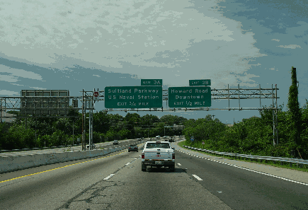
This 2004 photo shows the southbound Anacostia Freeway (I-295) approaching EXIT 3 (Howard Road and Suitland Parkway). (Photo by Jim K. Georges.)
CONNECTING SOUTHEAST D.C. VIA THE ANACOSTIA WATERFRONT: Conceived by the National Capital Park and Planning Commission (NCPPC) in 1950 as part of the metropolitan area's postwar traffic plans, the Anacostia Freeway was conceived to connect the Baltimore-Washington Parkway (MD 295) via Kenilworth Avenue, providing access to downtown Washington, Anacostia Naval Station, Bolling Air Force Base, and the Capital Beltway (I-495 and I-95). The Anacostia Freeway was among the freeways to be built under a ten-year program outlined in the NCPPC's 1952 report, "Recommended Highway Improvement Program," and was dealt with separately in a 1955 NCPPC report.
In 1955, district officials approved construction of the northerly stretch of the freeway from the East Capitol Street Bridge to Suitland Parkway. District and Maryland officials approved construction of the remainder of the freeway in 1956. That year, the proposed route received a boost when the southern portion of the freeway from the 11th Street Bridges to the Capital Beltway became eligible for 90 percent Federal funding under the Interstate highway program; the remainder of the freeway's $20 million cost was to be covered from Maryland and District of Columbia funds. Costs for the remaining section of the Anacostia Freeway - including the Kenilworth Avenue section north to the Baltimore-Washington Parkway - was split evenly between the Federal government and the District government.
District officials originally proposed an I-63 designation for the Anacostia Freeway, but the American Association of State Highway Officials (AASHO) denied this request. AASHO proposed an I-195 designation for the route, but because it was to connect the Capital Beltway with a proposed "Inner Loop," District Officials proposed an I-295 designation. AASHO accepted this re-submission in July 1958. (The I-295 designation continues across the 11th Street Bridges, while the DC 295 designation continues north along the Anacostia and Kenilworth Avenue freeways.)
Initial work on the Anacostia Freeway began in 1957 as a southerly extension of the Kenilworth Avenue Freeway, which at the time was nearing completion. Because the freeway was built on right-of-way for the unbuilt controlled-access Shepard Parkway, land acquisition was not much of an issue.
The freeway was built with four lanes (two in each direction) through much of its length, but an additional travel lane in each direction was provided from the area of Bolling Air Force Base north to the 11th Street Bridges. South of Bolling Air Force Base, space was reserved in the grassy median for an additional lane which was to have been built after 1975.
Unlike the older overpasses on the Kenilworth Avenue Freeway to the north, bridges along the Anacostia Freeway reflected more contemporary Interstate-era design. A short section of freeway was built on fill over the east bank of the Potomac River just inside the District border north of the Capital Beltway.
The original 7.8 miles of the Anacostia Freeway was opened to traffic on August 7, 1964 upon completion of the Capital Beltway to the south. By the time it opened, construction costs had increased from $20 million to $36 million. In 1990, the four-lane freeway was extended 1.7 miles to the southeast to connect with MD 210 (Indian Head Highway) in Oxon Hill. The newly extended freeway section, which parallels the existing Capital Beltway to its immediate south, required the reconstruction of several ramps on the beltway at EXIT 2 (I-295) and EXIT 3 (MD 210). However, the Maryland State Highway Administration (SHA) considers this extension a freeway ramp, and thus is not counted in the total mileage for I-295.
When the Anacostia Freeway opened, it was expected to carry around 25,000 vehicles per day (AADT). According to District and Maryland highway officials, the freeway now carries approximately 75,000 vehicles per day (AADT) in Maryland and 95,000 vehicles per day near the Frederick Douglas and 11th Street Bridges.
The District of Columbia Department of Transportation (DCDOT) replaced the freeway bridge over Oxon Cove, which is located about 800 feet north of the District of Columbia-Maryland border, in the early 2000s.
CHANGES FOR INTERCHANGES: The following interchange projects are planned for the Anacostia Freeway:
At the southern terminus in Oxon Hill, the Maryland State Highway Administration (SHA) is rebuilding the ramps between I-295, the Capital Beltway (I-95 and I-495), and MD 210. New ramps are being built for the proposed 300-acre National Harbor development immediately south of the interchange, and right-of-way is being preserved for future HOV lane connections. Part of the much larger $2.4 billion Woodrow Wilson Bridge replacement project, the interchange reconstruction is being completed in stages through 2011.
DCDOT replaced the I-295 bridges over South Capitol Street near Bolling Air Force Base. The project was finished in 2009.
Ramps connecting to the Suitland Parkway and the Frederick Douglass (South Capitol Street) Bridge may be rebuilt as part of the $340 million Frederick Douglass Bridge replacement project. Work is not expected to start until at least 2011.
A major reconstruction is underway for the interchange between the Anacostia Freeway (I-295 and DC 295) and the 11th Street Bridges. The twin bridges, which carry the I-295 designation, carry eight lanes of traffic between the Anacostia Freeway and the Southeast Freeway (I-695). Currently, ramps exist between the bridge (I-295 connector) and I-295, but there is no connection between the bridge and DC 295 because the Barney Circle extension of I-695, which was to supply the missing movements between downtown and the Baltimore-Washington Parkway, never was built. A newly built directional "Y"-interchange would supply the "missing moves" between the Anacostia Freeway and the bridge. The $465 million bridge and interchange replacement project began in December 2009 with a tentative completion date of 2014; the "missing moves" part of the project could be finished as early as 2012.
An interchange may be built to connect to the proposed Massachusetts Avenue Bridge. Part of the "Kenilworth Avenue Corridor" study, this plan is only in the preliminary design stage.
Long-range plans call for the construction of HOV lanes in the center median of the Anacostia Freeway from the 11th Street Bridges. They also call for integrating the freeway into the redevelopment Anacostia waterfront through landscape design elements such as decorative lighting and rebuilt overpasses. A more ambitious proposal from the National Capital Planning Commission (NCPC) advocates burying the freeway along the Anacostia waterfront.
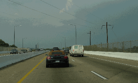
This 2004 photo shows the northbound Anacostia Freeway (DC 295) just south of East Capitol Street. A ramp stub remains on the southbound side for the unbuilt Southeast Freeway-Barney Circle extension (I-695), which was canceled in 1996. (Photo by Jim K. Georges.)
"The only thing who could conceive of this thing could be planners. It's planning for massive development we don't want or need." - Charles Blumenthal, member of the Maryland House of Delegates, Prince Georges County (1979)
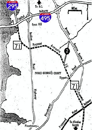
A SOUTHERN EXTENSION? As designed and built in the early 1960's, the original interchange between the Anacostia Freeway and the Capital Beltway was a fully directional cloverleaf with graded ramps for a future southern extension of I-295. According to the 1950 NCPPC master plan, the Anacostia Freeway was to continue south of the Capital Beltway and southern Prince Georges County along the east bank of the Potomac River. Early plans called for the five-mile-long extension to be built as a part of the "George Washington Memorial Parkway" system toward Fort Washington Park.
Around this time, Maryland officials had a competing plan to build a "Southeast Freeway" in the north-south corridor between Indian Head Highway (MD 210) and Branch Freeway (MD 5) Leaving the District of Columbia through Wheeler Road, the four-to-six-lane freeway was to intersect the Capital Beltway near EXIT 4 (MD 414 / St. Barnabas Road) and Rosecroft Raceway. The freeway was to continue south past Piscataway Road (MD 223) toward an interchange with the Outer Beltway, and may have been planned as far south as US 301 in Calvert County.
In the face of community opposition from those who opposed a waterfront route along the southern Potomac (for the Fort Washington route) and those blocking an expressway entry into Washington via Wheeler Road (for the original Southeast route), the NCPPC devised a new "Anacostia-Southeast" alternative in 1969 that combined aspects of the two highways:
Beginning at the Capital Beltway in Oxon Hill, the Anacostia Freeway was to continue south for about one and one-half miles along the Potomac before veering east.
The freeway was to cross Indian Head Highway (MD 210) near Kerby Hill Road and Livingston Road in Fort Washington, and continue east until the vicinity of Bock Road where it was to veer southeast.
The freeway was to cross Piscataway Road (MD 223) in the vicinity of Tippett Road in Clinton.
There was to have been an interchange between the Anacostia Freeway and the Outer Beltway in the area of Brandywine in southern Prince Georges County. The route of the freeway south of the Outer Beltway was less certain, but it may have continued south to US 301 in Waldorf.
According to The Washington Post, the proposed Anacostia-Southeast alignment was designated MD 71 on a Prince Georges County planning map. There were no plans to extend the I-295 designation south of the Capital Beltway or to re-use the MD 295 designation for the extension.
The Anacostia Freeway extension remained on the county's master plan as late as 1979, but citizen opposition and budget constraints stopped most new projects from getting off the ground. The $2 billion National Harbor mixed-use project precludes a southerly extension of the freeway, but the project could be home to the proposed terminus of a light rail line originating in Washington.
This map from the November 27, 1969 edition of The Washington Post (""Prince Georges Highway Put Into Reverse" shows the proposed route of the Anacostia-Southeast alignment.
A Prince Georges County master plan map showed the extension with the MD 71 designation. The MD 71 designation was used twice in the state before it was retired in 1960.
The freeway was removed from the Prince Georges County master plan sometime after 1979.
EXPAND THE ANACOSTIA: The Anacostia Freeway should be rebuilt in a 3-1-1-3 configuration with HOV (or HO/T) lanes in the center median from the Capital Beltway north to the 11th Street Bridges. The development of the National Harbor project is likely to intensify congestion along the east bank of the Potomac, necessitating expansion of the existing freeway. The proposed Metro-Anacostia Corridor light rail project should be incorporated into the expansion.
EXTEND EXIT NUMBERING: The exit numbering scheme for the I-295 section of the Anacostia Freeway should be extended north along DC 295 (Anacostia and Kenilworth Avenue freeways).
SOURCES: The Comprehensive Plan for the National Capital and Its Environs, National Capital Park and Planning Commission (1950); "Planners Approve Half of Anacostia Freeway," The Washington Post (5/07/1955); "Anacostia Freeway Construction Is Urged" by Robert C. Albrook, The Washington Post (1/01/1956); "Anacostia Freeway Plans Meet Protest" by Robert C. Albrook, The Washington Post (5/05/1956); "Freeway Opens Here on Friday" by William Clopton, The Washington Post (8/04/1964); "Anacostia Freeway Now Open All the Way," The Washington Post (8/08/1964); "Prince Georges Plans Shift in Southeast Freeway" by Douglas Watson, The Washington Post (3/25/1969); "Prince Georges Highway Put Into Reverse" by Douglas Watson, The Washington Post (11/27/1969); "Plan Drawn for Development of Southwest Prince Georges" by Jackson Diehl, The Washington Post (9/21/1979); "Dr. Gridlock: Namely, Confusion," The Washington Post (7/07/1989); "Time To Change Course: Anacostia Waterfront Holds Big Hopes for City's Future" by Arthur Santana, The Washington Post (4/03/2003); "11th Street Bridge: Environmental Impact Statement," U.S. Department of Transportation and District of Columbia Department of Transportation (2005); "Kenilworth Avenue Corridor Transportation Study," District of Columbia Department of Transportation (2005); "South Capitol Street Bridge Study," District of Columbia Department of Transportation (2005); "For Commuters, a New Way To Travel Through the District" by Lyndsey Layton, The Washington Post (4/13/2006); "11th Street Bridges Assessment Digested" by Jacqueline Dupree, The Washington Post (10/11/2007); "Highway History: Transportation's Role Leading the Way in Transforming the Nation's Capital" by Michael Hicks, Federal Highway Administration (8/18/2008); Anacostia Waterfront Corporation; Nick Klissas; Scott Kozel; Scott Oglesby; Alexander Svirsky; Douglas A. Willinger; William F. Yurasko.
I-295 shield by Ralph Herman. DC 295 shield by James Lin. MD 71 shield by Scott Colbert. Lightpost photos by Jim K. Georges.