
|
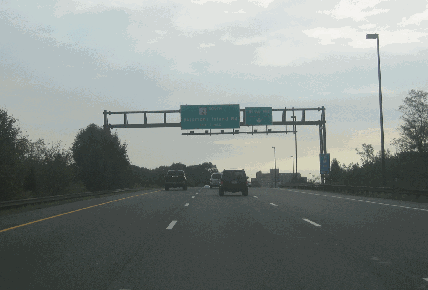
This 2005 photo shows the eastbound Aris T. Allen Boulevard (MD 665) at the Riva Road exit in Annapolis. This highway originally was planned to be part of the Patuxtent Freeway, other sections of which included today's MD 32 and I-97. (Photo by Steve Anderson.) |
||

|
A SPUR FROM ANNAPOLIS TO THE NORTH AND WEST: When the Maryland State Roads Commission (SRC) proposed the Patuxent Freeway (MD 32) in the 1960's, it planned to continue the route 3.9 miles south of US 50 / US 301 (John Hanson Highway) to Forest Drive in Annapolis. (At the time, MD 32 was to be routed along the southernmost seven miles of I-97.) The freeway spur was to provide a controlled-access link to downtown Annapolis from points north and west. |
||
|
The Patuxent Spur, which was referred as "Patuxent Boulevard" in the Annapolis city master plan, was planned as a four-lane freeway with adequate median right-of-way set aside for an additional two lanes in the future. Originally designated MD 32, the spur was to have a design capacity of 45,000 vehicles per day (AADT). A 1972 report by the State Highway Administration (SHA) - the agency succeeding the SRC - pegged the cost of the Patuxtent Freeway extension at $29 million. However, with spending priorities directed toward the completion of Maryland's Interstate highway network, the SHA shelved plans the Patuxent Spur and did not acquire any rights-of-way. |
||
|
As Interstate funds became available for I-97 and US 50 / US 301 (which was given the secret I-595 designation) in the 1980's, the SHA revived plans for the Patuxent Spur. The spur was to be built through a developed area, but its construction as planned would have cut a path through an established neighborhood. Aris T. Allen, a longtime doctor, delegate, and state senator who later became the first black chairman of the state Republican Party, influenced the SHA to realign the freeway's path further north along Forest Drive away from the threatened neighborhood. |
||

|
SOURCES: "Maryland 20-Year Highway Program (1977-1996)," Maryland State Highway Administration (1972); "Growth Plan Unveiled for Annapolis Peninsula" by Kaye Thompson, The Washington Post (6/26/1984); "State Embarking on Major Reforestation Along Route 50" by Margaret Camp, The Washington Post (9/06/1990); "Major Transportation Milestones in the Baltimore Region Since 1940," Baltimore Metropolitan Council (2006); "Unspoken Words: Dr. Aris T. Allen" by Ben Miller, Bay Weekly (1/18/2007); Scott Kozel; Mike Pruett; Alexander Svirsky. |
||
|
ARIS T. ALLEN BOULEVARD LINK: |
||
|
ARIS T. ALLEN BOULEVARD CURRENT CONDITIONS: |
||

|
OFF-SITE EXIT LISTINGS: |
||
|
VIEW OR SUBMIT YOUR RATINGS TO RATETHEROADS.COM: |
||

|
Back to The Roads of Metro Washington-Baltimore home page. |
||
|
Site contents © by Eastern Roads. This is not an official site run by a government agency. Recommendations provided on this site are strictly those of the author and contributors, not of any government or corporate entity. |
||