
|
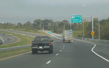
This 2005 photo shows the westbound Patuxent Freeway (MD 32) at EXIT 4 (MD 170 / Telegraph Road) in Odenton. Exit numbers were added to MD 32 in 2006. (Photo by Steve Anderson.) |
||

|
A DIRECT LINK BETWEEN I-70 AND THE STATE CAPITAL: As early as the 1950's, the Maryland State Roads Commission (SRC) advocated construction of a freeway connecting I-70 / UD 40 (Baltimore National Pike) in West Friendship with Fort Meade and Annapolis. This road, which soon became known as the Patuxent Freeway, was given the MD 32 designation, and as a state highway was to be financed under a 50-50 formula between the Federal and state governments. |
||
|
Between 1957 and 1960, the SRC built a nine-mile-long extension of Sykesville Road as a partially controlled-access MD 32 with the intention of upgrading this section in the distant future once the rural area through which it passed became more developed. This section of MD 32 was built with a single carriageway and accommodates only one lane in each direction; there also are several signalized intersections. The MD 32 designation then continued along Guilford Road to the main entrance to Fort Meade. |
||
|
|
||
|
Most of the 22.5 miles of the existing freeway accommodates four travel lanes (two in each direction); however, there are six travel lanes between EXIT 13 (I-95) and EXIT 16 (US 29) in Columbia. There is a wide variable grassy median averaging 54 feet in width to accommodate an additional travel lane in each direction in the future; this median widens at EXIT 13 for the left-hand exit ramps to I-95, and between EXIT 14 (Broken Land Parkway) and EXIT 15 (Eden Brook Drive) for a future quad-carriageway setup (in which new through-travel lanes would be in the current median while the existing roadways would become C/D roads). The one exception is the Fort Meade section where the two carriageways are separated only by a concrete "Jersey" barrier. According to the Maryland State Highway Administration (SHA), the Patuxent Freeway carries approximately 70,000 vehicles per day (AADT) from I-97 west to MD 295 and as much as 100,000 per day from MD 295 west to US 29. Traffic volumes fall off significantly west of US 29 to roughly 40,000 vehicles per day near MD 108. CHANGES FOR AN INTERCHANGE: In June 2008, the SHA announced plans to rebuild EXIT 8 (MD 198 / Laurel-Fort Meade Road) in anticipation of the proposed widening of MD 198 to four lanes (from two) to serve Fort Meade. The SHA offered five alternatives, which would entail either modifying or eliminating the two existing roundabouts abutting the MD 198 overpass (which would be widened) altogether:
Construction of the MD 198 widening and interchange project is expected to cost as much as $185 million; it is scheduled to begin in 2011. |
||
|
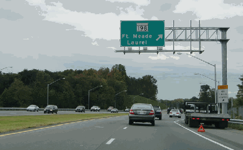
This 2004 photo shows the westbound Patuxent Freeway (MD 32) at EXIT 8 (MD 198 / Laurel-Fort Meade Road) in Fort Meade. Work on this section of MD 32 -- including utility relocation -- was completed one year later. The SHA plans a massive reconstruction of this interchange in conjunction with the widening of MD 198 beginning in 2011. (Photo by Alex Nitzman, aaroads.com.) |
||

|
AFTER DECADES OF DELAY, SOME ACTION: Even as traffic on MD 32 through Howard County had grown seven-fold between 1980 and 2003, and even though the state had set aside right-of-way for an eventual expansion, state officials maintained a hands-off approach to converting MD 32 into a freeway based on "smart growth" initiatives espoused by Governor Parris Glendening in the 1990's. |
||
|
In 2004, Governor Robert Ehrlich, acting on his mandate to relieve congestion on the state's highways, advanced plans to build the remaining nine miles of the Patuxent Freeway, which was estimated to cost $200 million to complete. New interchanges are planned at the following locations: |
||


|
AN INTERSTATE CONNECTION FROM I-70 TO ANNAPOLIS: Upon final completion, the entire length of the Patuxent Freeway from John Hanson Highway (I-595 / US 50 / US 301) northwest to I-70 should be re-designated I-297. The existing "southeast leg" of I-97 would shift west to the existing MD 3 / US 301 alignment for an extended I-97 toward Virginia. |
||

|
SOURCES: "20-Year Highway Needs Study," Maryland State Roads Commission (1968); "State Primary Highway System," Maryland Department of Transportation (1972); "MD 32 (Patuxent Freeway), Anne Arundel and Howard Counties: Environmental Impact Statement," Federal Highway Administration and Maryland Department of Transportation (1977); "MD 32 (Patuxent Freeway) Construction from MD 32 to MD 3: Environmental Impact Statement," Federal Highway Administration and Maryland Department of Transportation (1983); "Dr. Gridlock" by Ron Shaffer, The Washington Post (5/30/2002); "State Is Planning To Widen 9-Mile Stretch of Route 32," The Baltimore Sun (7/13/2004); Maryland Route 32: A Policy Analysis, University of Maryland-Baltimore County (2004); "New Ramps To Open at the MD 32 / Canine Road Interchange in Anne Arundel County," Maryland State Highway Administration (1/14/2005); "MD 32 (Patuxent Freeway) Construction from MD 108 to I-70: Final Environmental Impact Statement," Federal Highway Administration and Maryland Department of Transportation (2005); "New Routes 198 and 32 Interchange Being Considered" by Joshua Stewart, The Annapolis Capital (6/25/2008); Scott Kozel; Mike Pruett; Alexander Svirsky. |
||
|
PATUXTENT FREEWAY LINKS: |
||
|
PATUXENT FREEWAY CURRENT CONDITIONS: |
||

|
OFF-SITE EXIT LISTINGS: |
||
|
VIEW OR SUBMIT YOUR RATINGS TO RATETHEROADS.COM: |
||

|
Back to The Roads of Metro Washington-Baltimore home page. |
||
|
Site contents © by Eastern Roads. This is not an official site run by a government agency. Recommendations provided on this site are strictly those of the author and contributors, not of any government or corporate entity. |
||