
|
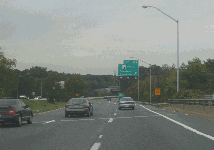
This 2005 photo shows the westbound Paul T. Pitcher Memorial Highway (MD 100) westbound at EXIT 16 (MD 2 / Ritchie Highway) in Pasadena. (Photo by Steve Anderson.) |
||

|
As early as 1955, the Maryland State Roads Commission (SRC) designed plans for an outer beltway to supplement the Baltimore Beltway (I-695) then under construction. What eventually became MD 100 was the southern arc of the proposed outer beltway. In anticipation of significant population growth between Baltimore and Washington, the SRC decided to build the southern arc of the outer beltway first as a link between US 29 (Columbia Pike) in Ellicott City and MD 177 (Mountain Road) in Pasadena. The 1964 Baltimore Metropolitan Area Transportation Study proposed the route as the "Dorsey Freeway" as it was to relieve congestion on MD 176 (Dorsey Road) through Anne Arundel County. |
||
|
THE MOUNTAIN ROAD BYPASS: Work began on the first section of MD 100 in 1963. The 3.7-mile-long section originally was called the "Mountain Road Freeway" because it connected Mountain Road with the Glen Burnie Bypass (now I-97). Indeed, this section initially had the MD 177 designation because it was an extension of Mountain Road. The short section of four-lane freeway was completed in 1965 at a cost of $2.4 million. |
||
|
|
||
|
Despite the $55 million allocated for the completion of MD 100 (according to the 1972 statewide highway plan), most state highway funds during the 1970s were diverted to the completion of Maryland's Interstate highway network - particularly within Baltimore city limits. Given increasing budget restraints and a growing shift among officials to favor mass transit projects, the state shelved plans to extend MD 100 west of I-95 in 1974. |
||

|
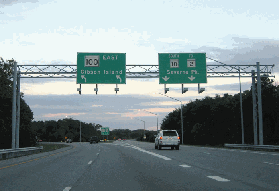
These 2005 photos shows the eastbound Paul T. Pitcher Memorial Highway (MD 100) eastbound at EXIT 8 (Coca-Cola Drive) in Hanover and EXIT 18 (MD 10 / Arundel Expressway) in Pasadena. (Photos by Alex Nitzman, www.aaroads.com.) |
||
|
REVIVING MD 100 WEST OF I-95: By the end of the 1970s, the Baltimore Outer Beltway had been dead for several years, but officials in Anne Arundel and Howard counties persuaded the state to revive plans to extend MD 100 to serve rapidly developing communities in the Baltimore-Washington corridor. The missing links of MD 100 were added back to state plans in 1979. |
||
|
One key figure in reviving MD 100 plans was Elizabeth Bobo, who as citizen activist fought plans to extend MD 100, but as Howard County Executive in the 1980s supported construction of the freeway to relieve congestion. Another key figure was Valerie McGuire, an Ellicott City day care provider who--on her kitchen table--developed the "S" alignment that saved a number of townhouses in the Hunt Country Estates development. |
||
|
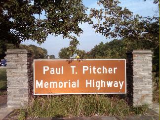
This 2010 photo shows a commemorative sign marking the beginning of the westbound "Paul T. Pitcher Memorial Highway" in Pasadena. The photo was taken by the grandson of the former county commissioner and circuit court judge. (Photo by Paul T. Pitcher.) |
||

|
PLANNING AN OUTER BELTWAY: With work well underway on the Baltimore Beltway (I-695) and the Capital Beltway (I-495) in the late 1950s, officials at the Maryland State Roads Commission already were planning for the distant future. To accommodate traffic growth years in advance, the SRC planned outer beltways for Baltimore and Washington. |
||
|
The 1968 statewide highway plan mapped out the following 54.3-mile-long route for the unbuilt section of the Baltimore Outer Beltway from MD 99 (Old Frederick Road) in Ellicott City to I-695 (Baltimore Beltway) in Dundalk: |
||

|
BUILD A NEW EXIT 21: The existing signalized intersection at MD 607 (Magothy Bridge Road) should be replaced with a grade-separated, partial-cloverleaf interchange. Just east of the new EXIT 21, an overpass should be built to carry Magothy Beach Road over MD 100. |
||

|
SOURCES: "Map of Future Expressway System," The Baltimore Sun (12/14/1955); "New DC Road Is Planned," The Baltimore Sun (11/28/1961); "Glen Burnie's Bypass Open," The Baltimore Sun (5/28/1965); "Freeway Eases Traffic Through Glen Burnie" by Lawrence McDaniel, The Baltimore Sun (7/09/1965); "20-Year Highway Needs Study," Maryland State Roads Commission (1968); "State Primary Highway System," Maryland Department of Transportation (1972); "State Plans New Route 100 Extension," The Baltimore Sun (3/01/1979); "County Officials To Decide on Route 100 Plan" by Molly Sinclair, The Washington Post (7/22/1993); "Final Leg of Route 100 Opens in Howard, Connector Links Route 29 and I-95" by Craig Whitlock, The Washington Post (11/26/1998); "Maryland 100," Asphalt Paver-Maryland Asphalt Association (Spring-Summer 1999); Alex Nitzman; Paul Pitcher; Mike Pruett. |
||
|
PAUL T. PITCHER MEMORIAL HIGHWAY LINKS: |
||
|
PAUL T. PITCHER MEMORIAL HIGHWAY CURRENT CONDITIONS: |
||

|
OFF-SITE EXIT LISTINGS: |
||
|
VIEW OR SUBMIT YOUR RATINGS TO RATETHEROADS.COM: |
||
|
Back to The Roads of Metro Washington-Baltimore home page. |
||
|
Site contents © by Eastern Roads. This is not an official site run by a government agency. Recommendations provided on this site are strictly those of the author and contributors, not of any government or corporate entity. |
||