
|
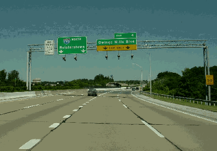
This 2002 photo shows the northbound Northwest Expressway (I-795) at EXIT 4 (Owings Mills Boulevard) in Owings Mills. Engineers set aside the center median for the Baltimore Metro extension to Owings Mills, which was completed in 1987, two years after this section of I-795 was completed. (Photo by Jim K. Georges.) |
||

|
FOUR DECADES FROM DRAWING BOARD TO REALITY: Plans for the Northwest Expressway date back to at least 1947 when Governor William Preston Lane, Jr. announced the "Maryland Highway Program" that envisioned new freeways to replace US 140, US 111, US 40, and US 1 out of Baltimore City. The freeway to parallel US 1--the Baltimore-Washington Parkway (MD 295)--was first, and the US 40 and US 111 routes were incorporated into state plans for the Interstate highway system a decade later as I-95, I-70, and I-83. Without Interstate funds to secure construction plans, construction of the "Northwest" route to Reistertown--then designated US 140--would be delayed for decades to come. |
||
|
The denial of Interstate funding did not stop the Maryland State Roads Commission (SRC) from purchasing rights-of-way along the route, and the SRC even built stub ramps on the Baltimore Beltway (I-695) as part of the original 1961 construction for a future cloverleaf interchange with the Northwest Expressway at the site of the current EXIT 19 on I-695. In the vicinity of the current EXIT 7 (Franklin Boulevard) on I-795, there was to have been an interchange with the proposed but unbuilt Baltimore Outer Loop (MD 100 / US 29). However, controversy over the route south of the beltway--particularly in the historic planned community of Sudbrook Park--added to the delays. |
||
|
The "inside the beltway" section of the Northwest Expressway was canceled in 1973, but plans remained active for the expressway between I-695 and Reisterstown. The Baltimore Metro transit line was to be built along four of the expressway's nine miles to Owings Mills, and in recognition of the proposed Metro line terminus, officials in Baltimore County named Owings Mills as a designated area for commercial and light industrial growth in the county's 1979 master plan. Perhaps in recognition of Owings Mills' status as a selected growth area, the Northwest Expressway shed its now-decommissioned US 140 designation and became the future I-795 in 1980. Funding for I-795 would come eventually from other highway projects canceled throughout the state, particularly the unbuilt highways in Baltimore City. |
||
|
ON THE FAST TRACK: Ground was broken for the Northwest Expressway in 1982. The initial six-lane section from the southern terminus at EXIT 1 (I-695) in Pikesville north to EXIT 4 (Owings Mills Boulevard) in Owings Mills opened to traffic in November 1985; it featured a concrete surface and a wide median to accommodate construction of the Baltimore Metro and the Owings Mills Station. The northbound EXIT 4 ramp splits into two for the northbound and southbound lanes of Owings Mills Boulevard, while a C/D road and two separate exit ramps were built for traffic from southbound I-795. |
||
|
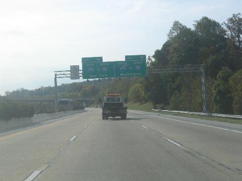
This 2005 photo shows the southbound Northwest Expressway (I-695) approaching its southern terminus at EXIT 1 (I-695 / Baltimore Beltway). Original plans from the early 1970's called for widening I-795 to eight lanes, but current traffic counts appear not to warrant such an expansion. (Photo by Steve Anderson.) |
||

|
INSIDE THE BELTWAY: South of I-695, the Northwest Expressway was to retain the six-lane profile of the section that actually was built, including a wide median for a two-track rapid transit line. Inside the city line, the Northwest Expressway was to have been routed along the current Metro line and Wabash Avenue, terminating at Reisterstown Road (old US 140 and current MD 140) just south of the Metro-West Coldspring Station. One planning map suggested the Northwest Expressway would have terminated at a proposed Cold Spring-Moravia (Loop) Freeway (undesignated). |
||
|
No cost estimate was provided for the Northwest Expressway within Baltimore City, but given the rising costs of the 10-D Interstate construction program and even the less aggressive 3-A plan, the Maryland State Highway Administration (SHA) focused on completion of the most essential elements of the plan--completing I-95, extending I-83, and building I-395--while shifting some unused highway funds toward Metro construction. |
||

|
SOURCES: Interstate Highways 70N and 95, the East-West and Southwest Expressways, Preliminary Engineering Report, City of Baltimore Department of Public Works (1961); "Maryland Plans Six More Toll Roads," The Washington Post (2/08/1968); "Greater Baltimore Committee: Traffic Evaluation Summary," Urban Design Concept Associates (1968); "US 140 (Northwest Expressway), Baltimore City Line to Reisterstown and Phase 1 Rapid Transit: Final Environmental Impact Statement," Federal Highway Administration and Maryland State Highway Administration (1977); "The Other Metro" by Stephen J. Lynton, The Washington Post (10/30/1983); "Mayor Reconsiders Extension of I-795," The Baltimore Sun (2/25/1993); "Finksburg Residents Thrash Dell's I-795 Plan" by Kerry O'Rourke, The Baltimore Sun (4/08/1993); "Baltimore County Asks for New Interchange on Interstate 795" by Jay Apperson, The Baltimore Sun (7/29/1998); "Carroll Commissioner Revives Plan To Extend I-795 To Ease Congestion" by Sheridan Lyons, The Baltimore Sun (9/18/1998); "Bridge Reopening Another Chapter of Sudbrook Story" by Melanie Anson, Owings Mills Times (10/19/2006); "Major Transportation Milestones in the Baltimore Region Since 1940," Baltimore Metropolitan Council (2006); "Feasibility Study: Interchange of I-795 With Pleasant Hill Road (Future Dolfield Boulevard)," Maryland State Highway Administration (2006); "Highway Planning Begins" by Lind Strowbridge, Owings Mills Times (1/04/2008); HistoricAerials.com; Sudbrook Park, Inc.; Robert V. Droz; Adam Froehlig; Scott Kozel; Mike Pruett; Alexander Svirsky. |
||

|
NORTHWEST EXPRESSWAY LINKS: |
||
|
NORTHWEST EXPRESSWAY CURRENT CONDITIONS: |
||

|
THE EXITS OF WASHINGTON-BALTIMORE: |
||
|
VIEW OR SUBMIT YOUR RATING TO RATETHEROADS.COM: |
||
|
Back to The Roads of Metro Washington-Baltimore home page. |
||
|
Site contents © by Eastern Roads. This is not an official site run by a government agency. Recommendations provided on this site are strictly those of the author and contributors, not of any government or corporate entity. |
||