
|
|
||
|
This 2005 photo shows the westbound I-70 approaching EXIT 91 (I-695 / Baltimore Beltway) in Woodlawn, just west of the Baltimore City line. (Photo by Steve Anderson.) |
||
|
Length: |
||
|
93.6 miles (150.7 kilometers) |
||

|
THE BALTIMORE NATIONAL PIKE: The I-70 of today had its origins in the immediate postwar years as a four-lane divided relocation and reconstruction of US 40. Work on building the new US 40 began in 1949 with a roughly 29-mile stretch of four-lane highway from Patrick Street in Frederick east to Pine Orchard (Ellicott City). Over the next seven years, US 40 was upgraded from a two-lane road to a four-lane divided arterial highway. Grade-separated interchanges were built at MD 27 (current EXIT 68), MD 97 (current EXIT 76), and MD 32 (current EXIT 80). The four-lane Baltimore National Pike was completed in 1956 with the opening of the new Jug Bridge, which paralleled the existing Jug Bridge (built in 1944) over the Monocacy River. |
||
|
THE FREDERICK FREEWAY: Work on the first modern freeway section of what would become I-70 began in 1954. The Frederick Freeway was designed as a bypass of Patrick Street, which was the former alignment of US 40 through downtown Frederick. The original freeway ran west from East Patrick Street (current EXIT 56), then veered north at the Washington National Pike (current EXIT 53 / I-270) and continued north to West Patrick Street (current EXIT 13 on US 15 / Frederick Freeway). This original section of freeway was completed in 1959. The section from East Patrick Street to the Washington National Pike initially was signed as US 40, eventually was signed as I-70N, though the signing as I-70N did not happen for several years. |
||
|
|
||
|
FROM FREDERICK TO BALTIMORE: With I-70 nearing completion west of Frederick in the late 1960s, the state turned its attention to completing the freeway--which was then called I-70N--east to Baltimore. This construction, a description of which follows, was not completed until the mid-1980s. |
||
|
This 2004 photo shows the westbound I-70 at EXIT 26 (I-81) in Hagerstown. At this interchange, a pair of collector-distributor (C/D) roads serve the ramps connecting to and from I-81. Conversely, a pair of C/D roads along I-81 serve the ramps connecting to and from I-70. (Photo by Jim K. Georges.) |
||


|
A NEW NAME EAST OF FREDERICK: On May 18, 1975, the American Association of State Highway and Transportation Officials (AASHTO) approved the change of the I-70N designation from Frederick east to Baltimore to I-70, although the Maryland SHA began promoting this change on highway signs months earlier. At the same time, the I-70S designation from Frederick southeast into Montgomery County became I-270. |
||
|
REBUILDING THROUGH FREDERICK: In 1984, the Maryland SHA published a comprehensive study on widening the roadway and improving safety along I-70. The focus of this study covered I-70 from the Mount Philip Road overpass (just east of milepost 50) east to East Patrick Street (MD 144), the current location of EXIT 56 and east of where construction on new alignment was well underway. The primary focus of the study was the original stretch of the Frederick Freeway from EXIT 53 (I-270 SOUTH and US 15 NORTH) east to EXIT 56 (MD 144 / East Patrick Street), which was built in the early days of the Interstate highway system and thus suffered from deficiencies such as inadequate mainline capacity, substandard acceleration and deceleration lanes, tight curve radii, and missing interchange movements. |
||
|
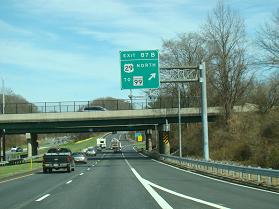
These 2017 photos show the eastbound I-70 at EXIT 82 (US 40 / Baltimore National Pike) and EXIT 87 (US 29 / Columbia Pike). (Photos by David Golub, www.eastcoastroads.com.) |
||
|
According to the Maryland SHA, I-70 carries the following approximate traffic counts per day (AADT): |
||
|
FUTURE PLANS TO WIDEN WEST, AND NARROW EAST, OF THE BELTWAY: In the early 2010s, the Baltimore Regional Transportation Board recommended widening the remaining four-lane section of I-70 between EXIT 82 and EXIT 87 in Ellicott City to six lanes. The report also recommended adding the missing interchange movements at EXIT 83 (Marriottsville Road): a new exit ramp from eastbound I-70, and a new entrance ramp to westbound I-70. |
||
|
LEFT: This 2017 photo shows the westbound I-70 just west of EXIT 91 (I-695 / Baltimore Beltway). The Maryland SHA posted this sign to show the distances to select major cities along I-70, as well as to the western terminus of I-70 in Cove Fort, UT. RIGHT: This 2017 photo shows the eastbound I-70 approaching EXIT 91. This sign shows the revised official eastern end of I-70 at I-695 per AASHTO, though the I-70 freeway actually continues three miles east to EXIT 94 (MD 122 / Security Boulevard.) (Photos by David Golub, www.eastcoastroads.com.) |
||

|
EARLY PLANNING FOR BALTIMORE'S EXPRESSWAYS: In 1942, with the U.S. involvement in World War II well underway, officials in Baltimore developed plans for an express bypass of the city. The city proposed two separate routes: a tunnel under Franklin Street (which later became US 40 / Franklin-Mulberry Expressway) and an elevated expressway above Pratt Street. Both routes were to have an east-west orientation. The Baltimore City Planning Commission (BCPC) approved this plan in 1943, though this decision was non-binding. |
||
|
The following year, Robert Moses, who was the master planner for New York's arterial highway system, was hired as a consultant by the BCPC to develop its plans further. Although the plans contemplated parkway-like design treatment for the proposed East-West (Pratt) Expressway and the Franklin (Mulberry) Expressway, and Moses defended his designs by stating they would help defeat urban blight, the BCPC ultimately rejected Moses' plans. |
||
|
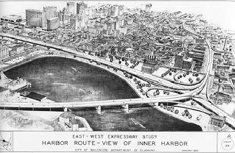
This 1957 map shows proposed routings for the East-West Expressway, which includes (1) a preferred routing along the edge of the Inner Harbor; (2) a southern alternate routing that was the basis of what later became the "Fort McHenry" alignment of today's I-95; (3) a northern alternate routing that would have taken I-95 north of downtown Baltimore and continued straight west as I-70N; and (4) an inner loop freeway encircling downtown Baltimore. The Jones Falls Expressway (I-83), which was to enter the city from the north, was included in all alternatives. (Map from City of Baltimore-Department of Planning archives.) |
||
|
BALTIMORE'S RESPONSE TO THE INTERSTATE SYSTEM� THE 10-D PLAN: In 1958, Baltimore mayor Thomas D'Alesandro, Jr. named Phillip Darling of the city's planning department. Darling saw the threat posed by the construction of the Baltimore Beltway (I-695) in luring business out of the city, and thought it was necessary that the city respond by building radial expressways to not only address the needs of commuters and shippers, but also help the city retain and attract business. |
||
|
After two years of study, Darling published the report, "A Study for an East-West Expressway," in 1960. The Darling plan maintained the same radial axes as the Smith Report from 15 years earlier, but there were key changes to the plan that represented an initial attempt to balance the needs of the business community with those of residents. All three radial expressways were to have been eight lanes wide. |
||
|
|
||


|
|
||

|
|
||
|
The 10-D "harbor route" alignment was preferred over the north-of-downtown alignment proposed in 1957, as it would have required the removal of 3,187 dwelling units, four business buildings, and no churches for the 10-D alignment, versus 5,582 dwelling units, 18 business buildings, and six churches for the northerly alignment. The cost difference between the 10-D and northerly alternatives was nominal; the estimated cost was about $225 million for the 10-D alignment, versus $194 million for the northerly alignment. |
||
|
This map shows the original 10-D expressway plan devised by the Baltimore City Department of Planning. Note how I-95, I-70N, and I-83 were to converge at a major interchange at the northeast corner of the Inner Harbor. (Map from City of Baltimore-Department of Planning Archives.) |
||
|
This illustration shows the major interchange between I-95, I-70N, and I-83 that was proposed for the northeast corner of the Inner Harbor under the original 10-D plan. View is toward the northwest. (Map from City of Baltimore-Department of Planning Archives.) |
||
|
AN INITIAL ALTERNATIVE TO 10-D: The city hired a locally-based consortium called Expressway Consultants to review Darling's 10-D proposal. The consortium was comprised of J.E. Greiner Company, which worked on the Baltimore Harbor Tunnel and the William Preston Lane Jr.-Chesapeake Bay Bridge; Remmel, Klepper & Kahl, which worked on the Baltimore Beltway, and Knoerle, Graef, Bender & Asssociates, which worked on the Jones Falls Expressway. |
||
|
The key differences between the Expressway Consultants plan and Darling's 10-D plan were as follows: |
||
|
This map shows Expressway Consultants' response to the 10-D plan devised by the Baltimore City Planning Department. Under this plan, I-95 would have avoided downtown Baltimore, while there would have been separate interchanges with I-70N (East-West Expressway) and I-83 (Jones Falls Expressway). (Map from City of Baltimore-Department of Planning Archives.) |
||
|
This illustration shows the major interchange between I-95 and I-83 that was proposed for the eastern edge of the Inner Harbor under the Expressway Consultants alternative. View is toward the northwest. (Map from City of Baltimore-Department of Planning Archives.) |
||
|
COLLABORATING FOR A BETTER SOLUTION: In response to concerns expressed by pro-expressway groups and community advocates, the City of Baltimore and the Bureau of Public Roads (later the Federal Highway Administration [FHWA]) collaborated on a new technique of highway planning which included participation by the public in the planning stages of a project and consideration of public comments for proposed plans. This technique is commonplace in modern highway planning, but was a novel concept in the 1960s. |
||
|
What emerged from this collaboration was the Urban Design Concept Associates (UDCA), known internally as the "Concept Team," which was formed in 1966 from Expressway Consultants (which had worked earlier on an alternative to the 10-D plan), two technical consulting firms (Parsons, Brinckeroff, Quade & Douglas and Wilbur Smith & Associates), architects from Skidmore Owings & Merrill, and other experts. In early 1969, the UDCA published their reasoning for developing a new highway plan as follows: |
||

|
This map shows the final routing for I-70N (East-West Expressway) as proposed under the 1969 3-A expressway plan. Under this plan, I-70N was to have entered Baltimore from the west through Leakin Park, then turned south through Gwynns Falls Park before ending at I-95. An interchange was to have been built for I-170 (Franklin-Mulberry Expressway). I-70N was redesignated I-70 in 1975. I-70 was canceled northwest of I-170 in 1981, and southeast of I-170 in 1983. (Map from City of Baltimore-Department of Planning Archives.) |
||
|
THE BATTLE OF LEAKIN AND GWYNNS FALLS PARKS: The right-of-way for I-70N was estimated to take about 150 of the 1,200 acres in both parks, and this itself posed a challenge, as legislation passed in 1966--the so-called "Section 4(f)" law--prohibited any Federal government agencies from using land from public parks, recreation areas, wildlife refuges, and historic properties unless there was no "feasible and prudent" alternative. With this in mind, the UDCA, in conjunction with I-70N construction, planned to improve both parks with the construction of three swimming pools, 27 new miles of trails, tennis courts, baseball fields, picnic areas, and a daycare center. In planning I-70N through Leakin and Gwynns Falls Parks, the UDCA team went a step further by proposing that the Federal government pay for 90 percent of the cost of improving both parks, which was the same percentage that the Federal government paid for Interstate highway construction. These improvements would have added to the estimated $141 million cost just for completing I-70N. |
||
|
Despite the UDCA's planned park improvements, conservationists fought vigorously to stop the 4.8-mile-long I-70N extension. In 1971, the Sierra Club joined with several local conservationist groups to stop construction of the eight-lane freeway, citing the potential for incremental pollution and blight. On March 15, 1972, Baltimore Circuit Court Judge Meyer Cardin ruled that the city had the right to use parkland for I-70N, though added that a more workable solution would be what the UDCA team proposed: having the Federal government compensate the city for building not only I-70N, but also associated park improvements. This ruling was overruled on June 8, 1972, when US District Court Judge James Miller, Jr. ordered a stop to construction until new environmental studies were undertaken, and additional public hearings were held. (Before one of the public hearings held in December 1972, one of the opponents of the I-70N project was shot and killed in a robbery attempt in front of the hearing site at Edmondson High School.) |
||
|
This 2010 photo shows the eastern terminus of I-70 at the park-and-ride lot looking west toward EXIT 94 (Security Boulevard and Cooks Lane) and the start of westbound I-70. The freeway was stopped east of this point in 1981. This point now serves as a trailhead for the 15-mile-long Gwynns Falls Trail. (Photo by Steve Anderson.) |
||
|
AFTER I-70 EXTENSION CANCELED, A LAST-DITCH EFFORT TO EXTEND I-170: In light of the growing unpopularity of the proposed I-70 extension through Leakin Park, as well as the lack of politically viable alternate alignments, Governor Harry Hughes and Mayor Schaefer requested withdrawal of I-70 east of Security Boulevard on July 28, 1981. The Federal Highway Administration (FHWA) approved this request on September 3, 1981. |
||
|
With I-70 canceled, the city and state went forward with an alternative proposal that would extend the I-170 extension to Gwynns Falls, then extend the route south to I-95 via the remaining 2.2-mile-long former alignment of I-70 that had not been canceled. This former I-70 alignment, as well as the existing and proposed sections of I-170, was to assume a new designation: I-595. Although the American Association of State Highway and Transportation Officials (AASHTO) approved the new designation in November 1982, no I-595 signs ever appeared on the completed section of I-170. |
||


|
In January 1983, the city's Interstate highway division submitted a draft environment impact statement for the proposed I-595. The report presented three different freeway alternative, with a fourth alternative designed as a connecting boulevard. All of the alternatives would have assumed the I-70 / I-170 right-of-way, as well as a directional-T interchange with I-95. However, the freeway alternatives featured a grade-separated diamond interchange with US 1 (Wilkens Avenue) and MD 144 (Frederick Avenue), as well as a new connection to an extended Hilton Parkway. Cost estimates ranged from $140 million for the boulevard to $200 million for the most expensive freeway alternative, though only the freeway alternatives offered 90 percent Federal reimbursement for the cost. |
||
|
This 1983 map shows the final incarnation of I-70 as a stub route, I-595, connecting I-95 with the already completed I-170 (now US 40). I-595 through Lower Gwynns Falls was canceled toward the end of 1983. (Map © 1983 by H.M. Gousha Company.) |
||

|
WIDENING FOR A LESS CONGESTED I-70: I-70 should be widened to a continuous six lanes--three in each direction--from EXIT 24 (MD 63) in Williamsport east to EXIT 53 (I-270) in Frederick. It also should be widened to a continuous eight lanes--four in each direction--from EXIT 80 (MD 32 / Future Patuxent Freeway Extension) in West Friendship east to EXIT 91 (I-695 / Baltimore Beltway) in Woodlawn. The proposed I-70 / I-695 interchange reconstruction should take potential future widening of not only I-695, but also I-70 into consideration. |
||

|
SOURCES: "Expressway Pool Plan Announced" by Louis O'Donnell, The Baltimore Sun (3/17/1945); "Plans To Push Expressway," The Baltimore Sun (8/07/1947); "Expressway Leg Protest Is Seen," The Baltimore Sun (4/02/1965); "Route Is Set on East-West Expressway," The Baltimore Sun (10/19/1968); "Group Supports Road Route Rejected by Design Team," The Baltimore Sun (12/08/1968); "Mayor's Route Choice Averts Harbor Span, Bypasses Rosemont" by John B. O'Donnell, Jr., The Baltimore Sun (12/24/1968); Transportation, Environmental, and Cost Summary: An Evaluation of Three Concepts for Expressway Routes in Baltimore City, Urban Design Concept Associates (1968); "City's 3-A Route Wins Approval of US Agency" by John B. O'Donnell, Jr., The Baltimore Sun (1/18/1969); "Three New East-West Routes Studied" by Kathy Kraus, The Baltimore Sun (5/20/1970); "Park Improvement Is Proposed," The Baltimore Sun (7/16/1970); "New Boulevard Proposed for Downtown," The Baltimore Sun (8/10/1970); "Conservationists Sue To Keep I-70 Out of Leakin, Gwynns Falls Parks," The Baltimore Sun (10/13/1971); "Baltimore Interstate Highway System 3-A: Facts and Features," Urban Design Concept Associates (1971); "Judge Blocks Park Route for Road, Orders Hearings" by James D. Dilts, The Baltimore Sun (6/09/1972); "Father of 13 Dies; Was Shot on Way to Expressway Parley," The Baltimore Sun (1/07/1973); "Park Unit Bars I-70 Plan Shift," The Baltimore Sun (1/25/1973); "Debate and Discussion: Leakin Park, a Disputed Highway Route" by Douglas S. Tanwey and George L. Sheper, The Baltimore Sun (2/07/1976); "Leakin Park Expressway Plans To Be Revived," The Baltimore Sun (3/05/1977); "Mayor Backs Road Plans, but Voices Doubts on I-70" by Antero Pietila, The Baltimore Sun (12/08/1979); "I-70 Plans Lose GBC's Results" by Antero Pietila, The Baltimore Sun (3/11/1980); "Funds Short for Leakin, I-83 Routes" by Antero Pietila, The Baltimore Sun (5/06/1980); "Mayor Seeks To Divert I-70 Plans" by Eileen Canzian, The Baltimore Sun (3/20/1981); "$200 Million for I-70 May Go to Subway Line" by Tom Linthicum, The Baltimore Sun (9/05/1981); "City Weighing Gwynns Falls Interstate Plan" by David Brown, The Baltimore Sun (1/23/1983); Transportation Improvements in the Interstate 595 Corridor from I-95 to I-170: Draft Environmental Impact Statement, Federal Highway Administration, Maryland Department of Transportation-State Highway Administration, and Interstate Division for Baltimore City (1983); "Plan Would Lop Off Eastern Stub of Interstate 70" by Michael Dresser, The Baltimore Sun (10/11/2011); "Transportation Outlook 2035: Creating a Blueprint for Baltimore's Future," Baltimore Regional Transportation Board (2013); "Maryland Designates $461 Million To Ease Traffic Jams on Baltimore Beltway" by Justin Rice, Mid-Atlantic Construction News (12/20/2017); Maryland Department of Transportation; Scott Kozel; Alex Nitzman; Mike Pruett; Douglas A. Willinger. |
||
|
INTERSTATE 70-MARYLAND LINKS: |
||
|
INTERSTATE 70-MARYLAND CURRENT TRAFFIC CONDITIONS: |
||
|
INTERSTATE 70-MARYLAND VIDEO LINKS: |
||

|
THE EXITS OF METRO WASHINGTON-BALTIMORE: |
||

|
Back to The Roads of Metro Washington-Baltimore home page. |
||
|
Site contents © by Eastern Roads. This is not an official site run by a government agency. Recommendations provided on this site are strictly those of the author and contributors, not of any government or corporate entity. |
||