
|
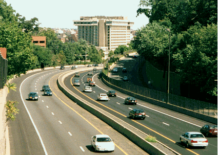
This 2000 photo shows Interstate 66 (Custis Memorial Parkway) looking east from the Scott Street overpass in Arlington. In the center of the photo is the Key Bridge Marriott, the oldest surviving original hotel in the Marriott chain. (Photo by Nick Klissas.) |
||
|
FROM THE POTOMAC TO THE BLUE RIDGE MOUNTAINS: As early as 1941, the route of what is known today as I-66 was included in the War Department's strategic network of interregional highways. During the war years and in the immediate postwar era, the general routing of I-66 from today's I-81 east to Washington was maintained in every proposed system map. The Federal Bureau of Public Roads (BPR) approved the basic routing of I-66 in 1956 as part of the Interstate highway system. |
||
|
In the initial planning stages, I-66 was planned with six lanes from I-81 east to the Fairfax County line, and eight lanes east through Fairfax and Arlington counties; however, I-66 was built initially with four lanes from I-81 east to US 50 and six lanes from US 50 to I-495 (Capital Beltway). By the middle of 1958, most of the route from I-81 east to VA 123 in Fairfax had been mapped out, but the final route from Fairfax to the Potomac River was the subject of controversy. The Virginia Highway Department (VHD) considered four separate alignments through Fairfax and Arlington counties: |
||
|
Early in the planning stages, it had been planned to cross the Potomac over a new span at Arizona Avenue, though the VDH dismissed this alternative as being too disruptive to communities and not providing adequate access to the proposed freeway system in the District of Columbia. The Arizona Avenue Bridge alternative also generated its own controversy on the District side of the Potomac, particularly as it was to connect to the Northwest Freeway (unbuilt I-70S / I-270). |
||
|
CONSTRUCTION WEST OF THE BELTWAY: Although the section of I-66 east of the Capital Beltway arguably was the most controversial of any Interstate highway built in Virginia, it also took a long time to build I-66 west of the Beltway. By 1975, less than half of I-66 through the state had been built as follows: |
||
|
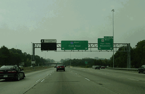
This 2004 photo shows the westbound I-66 at EXIT 57 (US 50 / Lee Jackson Memorial Highway) in Fairfax. (Photo by Laura Siggia Anderson.) |
||
|
CONTROVESY INSIDE THE BELTWAY: In the decade following the approval of I-66 east of the Capital Beltway, the VHD had acquired 94% of dwellings and 84% of the right-of-way from Falls Church east to Rosslyn, and nearly 500 families had been relocated. However, the state delayed construction because of (1) the passage of new laws in 1966 (the "Section 4(f)" legislation restricting highway construction through parkland) and 1970 (requiring extensive environmental impact statements); (2) negotiations over continued passenger rail operations on the Washington and Old Dominion Railroad, on whose right-of-way I-66 was to traverse; and (2) a protracted fight over not only the construction of I-66, but the location of its companion route, the I-266 / Three Sisters Bridge spur to Washington. |
||
|
Design hearings were underway in 1970, and in January 1971, the VDH reaffirmed the original eight-lane design for I-66. With construction imminent, opposition groups formed, the most notable of which was the Arlington Coalition on Transportation (ACT), which sought to replace I-66 with a Metro extension along the right-of-way per the Washington Metropolitan Area Transportation Authority's (WMATA) plan for the line adopted in 1968. ACT, along with a coalition of other groups and individuals, filed suit in US District Court to halt all future right-of-way acquisitions and construction, stating that plans for I-66 did not comply with Section 4(f) guidelines as its construction would require the taking of 15.5 acres of parkland. The US District Court rejected the suit in October 1971, but in April 1972, the US Fourth Circuit Court of Appeals reversed the lower court decision. The Fourth Circuit ruling prohibited further right-of-way acquisition and construction unless it filed an environmental impact statement and found no reasonable alternative subject to Section 4(f) guidelines. |
||
|
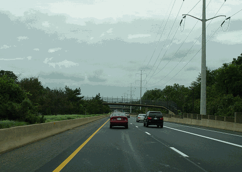
This 2004 photo shows the eastbound I-66 near milepost 70 in Arlington. Sharing the center landscaped median are the two tracks of the Metro-Vienna line, and on the right is a multi-use trail shared with a utility right-of-way. (Photo by Laura Siggia Anderson.) |
||
|
THE "COLEMAN COMPROMISE:" On January 5, 1977, in one of this last acts as Transportation Secretary under President Ford, William Coleman approved the construction of a four-lane I-66 between the Capital Beltway and the Theodore Roosevelt Bridge approach in what became known as the "Coleman Compromise." The compromise was tied to promises from Virginia--now under the auspices of the Virginia Department of Highways and Transportation (VDHT)--that it would complete the Metro system in Northern Virginia. As Metro related specifically to I-66, Coleman required Virginia Governor Mills E. Goodwin, Jr. to transfer $30 million in highway funds to Metro (later raised to $38 million) marked originally for I-266 construction so that it could complete the rail line along the I-66 median from VA 120 (Glebe Road) west to I-495. (The rail line actually emerges above ground west of George Mason Drive.) |
||
|
Even though the compromise had been struck, Virginia was at first unwilling to produce the $38 million in matching funds to complete the Metro rail line. According to The Washington Post, both the District of Columbia and Maryland had contributed nearly $900 million toward the construction of Metro, but Virginia had contributed nothing. Brock Adams, the Transportation Secretary under President Carter, threatened to suspend construction of I-66 until Virginia transferred the $38 million to Metro, which it did in 1978. |
||
|
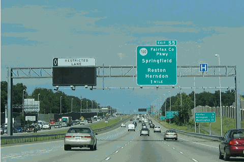
This 2004 photo shows the eastbound I-66 near EXIT 55 (VA 7100 / Fairfax County Parkway) in Centreville. (Photo by Alex Nitzman, www.aaroads.com.) |
||
|
According to VDOT, I-66 carries about 30,000 vehicles per day (AADT) along its rural stretch west to EXIT 40 in Haymarket. However, volumes increases dramatically to 75,000 vehicles per day near Manassas, about 125,000 vehicles per day through central Fairfax County, and about 170,000 vehicles per day along the stretch between EXIT 57 (US 50) and EXIT 65 (I-495). Volumes drops off to about 100,000 vehicles per day "inside the Beltway," though a considerable portion of this traffic carries at least two or more occupants. |
||
|
EXPANSION WEST OF THE BELTWAY: From the 1980s through 2010, I-66 was expanded to eight lanes (from four) from EXIT 57 (US 50) in Fairfax west to EXIT 43 (US 29) in Gainesville, with the left lane in each direction reserved for HOV-2 traffic. The Virginia Department of Transportation (VDOT) considered plans to expand the widening west to EXIT 40 (US 15) in Haymarket, and although the state shelved these plans indefinitely in 2009 due to budget constraints, such plans remain under study. |
||
|
The section between EXIT 57 (US 50) and EXIT 65 (I-495) has maintained its six-lane configuration for through-traffic lanes, but new collector-distribution (C/D) roads and extended exit-only lanes were built to relieve congestion over the years. Nevertheless, with the left lanes in each direction now reserved for HOV-2 traffic, and with additional widening in this area seemingly unlikely, VDOT has permitted the use of shoulders for through traffic in peak-period directions. Although the use of shoulders for through traffic removes a key safety feature of I-66, VDOT countered in a 2008 Washington Post interview (when shoulder use hours were extended) there was no significant increase in accidents when the shoulders were used for rush-hour traffic. There are nine emergency pull-offs along this stretch for disabled vehicles. |
||

|
SPOT IMPROVEMENTS EAST OF THE BELTWAY: The easing of the four-lane restriction stipulated by the "Coleman compromise" in 1999 paved the way for VDOT to reconsider widening I-66 "inside the Beltway." As was the case decades earlier, however, a group of community and environmental activists forced VDOT to drop plans for a full-scale widening to six lanes along the entire stretch. Instead, VDOT plans three spot widenings along the westbound lanes as follows: |
||
|
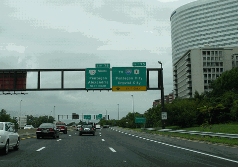
This 2004 photo shows the eastbound I-66 near EXIT 75 (VA 110) in Arlington. The headquarters of USA Today is on the right. (Photo by Laura Siggia Anderson.) |
||

|
SOURCES: "Approach for Airport Urged for Highway 66" by Muriel Gunn, The Washington Post (6/18/1958); "AAA Backs Route in Arlington," The Washington Post (10/15/1958); "Link Picked for Route 66 in Arlington" by Laurence Stern, The Washington Post (6/06/1959); "Arlington Officials Will Ask If Interstate 66 Will Have Room for Transit Facilities," The Washington Post (8/06/1959); "Virginia Approves Next to Last Link of Interstate 66," The Washington Post (8/25/1962); "Highway, Metrorail Suggested in I-66 Corridor" by Douglas B. Feaver and Stephen J. Lynton, The Washington Post (12/12/1975); "Accord Sought on I-66" by Douglas B. Feaver, The Washington Post (12/18/1975); "Arlington Board May Shift on I-66" by Deborah Sue Yaeger, The Washington Post (12/24/1975); Secretary's Decision on Interstate Highway 66, Fairfax and Arlington Counties, Virginia, U.S. Department of Transportation (1977); "US To Halt I-66 Unless Virginia Pays Metro" by Douglas B. Feaver, The Washington Post (1/13/1978); "I-66: Another Court Victory," The Washington Post (3/16/1978); "Virginia Highway Chief Reassures Arlington Officials on I-66" by Sandra G. Boodman, The Washington Post (3/29/1979); "Court Lets I-66 Ruling Stand," The Washington Post (4/15/1980); "I-66 Opening Tentatively Set for December 22" by Jack Eisen, The Washington Post (4/24/1982); "A Long Road" by Stephen J. Lynton, The Washington Post (12/22/1982); "I-66 Inside the Beltway Feasibility Study," Federal Highway Administration and Virginia Department of Transportation (March 2005); "Parts of Interstate 66 Slated for Widening" by Steven Ginsberg, The Washington Post (11/27/2005); "Virginia Extending Shoulder Use on I-66" by Robert Thomson, The Washington Post (8/08/2008); "I-66 Spot Widening To Start" by Robert Thomson, The Washington Post (6/08/2010); Nick Klissas; Scott Kozel. |
||

|
INTERSTATE 66 (VIRGINIA) LINKS: |
||
|
INTERSTATE 66 (VIRGINIA) VIDEO LINKS: |
||
|
INTERSTATE 66 (VIRGINIA) CURRENT CONDITIONS: |
||

|
OFF-SITE EXIT LISTINGS: |
||
|
|
||
|
Back to The Roads of Metro Washington-Baltimore home page. |
||
|
Site contents © by Eastern Roads. This is not an official site run by a government agency. Recommendations provided on this site are strictly those of the author and contributors, not of any government or corporate entity. |
||