
|
|
||
|
This 2016 photo shows the northbound Shirley Highway (I-395) at EXIT 6 (Shirlington Circle) in Arlington. The multi-level interchange was designed to accommodate future construction of the Four-Mile Run Expressway, which was never built. (Photo by Steve Anderson.) |
||
|
Length: |
||
|
9.9 miles (16.0 kilometers); I-95 / I-495 interchange in Springfield to 14th Street Bridge |
||

|
A ROUTE BUILT FOR WAR: Preliminary planning for what is known today as the Shirley Highway began in the 1930s as the Fort Belvoir Bypass. The controlled-access highway, which was to serve as a bypass of US 1 (Jefferson Davis Highway), was to extend 17.3 miles from just north of Woodbridge to the Highway Bridge (now 14th Street Bridge) at the Potomac River. The proposed highway, which was to be a four-lane highway of modern design with median separation and grade-separated interchanges, was to cut 2.4 miles off the existing US 1 and reduce travel times by bypassing the downtowns of Alexandria and Arlington. |
||
|
In 1940, the US Public Roads Administration (PRA) and the Virginia Department of Highways (VDH) decided jointly on a tentative route. The new highway was to receive the VA 350 designation. The northernmost 0.7 mile of the highway was to be co-signed with US 1; the US 1 designation was to continue north into Washington, DC across the 14th Street Bridge. |
||
|
With hostilities building worldwide, and construction of the War Department Building (later called the Pentagon) underway, VDH Commissioner Henry J. Shirley approved construction of the Fort Belvoir Bypass in the spring of 1941. On July 16, 1941, only weeks after approving the highway, Shirley, who had served 19 years as VDH Commissioner, died. Soon thereafter, the Fort Belvoir bypass was renamed after the longest-serving VDH commissioner to date. |
||
|
In the summer of 1941, work began on a four-mile section from the 14th Street Bridge south to VA 7 (Alexandria-Leesburg Highway. This section was part of the Pentagon road system and thus was designed and built directly by the Federal government. The route was built to contemporary freeway standards, with four lanes in each direction, and a grassy median that could accommodate two additional lanes in the future. Interchanges were built at VA 7, Quaker Lane, Glebe Road, Arlington Ridge Road, VA 27 (Washington Boulevard), the Pentagon south parking lot, US 1, Boundary Channel Road, and the George Washington Memorial Parkway. |
||
|
At the same time, the eastern and western branches of VA 27 were built alongside the Shirley Highway in the area of the Pentagon to connect the Shirley Highway to Washington Boulevard and the Pentagon. A complex interchange, known in later years as the "Mixing Bowl," was designed to accommodate the more than 20,000 employees who worked at the Pentagon. |
||
|
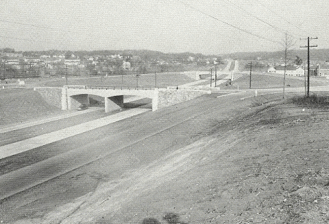
This 1949 photo shows the Shirley Highway interchange at EXIT 6 (Shirlington Circle) in Arlington. Note the parkway-style aesthetic used on the overpasses. (Photo from the Virginia Department of Highways.) |
||
|
EXTENDING SOUTH TO WOODBRIDGE: Work resumed on the Shirley Highway in 1945. Although the original plans called for construction of a six-lane freeway from the 14th Street Bridge south to VA 7, and a four-lane freeway from VA 7 south to US 1. Given the lack of a dedicated highway trust fund in the immediate postwar years, however, there was only enough funding for a four-lane highway south of VA 7 to VA 644 in Springfield, and for a two-lane "super-2" road from VA 644 south to US 1 in Woodbridge. Moreover, a plan to upgrade the highway to six lanes throughout its length was postponed indefinitely. |
||
|
On September 6, 1949, the Shirley Highway was opened to traffic with a four-lane, median-separated configuration from VA 7 in Alexandria to VA 644 in Springfield, and a two-lane undivided "super-2" configuration from VA 644 south to US 1 in Woodbridge. However, the state had purchased right-of-way to build a parallel two-lane roadway from Springfield to Woodbridge. In preparation for the twinning of the Shirley Highway, the Virginia Commonwealth Transportation Board (CTB) added the Shirley Highway to the state's 50,000-pound network in 1951, paving the way for trucks to use the highway despite some opposition from motorists. Upon completion of the parallel roadway on May 24, 1952, northbound traffic used the new parallel roadway, while southbound traffic used the original two-lane roadway. |
||
|
TRAGEDY AT THE TRACKS: Given the limited funds to build the Shirley Highway, one key design compromise was the construction of an at-grade crossing for the Washington and Old Dominion (W&OD) Railroad just north of EXIT 6 (Shirlington Circle). The failure to build a grade separation had dangerous, and in at least one distance, fatal consequences. On June 26, 1952, a dump truck loaded with asphalt failed to brake in time and collided with a W&OD locomotive, killing the driver of the dump truck and injuring several people. The locomotive fell down an embankment, while several freight cars were derailed. |
||

|
By that time, the W&OD Railroad already was in decline, particularly as passenger service ended on the line in 1951, and with the shift in freight traffic from rail to trucks, it appeared the days of the Shirley Highway at-grade crossing were numbered. Although the W&OD was purchased by the Chesapeake & Ohio Railway in 1956, the new owner found little use for the W&OD, and subsequently, parts of the W&OD right-of-way were sold to the VDH for a new I-66 alignment, as well as Virginia Electric and Power Company (now Dominion Virginia Power) for a new power line right-of-way. The Shirley Highway railroad crossing finally was abandoned when the W&OD Railroad ceased operations in 1968. |
||
|
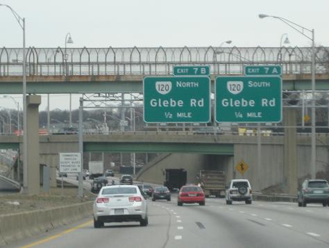
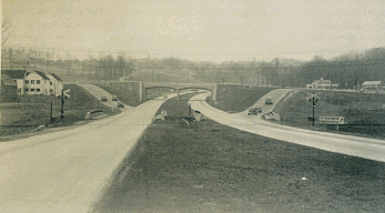
These two photos show a rare at-grade freeway railroad crossing on the Shirley Highway. The top photo from the late 1940s shows the Shirley Highway looking south at EXIT 6 (Shirlington Circle), while the top photo from the mid-1960s shows the Shirley Highway looking north toward EXIT 7 (VA 120 / Glebe Road). |
||
|
BECOMING AN INTERSTATE HIGHWAY, BUT WITH CONDITIONS: In August 1958, Virginia officials formally submitted the southernmost 13.2 miles of the Shirley Highway to be part of the Interstate highway system as I-95. Excluded from this submission was the northernmost 4.1 miles of VA 350, which actually was under the jurisdiction of not the VDH, but the BPR's Pentagon road network. The BPR had intended for the VDH to take over jurisdiction of the Pentagon road network, but the state refused to take on the additional cost to rebuild the Shirley Highway near the Pentagon, and the BPR was unable to secure Congressional funding to rebuild this segment. |
||
|
In 1960, the BPR established the Pentagon Network Study to determine the scope of the work, including planning and preliminary design, which would bring the Shirley Highway to Interstate standards. Jim McDonnell led this team, handling traffic assignments and geometric design trials. He also advanced the idea of a reversible center roadway, which was adopted in the later redesign of the Shirley Highway. |
||
|
What finally brought Virginia officials to the table was the promise of additional Federal financing. In September 1961, a Congressional bill sponsored by Representative Joel Broyhill was enacted such that the Federal government would fund the Shirley Highway north of VA 7 at 95% of the project cost, instead of the usual 90% rate. The bill contained money to widen VA 350 to eight lanes from four, as well as build interchange improvement around the Pentagon. The VDH would assume maintenance responsibility for this stretch upon completion, and at that point, the Shirley Highway would assume the I-95 designation. |
||

|
The cost of upgrading the entire length of the Shirley Highway was estimated at $20 million ($7.5 million for the section north of VA 7 alone), with an additional $1.8 million to upgrade the roadways around the Pentagon. However, it proved a more attractive option than building a parallel Interstate highway--a proposal originally put forward by the VDH--that would have cost tens of millions more. |
||
|
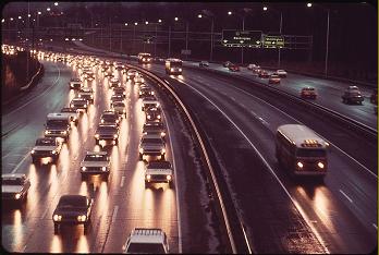
GET ON THE BUS: A single Shirley bus lane was opened to traffic for a 4.5-mile-long stretch on September 22, 1969, and the lane was extended for 1.5 miles in September 1970 and an additional 2.5 miles in April 1971. Within the first few years of operation, the Shirley XBL saved more than 7,000 Virginia bus commuters about 20 minutes of travel time. |
||


|
By 1973, most of the 3-2-3 lane configuration was either completed or in advanced stages of construction, and the single bus lane had become a two-lane reversible roadway. On December 10 of that year, the Shirley express bus lanes were opened to use for automobiles with four or more occupants (HOV-4). According to the Northern Virginia Transportation Commission, there was no drop in bus ridership after the re-designation of the bus lanes as HOV-4 lanes. The lane restriction was loosened to HOV-3, or automobiles with three or more occupants, in October 1988. |
||
|
The last part of the project was a comprehensive redesign of the Pentagon road network. Along a two-and-one-half-mile segment of the Shirley Highway, there were 52 lane-miles of roadways and ramps, several freeway interchanges (EXITS 8-10), and grade-separated roadways that led to the reversible HOV lanes. |
||
|
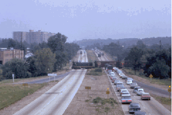
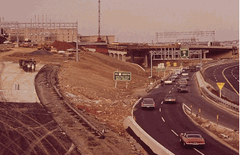
This photos of the Shirley Highway from the early 1970s show the highway -- then designated as I-95 -- approaching Shirlington Circle with the newly completed bus lanes (top photo), and at the Pentagon "Mixing Bowl" interchange, which was under reconstruction (bottom photo). |
||
|
REACHING A CONSENSUS FOR A NEW INTERSTATE DESIGNATION: With the cancellation of I-95 from Washington, DC north to College Park, MD, including parts of the Center Leg, North Leg, and Northeast Freeways, the Virginia CTB recommended that the I-95 designation be shifted onto the Capital Beltway (I-495) north and east of Springfield to the Woodrow Wilson Bridge, and that the remnant section of I-95 north of the Beltway--the Shirley Highway--be re-designated as I-895. |
||
|
The I-895 numbering was approved by the American Association of State Highway and Transportation Officials (AASHTO) on November 11, 1975. However, AASHTO gave final approval to another designation--that of I-395--to the Shirley Highway, as well as to the adjacent sections of the Southwest and Center Leg Freeways, on November 12, 1976. By that time, even a later proposal to route I-95 along the New York Avenue Industrial Freeway (US 50) and the Baltimore-Washington Parkway had been defeated, implying that the orphaned I-95 segment would end as a spur from I-95 in Springfield, VA. New I-395 signs went up along the Shirley Highway during the summer of 1977. |
||


|
REBUILDING THE SPRINGFIELD INTERCHANGE: At the southern end of I-395, the Springfield Interchange between the Shirley Highway, the Capital Beltway (I-95 / I-495), and the mainline I-95 south toward Richmond strained to accommodate 430,000 vehicles per day by the mid-1990s, nearly triple of volume it had in the early 1970s. Much of the bottleneck came from the I-95 through interchange movements, which had become more complicated with the cancellation of I-95 through Washington, DC and the subsequent relocation of the I-95 designation onto the Capital Beltway. A study by the National Highway Traffic Safety Administration (NHTSA) found that the interchange was the site of 179 accidents in 1993 and 1994; this represented twice the accident rate of any other Beltway interchange. |
||
|
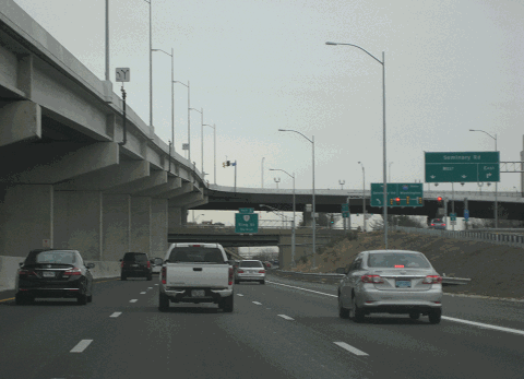
This 2016 photo shows the northbound Shirley Highway (I-395) at EXIT 4 (Seminary Road / unsigned VA 420) in Alexandria. Note the newly constructed bridges connecting the express lanes of Seminary Road with the HOV (future HO/T) lanes, which were built in the mid-2010s. (Photo by Steve Anderson.) |
||
|
FROM HOV TO HO/T: On December 14, 2014, VDOT and private partner Transurban completed a $925 million project to convert the existing HOV lanes on I-95 in Northern Virginia to high-occupancy toll, or HO/T lanes. The project, which included the conversion of about 2.7 miles of I-395 from the Capital Beltway north to the mainline / HOV lane crossover on the Springfield-Alexandria border, including the construction of rebuilt entrance and exit ramps, as well as sound walls. |
||
|
Construction began in November 2017 on a $480 million project to extend the I-395 HO/T lanes over the existing HOV roadway north to the 14th Street Bridge. The existing two-lane HOV roadway is being converted to three reversible HO/T lanes. However, the lanes would be restricted to HOV-3 use during weekday morning and afternoon peak periods. Outside of rush hour, the all-electronic toll lanes, which accept EZ-Pass, would be free for automobiles with three or more occupants, buses, and motorcycles; other vehicles would have to pay a toll. The HO/T lane project is scheduled for completion in late 2019. |
||
|
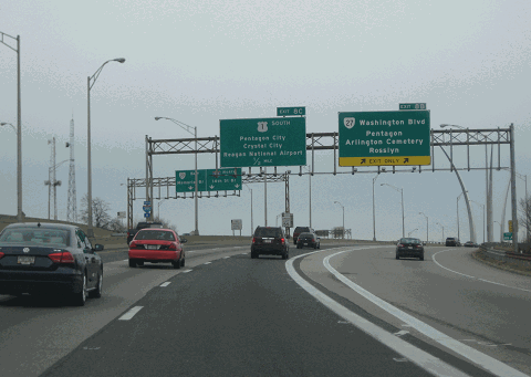
This 2016 photo shows the northbound Shirley Highway (I-395) at EXIT 8B (VA 27 / Washington Boulevard) in the Pentagon City neighborhood of Arlington. On the right side of the photo is the US Air Force Memorial, which was dedicated in 2006. (Photo by Steve Anderson.) |
||

|
SOURCES: "Virginia Has Four Million Road Project," The Washington Post (9/16/1943); "New Shirley Highway Open to Traffic," The Washington Post (4/26/1944); "Shirley Highway Work Conference Set for July 4," The Washington Post (6/28/1944); "Shirley Road Saves Time, Test Reveals" by John London, The Washington Post (9/07/1949); "Driver Dies as Truck Derails Locomotive Crossing Shirley," The Washington Evening Star (6/27/1952); "County Board Calls for Widening of Shirley Highway Now" by Susanna McBee, The Washington Post (7/02/1961); "House Votes 8-Lane Shirley Highway" by James R. Carberry, The Washington Post (9/07/1961); "Two Ways for Widening of Shirley Highway Offered," The Washington Post (7/05/1962); "Just Follow the Signs" by Jack Eisen, The Washington Post (5/03/1964); "First Contract Let for the Widening of Shirley Highway to Eight Lanes," The Washington Post (4/15/1965); "Express Buses on Route 95 Dash 4 Miles--To Bottleneck" by Kenneth Bredemeier, The Washington Post (9/23/1969); Reserved Lanes for Buses: The Shirley Highway Experiment, Institute for Defense Analyses (1970); "Virginia Commuters Hail Reserved Bus Lane Idea" by Robert Lindsey, The New York Times (2/12/1971); "33-Year Road Project Nears Completion" by Athelia Knight, The Washington Post (6/21/1975); "A Summer Album," The Washington Post (9/08/1977); "In Virginia, 8 Miles Between Success and Failure" by Andrew C. Revkin, The New York Times (1/21/1996); "Virginia Gets $1 Billion Toll Lane Proposal" by Lisa Rein, The Washington Post (3/17/2004); "Celebrating Mixing Bowl's Big Makeover: Dedication Is Set for Today at Revamped Interchange" by Eric M. Weiss, The Washington Post (7/18/2007); "Next on Virginia's Extension Toll Road System: Interstate 395" by Luz Lazo, The Washington Post (11/25/2017); Federal Highway Administration; Virginia Department of Transportation; Adam Froehlig; Scott Kozel; Alex Nitzman; Mike Roberson; Craig Swain; William F. Yurasko. |
||
|
SHIRLEY HIGHWAY LINKS: |
||
|
SHIRLEY HIGHWAY CURRENT TRAFFIC CONDITIONS: |
||
|
SHIRLEY HIGHWAY VIDEOS: |
||

|
THE EXITS OF METRO WASHINGTON-BALTIMORE: |
||
|
|
||
|
Back to The Roads of Metro Washington-Baltimore home page. |
||
|
Site contents © by Eastern Roads. This is not an official site run by a government agency. Recommendations provided on this site are strictly those of the author and contributors, not of any government or corporate entity. |
||