
|
|
||
|
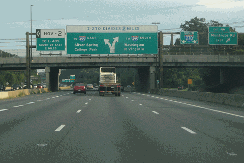
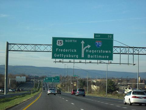
This 2012 photo shows the southbound I-270 at EXIT 4 (Montrose Road) in Rockville. The split for the Capital Beltway's eastbound lanes (I-495 eastbound via I-270 mainline) and southbound lanes (I-495 southbound via Spur I-270) lies two miles ahead. The southern third of I-270 was rebuilt with collector-distributor (C/D) lanes from 1986 to 1991. (Photo by Steve Anderson.) |
||
|
Length: |
||
|
32.6 miles (52.5 kilometers); mainline and east wye |
||
|
Constructed: |
||
|
1950-1960 |
||
|
CONNECTING THE BELTWAY TO I-70: In 1944, the National Capital Park and Planning Commission (NCPPC) announced plans for a new freeway connecting Washington, DC with the central Maryland city of Frederick. The freeway, which was designation as a relocation of then-US 240 (now MD 355), was designed as part of an early plan for a nationwide network of Interstate highways. The proposed US 240 Freeway was to be a spur from the mainline US 40, which was to continue east to Baltimore and points east. |
||
|
As originally planned, the US 240 Freeway was to bypass Bethesda, Rockville, and Gaithersburg. South of Bethesda, one plan had the US 240 Freeway traversing through Bethesda, entering the District of Columbia at Friendship Heights, and continuing southwest through Tinleytown to connect to MacArthur Boulevard near the Chain Bridge. An alternative proposal had the US 240 Freeway veering southwest toward the current route of the Cabin John Parkway, then continuing along the Potomac River shoreline toward the Chain Bridge. In 1946, the NCPPC approved the Cabin John-Potomac River routing, which was to have been known on the Washington, DC side of the border as the Northwest Freeway. |
||

|
The NCPPC released additional plans on the "western alternative" route in 1949, and provided plans to connect to a new highway into northern Virginia that eventually was incorporated into the Capital Beltway (I-495). Although neither the western nor the eastern alternative was built into the District of Columbia, the two alternative proposals survive today as the east and west wyes of I-270 connecting to the Capital Beltway in Bethesda. |
||
|
Work began in 1950 on construction of the new Washington National Pike, as it soon became known, and by 1951, a 10-mile-long section was built from Frederick south to EXIT 22 (MD 109 / Old Hundred Road) in Clarksburg, Montgomery County. By 1953, the freeway was extended south by another four miles to EXIT 18 (MD 121/ Clarksburg Road) in Clarksburg. The US 240 Freeway was extended south three miles to EXIT 15 (MD 118 / Germantown Road) in Germantown in 1955, and by another nine miles to EXIT 6 (MD 28 / West Montgomery Avenue) in Rockville in 1956. |
||


|
US 240 BECOMES AN INTERSTATE: By this time, the Maryland State Highway Administration (SHA) had devised plans for the Capital Beltway (I-495), which was to collect the traffic generated by the US 240 Freeway, which now was designated I-70S. To support the large volume of traffic generated by I-70S, planners split the freeway into two wyes. The first wye, which was to continue the I-70S designation to the east, was to connect to the Capital Beltway near Wisconsin Avenue (MD 355), and eventually to a proposed--but left unbuilt--project called the North Central Freeway. The second wye, which was to be designated I-270, was to be built due south from the wye split and connect to the Capital Beltway near the Bethesda Country Club. |
||
|
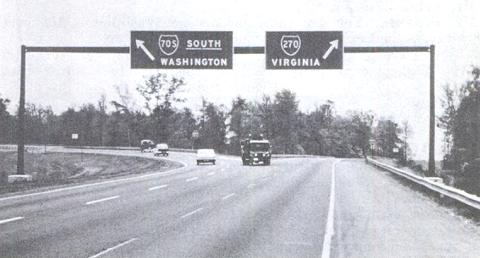
This mid-1960s photo shows the split of the eastern and western wyes of what was then known as I-70S. Then as now, the eastern wye continued the designation of the mainline I-70S route, while the western wye had a separate designation of I-270. (Photo from "Highway Safety, Design, and Operations: Freeway Signing and Related Geometrics," US Government Printing Office (1968). |
||
|
A FREEWAY TO THE NORTHWEST: The Washington National Pike was completed in its entirety in 1960 when the mainline freeway south of EXIT 6, along with the eastern and western wyes, was completed south to the Capital Beltway. The parallel route, which historically had been US 240, now was designated MD 355, while the US 240 designation disappeared with the completion of I-70S and the I-270 western wye. |
||
|
The completion of I-70S not only spurred suburban development along the route, but also the expansion and de-centralization of the Federal government in post-World War II America. The headquarters of several Federal agencies, including the National Institutes of Health (1953), Atomic Energy Commission (1957, later became headquarters for the US Department of Energy) and the National Bureau of Standards (1966) all established headquarters along I-70S. Private sector firms such as IBM, Lockheed Martin, Comsat Corporation, and C&P Telephone (now Verizon) with Federal government contracts, as well as other firms such as Marriott, later developed their own office complexes along the freeway. As the new millennium approached, biotechnology firms established their own headquarters along the freeway, which a 2000 Time magazine article called "DNA Alley." |
||
|
A NEW NAME: On May 18, 1975, the American Association of State Highway and Transportation Officials (AASHTO) approved the change of the I-70S designation to I-270, which applied to the mainline freeway and the eastern wye, although the Maryland SHA began promoting this change on highway signs months earlier. The western wye, which already had the I-270 designation, was redesignated as "I-270 Spur," or "I-270Y," though signs in the area simply refer to the western wye as I-270. At the same time, the I-70N designation from Frederick toward Baltimore became simply I-70. |
||

|
However, there was a 1975 Virginia Department of Transportation (VDOT) map showing the western wye as I-470, showing that officials considered a new designation altogether for the spur route. The I-470 designation may have been submitted to AASHTO by the Maryland SHA, but the proposed designation change may have been denied. |
||
|
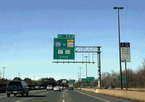
This 2012 photo shows the northbound I-270 at the ramp to the C/D road for EXIT 9 (I-370 to MD 200 / Intercounty Connector and Sam Eig Highway) and EXIT 10 (MD 117 / MD 124) in Gaithersburg. (Photo by John Winder.) |
||
|
CONGESTION RELIEF: In 1972, the Maryland SHA widened a 13-mile-long stretch of I-270 to six lanes from the wye split in Bethesda to EXIT 15 (MD 118) in Germantown. However, at that point officials acknowledged this widening would not be enough to relieve congestion, and that more drastic measures would need to be taken, particularly as development continued along the route. The Maryland SHA even devised an ambitious plan to build a new parallel freeway about one to two miles west of I-270. The state-backed plan was blocked by Montgomery County officials. However, a four-to-six-lane arterial boulevard, the 7.4-mile-long Great Seneca Highway (MD 119), was built in its place in the 1980s to relieve congestion through Gaithersburg and Germantown. |
||
|
BUILDING A 12-LANE COLUSSUS: In 1984, the Maryland SHA recommended the construction of a 12-lane roadway to separate local and express traffic. By that time, traffic had grown to 125,000 vehicles per day (AADT), and I-270 was expected to carry 220,000 vehicles per day by 2010. Unlike the contention which had held up construction of the Outer Beltway, and later the Intercounty Connector (MD 200) for decades, there was consensus among state and Montgomery County officials that I-270 needed to be widened. |
||
|
HOV LANES AND SPUR WIDENING: Left mostly untouched by the late 1980s widening project, however, were the west and east eyes. There also was no HOV provision in the widening project, and given the next wave of development that followed the I-270 widening, With traffic counts growing to 185,000 vehicles per day by the mid-1990s, state and county officials advanced the construction of new HOV lanes. |
||

|
The east and west wyes were widened to three lanes in each direction, with the new lanes reserved for HOV use during peak periods. The new HOV lanes were extended directly into the left-most express lanes on the mainline I-270, which were built for the widening project a decade earlier and converted into HOV lanes, and the new mainline HOV lanes extended for the entire length of the 12-lane section from the wye split to northwest to MD 121. A new flyover ramp also was built to connect the northbound east wye HOV lane directly into the new northbound mainline HOV lane, while the southbound east wye overpass over the northbound west wye lanes was rebuilt to accommodate the new lanes. The HOV project was completed on December 19, 1996. |
||
|
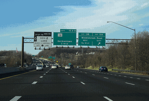
In this 2012 photo, this northbound view of I-270 shows the 12-lane, quad-carriageway transitioning to an eight-lane, dual-carriageway design north of Gaithersburg. HOV lanes were added to I-270 in 1996. (Photo by John Winder.) |
||
|
THE NEW EXIT 12: Work began in early 2018 on a new EXIT 12 to serve Watkins Mill Road at the Gaithersburg-Germantown border. The $98 million project, which is slated for completion in the summer of 2020, is comprised of building a new overpass for Watkins Mill Road, which now dead-ends on both sides of I-270, new "diamond" slip ramps connecting directly to I-270, and a relocated exit ramp for southbound EXIT 11 (MD 124). |
||
|
AMBITIOUS PLAN TO ADD HO/T LANES: On September 20, 2017, Governor Larry Hogan announced a $5 billion statewide plan to add express toll lanes to I-270, I-495, and the Baltimore-Washington Parkway (MD 295), the latter of which in its entirety would be transferred from the federal government to the Maryland Transportation Authority (MdTA). |
||
|
This 2011 photo shows the northbound I-270 approaching its terminus at I-70 in Frederick. Toward the northern end of I-270, the freeway narrows to two lanes in each direction. The alignment of I-270 continues north along the Frederick Freeway (US 15). (Photo by Doug Kerr.) |
||

|
SOURCES: "Low Bid Listed for Improvement on National Pike," The Washington Post (9/20/1950); "New Gateway to Northwest Mapped Here" by Chalmers M. Roberts, The Washington Post (12/24/1950); "Second Leg of Pike To Open in Mid-May," The Washington Post (4/26/1953); "Markers Adopted for New US Route Numbers" by G. K. Hodenfield, The Washington Post (9/27/1957); "City May Ask Route 70-S East of Park," The Washington Post (3/13/1960); "Route I-70S in Maryland Quietly Becomes Known as I-270" by Jack Eisen, The Washington Post (3/02/1975); "Highway Panel Sets 12 Lanes for I-270" by R.H. Melton, The Washington Post (1/25/1984); "Montgomery Road Plans Accelerate" by R. H. Melton, The Washington Post (2/22/1985); "I-270 Construction," The Washington Post (7/11/1985); "Widening of I-270 Is Blocked" by Neil Henderson, The Washington Post (2/14/1987); "Update on I-270," The Washington Post (3/10/1989); "12-Lane I-270 Makes Debut in Montgomery," The Washington Post (10/14/1990); "Unclogging I-270's Spurs" by Ron Shaffer, The Washington Post (3/14/1991); "Maryland Plans HOV Lanes on I-270" by Stephen Fehr, The Washington Post (10/31/1992); "The Scoop on I-270 Spurs" by Ron Shaffer, The Washington Post (2/09/1995); "A Respite on I-270" by Ron Shaffer, The Washington Post (12/12/1996); Montgomery Modern: Modern Architecture in Montgomery County, Maryland, 1930-1979 by Clare Lise Kelly, Maryland-National Capital Park and Planning Commission (2015); "Maryland Governor Larry Hogan Proposes Widening the Beltway and I-270 To Include Four Toll Lanes" by Robert McCartney, Faiz Siddiqui, and Ovetta Wiggins, The Washington Post (9/21/2017); "Work Begins on New I-270 Interchange" by Dave Dildine, WTOP Radio (4/23/2018); Maryland Department of Commerce; Maryland State Highway Administration; Scott Kozel; Alex Nitzman; William F. Yurasko. |
||
|
WASHINGTON NATIONAL PIKE LINKS: |
||
|
I-270 (MARYLAND) CURRENT TRAFFIC CONDITIONS: |
||
|
I-270 (MARYLAND) VIDEOS: |
||

|
THE EXITS OF METRO WASHINGTON-BALTIMORE: |
||

|
Back to The Roads of Metro Washington-Baltimore home page. |
||
|
Site contents © by Eastern Roads. This is not an official site run by a government agency. Recommendations provided on this site are strictly those of the author and contributors, not of any government or corporate entity. |
||